Florida Freeze Watches Issued as Cold Air Surges Overnight, Raising Questions About Whether This Could Be the Final Freeze of the Season
FLORIDA — A late-season surge of cold air is pushing into the state overnight, bringing freeze watches and warnings across North Florida and setting the stage for one of the coldest mornings Florida has seen in weeks. Forecast guidance also suggests this event could play a role in a broader seasonal transition toward warmer weather later this month.
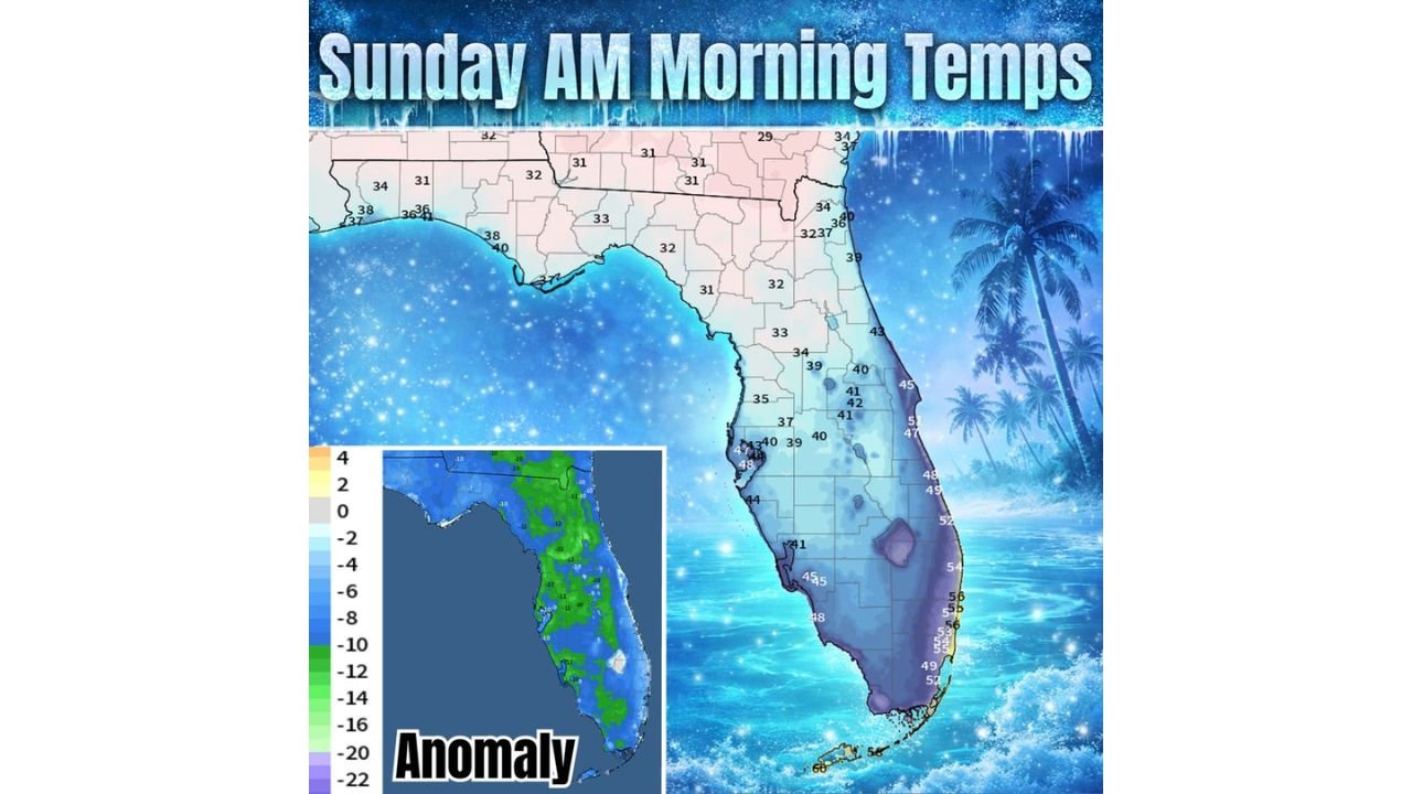
Sunday Morning Brings Near-Freezing Temperatures Across North Florida
Temperature guidance shows a clear north-to-south divide early Sunday morning. Much of North Florida and the Panhandle are expected to fall to around 30–32°F, with some inland areas briefly dipping below freezing. These readings are cold enough to support frost and freeze conditions, particularly away from the immediate coastline.
Central Florida is forecast to bottom out mainly in the mid-30s to low-40s, while South Florida remains milder, with lows generally holding in the upper-40s to mid-50s.
Cold Anomaly Confirms an Unseasonably Chilly Air Mass
The temperature anomaly data shows much of Florida running well below seasonal averages, especially across the northern and central portions of the peninsula. In several areas, temperatures are projected to be 5 to 15 degrees colder than normal, highlighting the strength of this cold intrusion despite the calendar pushing deeper into February.
Freeze Watches and Warnings Focus on Northern and Interior Areas
Because of the expected overnight lows, freeze watches and warnings are in effect for parts of North Florida, where sensitive vegetation and early agricultural growth could be impacted. Interior and rural locations are most vulnerable, particularly where winds calm overnight and allow temperatures to drop efficiently before sunrise.
Coastal areas are expected to remain slightly warmer due to the moderating influence of nearby waters.
Signs of a Seasonal Pattern Shift After This Cold Shot
While this cold event is significant, longer-range trends suggest warmer conditions may dominate in the weeks ahead. Meteorologists often refer to this transition as a seasonal “pattern flip,” when cold air masses become weaker and less frequent as spring approaches.
A weaker front around Valentine’s Day weekend may bring a brief cooldown, but current signals indicate nothing as intense as the freezes Florida has already experienced this winter.
Why This Freeze Could Matter for the Rest of the Season
If warmer trends hold, this event may represent one of the final meaningful freeze risks of the season for Florida. While February can still produce surprises, the overall pattern is beginning to favor reduced freeze potential moving forward.
Residents in freeze-prone areas should still take precautions tonight, especially to protect plants and exposed pipes.