Florida Sees Drought Relief Potential as Heavy Rain Targets Orlando, Daytona and East Coast With Flood Risk
FLORIDA — A multi-day rain event is expected to impact the entire Florida Peninsula through the workweek, bringing much-needed drought relief but also raising concerns for localized flooding and strong winds, especially along the central and eastern parts of the state.
Forecast data shows rainfall totals increasing steadily from Monday through Friday, with some areas potentially seeing significant accumulations.
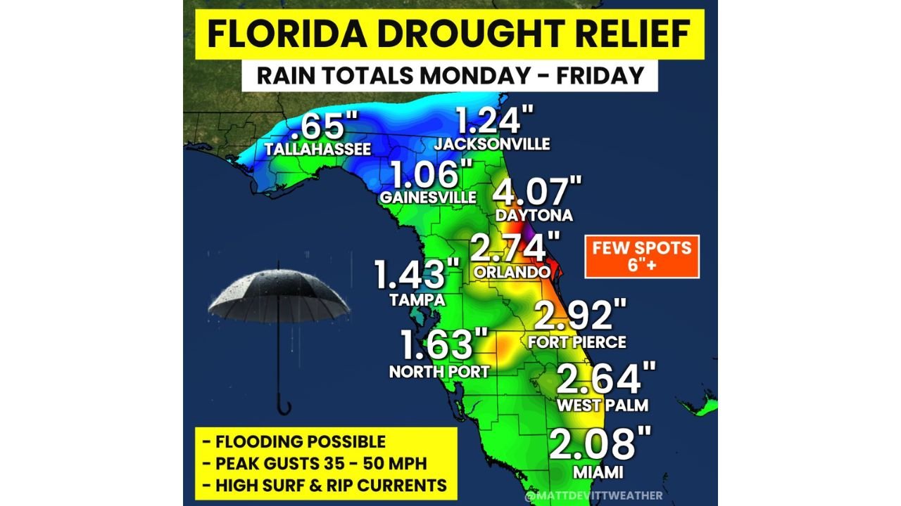
Rainfall Totals Vary Across Florida but Increase Toward the East
Projected rainfall amounts highlight a clear gradient across the state:
- Daytona Beach: around 4.07 inches, among the highest totals
- Orlando: near 2.74 inches
- Fort Pierce: approximately 2.92 inches
- West Palm Beach: around 2.64 inches
- Miami: near 2.08 inches
Across the Gulf side:
- Tampa: about 1.43 inches
- North Port: around 1.63 inches
- Gainesville: near 1.06 inches
- Jacksonville: about 1.24 inches
The Florida Panhandle, including Tallahassee, may see lighter totals overall, though localized variations are possible.
Central Florida East Coast Faces Heaviest Rain Threat
The most intense rainfall is expected along the central Florida east coast corridor, including:
- Orlando
- Daytona Beach
- Surrounding inland and coastal communities
This region is most likely to experience:
- Prolonged periods of rain
- Heavier downpours embedded within storm bands
- Increased chances for localized flooding
Some isolated areas could even exceed 6 inches of total rainfall, especially where storms repeatedly move over the same locations.
Flooding and Wind Risks Accompany the Rainfall
Alongside the rainfall, additional hazards are expected:
- Localized flooding, particularly in low-lying or urban areas
- Wind gusts between 35 to 50 mph, especially near stronger storm bands
- Coastal impacts including:
- High surf conditions
- Increased risk of rip currents along Atlantic beaches
These conditions will be most noticeable along the east coast, where both rainfall and wind are expected to be strongest.
Rain Brings Relief but Won’t Fully End Drought
While the incoming rain will help:
- It is not expected to completely eliminate drought conditions
- However, it will provide meaningful short-term relief, especially in areas that have been significantly dry
The benefit depends heavily on:
- How evenly the rainfall is distributed
- Whether heavier totals fall over the most drought-affected regions
Timing Through the Week
- Monday–Tuesday: Rain begins and spreads across the peninsula
- Wednesday–Thursday: Peak coverage with widespread showers and storms
- Friday: Gradual tapering, though lingering showers remain possible
The extended duration of this event increases the likelihood of accumulating rainfall totals across multiple days.
What Residents Should Expect
Florida residents should prepare for:
- Several consecutive days of unsettled weather
- Periods of heavy rain and thunderstorms
- Changing conditions depending on location, especially between west and east coasts
Those in flood-prone areas or along the coast should remain especially alert during peak rainfall periods.
Stay With Cabarrus Weekly for Florida Weather Updates
Cabarrus Weekly will continue monitoring this multi-day rain and storm pattern across Florida, including updates on:
- Rainfall totals and flooding potential
- Wind and coastal impacts
- Changes in storm timing and intensity
Stay connected for the latest weather coverage as Florida navigates this impactful stretch of rain and storms.