Florida Severe Storm Threat Builds After Daytona 500, With Damaging Winds and Brief Tornado Risk From Pensacola to Jacksonville
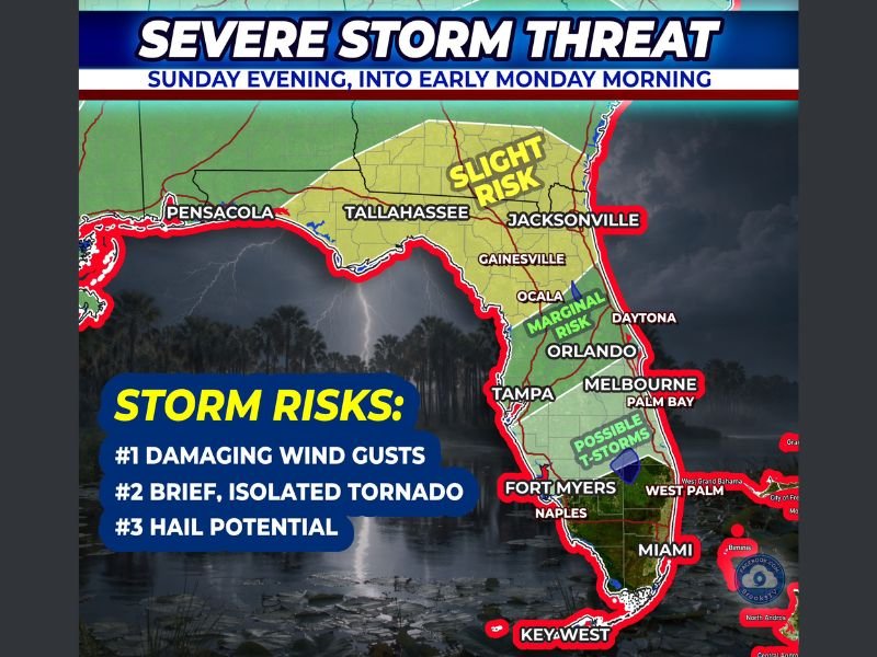
FLORIDA — Severe weather is expected to develop across parts of the state Sunday evening into early Monday morning, with the greatest concern arriving after the Daytona 500 concludes and thousands begin traveling home.
The race itself is expected to remain dry, but forecasters warn that the atmosphere will rapidly become more unstable after sunset. Storms are forecast to build between 8 PM and 10 PM, especially as traffic increases along major corridors including I-95 and I-4.
Slight Risk Across North Florida From Pensacola to Jacksonville
Forecast data shows a Slight Risk of severe storms stretching across Pensacola, Tallahassee, and Jacksonville, covering much of North Florida. This zone carries the highest potential for organized strong storms late Sunday evening.
Within this area, the primary concern is damaging wind gusts, particularly from elevated storms that may not produce widespread heavy rainfall but can still generate powerful bursts of wind. These types of storms are capable of pushing strong gusts down to the surface even without classic Florida-style downpours.
Communities from the western Panhandle through the Big Bend and into northeast Florida should be prepared for sudden wind impacts that could affect travel and outdoor activity after dark.
Marginal Risk Extends South Toward Orlando and Tampa
Farther south, a Marginal Risk extends into parts of Central Florida, including Gainesville, Ocala, Orlando, Tampa, and Melbourne. While the severe threat is lower here, storms could still produce strong winds and locally heavy rain as the line pushes through overnight.
Forecasters also indicate the possibility of additional thunderstorm development across interior and southern sections, including areas near Fort Myers and Naples, where “possible thunderstorms” are highlighted.
The overall risk decreases toward South Florida, including Miami and Key West, but lightning and periods of rain cannot be ruled out.
Main Threat: Damaging Wind Gusts
The number one concern with this setup is damaging wind gusts. Elevated storms can produce strong winds that reach the ground quickly, sometimes with little warning. These gusts may be strong enough to cause isolated power outages, tree damage, or hazardous driving conditions.
Because many people will be traveling after the Daytona 500, timing is critical. The window between 8 PM and 10 PM appears most active for North Florida, aligning with peak travel flow on major highways.
Drivers along I-95 and I-4 should be prepared for sudden downpours, reduced visibility, and gusty winds that could make high-profile vehicles more difficult to control.
Brief, Isolated Tornado Risk
Forecasters are also monitoring a brief tornado risk across North Florida, particularly if a few surface-based cells develop ahead of the main line of storms.
While a tornado is not guaranteed, the risk is not zero. Any discrete storm that forms ahead of the primary squall line could briefly rotate, especially in the Slight Risk zone from Tallahassee to Jacksonville. Residents should have a reliable way to receive weather warnings Sunday night, especially after sunset when visibility decreases.
Hail Potential Remains Isolated
A third threat in this setup is isolated hail. While not expected to be widespread, stronger storm cores could briefly produce small hailstones. This risk appears secondary compared to damaging wind potential. Still, hail cannot be ruled out in the stronger cells embedded within the line.
Timing Is Everything After the Race
The key takeaway from this forecast is that the Daytona 500 itself is expected to stay dry, but the weather pattern shifts after sunset. As the atmosphere “flips a switch,” instability increases and storms organize across North Florida.
The concern is less about the event itself and more about the drive home, particularly for those heading north or west from Daytona through Jacksonville, Tallahassee, and toward the Panhandle. Storms are expected to gradually shift east and south overnight into early Monday morning.
If you or someone you know is traveling across Florida Sunday night, make sure they are aware of the timing and potential for strong storms. Share your local conditions and travel updates with us at CabarrusWeekly.com so others can stay informed.