Florida, Southern Plains, Mississippi Valley and the West Face Active 7-Day Weather Pattern With Heavy Rain, Mountain Snow, Severe Storms and Flooding Risk From April 7 Through April 14
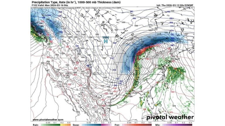
UNITED STATES — A significant and wide-ranging weather pattern is unfolding across the United States over the next seven days. While the Mid-Atlantic and Southeast coast remain mostly dry, three separate and distinct weather stories are developing simultaneously — bringing heavy rain and thunderstorms to Florida’s east coast, much-needed rain and mountain snow to the West, and a potentially dangerous return of severe weather and heavy rainfall across the Southern Plains and Middle Mississippi Valley by the weekend and into early next week.
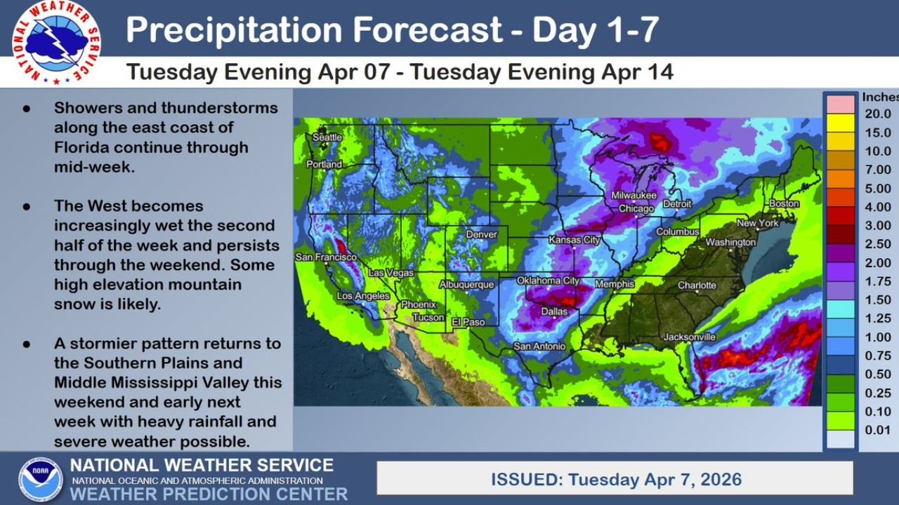
This forecast was issued by the National Weather Service Weather Prediction Center on Tuesday, April 7, 2026, valid through Tuesday, April 14, 2026.
Florida’s East Coast Stays Unsettled Through Mid-Week
Residents along Florida’s Atlantic shoreline are not getting a break this week. Showers and thunderstorms are continuing through mid-week across the east coast of Florida — from Jacksonville southward through Daytona Beach, the Space Coast, and into the Palm Beach and Miami corridors.
This persistent unsettled pattern is being driven by a lingering onshore flow keeping moisture and instability focused along Florida’s eastern coastline. No major severe weather is expected with this activity, but locally heavy rainfall, frequent lightning, and rough surf conditions will continue to affect beach communities and coastal residents through Wednesday and Thursday.
Those with outdoor plans along Florida’s east coast mid-week should plan around afternoon and evening storm activity and avoid the water during active lightning.
The West Gets Much-Needed Rain and Mountain Snow Late Week
After weeks of record-breaking heat and critically dry conditions across the western United States, relief is finally arriving. The West becomes increasingly wet during the second half of the week — with a series of Pacific systems pushing onshore and delivering rainfall to coastal and inland communities from Seattle and Portland through San Francisco, Los Angeles, and into the desert Southwest.
The precipitation arrives and persists through the weekend — giving drought-stressed soils across California, Nevada, Arizona, and the broader Southwest a sustained opportunity to recover. This is not a one-day event. The wet pattern builds through Thursday and continues through Saturday and Sunday across much of the region.
At higher elevations, mountain snow is likely — a welcome development for western snowpack that took a significant hit during March’s record warmth. The Sierra Nevada, Cascades, and Rocky Mountain ranges can all expect meaningful snow accumulations at elevation during the late-week and weekend period.
Residents in the West should prepare for:
- Wet roads and reduced visibility during active rain periods
- Mountain passes potentially impacted by snow — check road conditions before traveling to higher elevations late week and through the weekend
- Runoff from rain on already-dry soils — the first significant rain after a prolonged dry period can cause localized flooding in burn scars and steep terrain
Southern Plains and Mississippi Valley — Severe Weather and Heavy Rain Return This Weekend
The most significant weather story of the seven-day period involves the return of a stormier and potentially dangerous pattern across the Southern Plains and Middle Mississippi Valley starting this weekend and continuing into early next week.
The same general corridor that has been battered by repeated rounds of severe weather over the past two weeks is once again in the crosshairs. A fresh atmospheric setup is delivering heavy rainfall and severe weather potential back into Oklahoma City, Dallas, Kansas City, and the Memphis corridor by the weekend — with the heaviest precipitation signal on the 7-day forecast map concentrated across the central Gulf Coast, southern Mississippi, Alabama, and western Florida where 7 to 15-plus inches of total rainfall are indicated through April 14.
This is on top of the significant rainfall that has already fallen across this corridor over the past several weeks. Soils are saturated, rivers are running high, and drainage systems across the Southern Plains and Mississippi Valley have limited remaining capacity to absorb additional rainfall without producing flooding.
The areas facing the highest concern include:
- Oklahoma City and central Oklahoma
- Dallas and north Texas
- Kansas City corridor
- Little Rock and central Arkansas
- Memphis and west Tennessee
- Southern Mississippi and Alabama
- Gulf Coast communities already dealing with elevated water levels
Why the Weekend Severe Weather Return Matters
When a stormier pattern returns to an already saturated region, the severe weather threat extends beyond the immediate storm hazards of tornadoes, hail, and damaging winds. It creates a compounding multi-hazard environment where:
- Flash flooding can occur even with modest rainfall rates because the ground cannot absorb additional water
- River flooding along the Mississippi, Arkansas, and Tennessee river systems will continue rising with each new rainfall event
- Severe thunderstorm potential remains real across the same corridor that has already seen multiple tornado outbreaks this spring
Residents across the Southern Plains and Mississippi Valley should not treat this weekend’s returning storm pattern as just another storm day. It is arriving into a landscape that has been under sustained weather stress for weeks — and the cumulative impact of one more significant rainfall and severe weather event across this corridor is meaningfully more dangerous than it would be under normal conditions.
Forecast Confidence Level
High confidence on Florida east coast shower and storm activity continuing through mid-week — the onshore flow pattern is well-established.
High confidence on the West becoming increasingly wet late week through the weekend** — multiple Pacific systems are lined up and consistent across forecast models.
High confidence on mountain snow at higher western elevations late week** — temperatures and moisture support snow above approximately 5,000 to 6,000 feet across the Sierra, Cascades, and Rockies.
Medium confidence on exact severe weather coverage and rainfall totals across the Southern Plains and Mississippi Valley this weekend** — the stormier pattern is locked in but specific storm tracks, tornado potential, and rainfall distribution will become clearer by Thursday and Friday.
Preparation Across All Impacted Regions
Florida east coast residents — plan around afternoon and evening storms through mid-week. Keep lightning safety in mind for any outdoor or beach activities.
Western residents — welcome the rain but prepare for it. Check road conditions for mountain travel, be aware of runoff flooding potential in steep terrain and burn scar areas, and allow extra travel time during active rain periods.
Southern Plains and Mississippi Valley residents — this is the most critical preparation message of the seven-day period. If you live in a flood-prone area, along a river corridor, or in a community that has already seen flooding this spring, do not wait for this weekend’s storms to arrive before taking precautions. Move valuables out of flood-prone spaces now, know your evacuation route, and monitor river level forecasts daily through the weekend.
Cabarrus Weekly Perspective
The NWS 7-day forecast map tells a clear story — while parts of the country are getting a break, the Southern Plains and Mississippi Valley are heading into another round of potentially significant weather on top of an already stressed landscape.
The 7 to 15-plus inch precipitation signal across southern Mississippi, Alabama, and the Gulf Coast is one of the more striking features of this forecast — and it is arriving into a region where the ground simply has nowhere left to put additional water without producing flooding. That combination of atmospheric threat and saturated ground is what separates this weekend’s setup from a routine severe weather event.
Monitor forecasts daily through the week. The details will sharpen significantly by Thursday and Friday — and early awareness gives residents across every impacted region the best possible chance to stay safe.
Stay ahead of dangerous weather before it reaches your door. Visit cabarrusweekly.com for daily severe weather coverage, flood alerts, and forecast updates from across the United States — because knowing early is the difference that matters.