Florida Storm Pattern Builds With Gulf Moisture Surge Bringing Heavy Rain and Thunderstorms Through Tuesday
FLORIDA — A developing weather pattern across the Florida Peninsula is setting the stage for multiple rounds of rain and thunderstorms, beginning Monday and peaking into Tuesday as Gulf moisture pushes inland from west to east.
Forecast data indicates two distinct storm phases, with increasing coverage and intensity before conditions finally improve later in the week.
Round One Brings Inland Storms Across the Peninsula
The first phase is already underway:
- Numerous inland thunderstorms developing across Florida on Monday
- Activity focused more toward the eastern side of the peninsula, including areas near Orlando, Daytona Beach, and down toward South Florida
- Some coastal showers, but the bulk of stronger activity remains inland
These storms are expected to produce:
- Brief heavy downpours
- Localized lightning
- Spotty but intense rain pockets
As the day progresses, this activity will gradually push eastward toward the Atlantic coast.
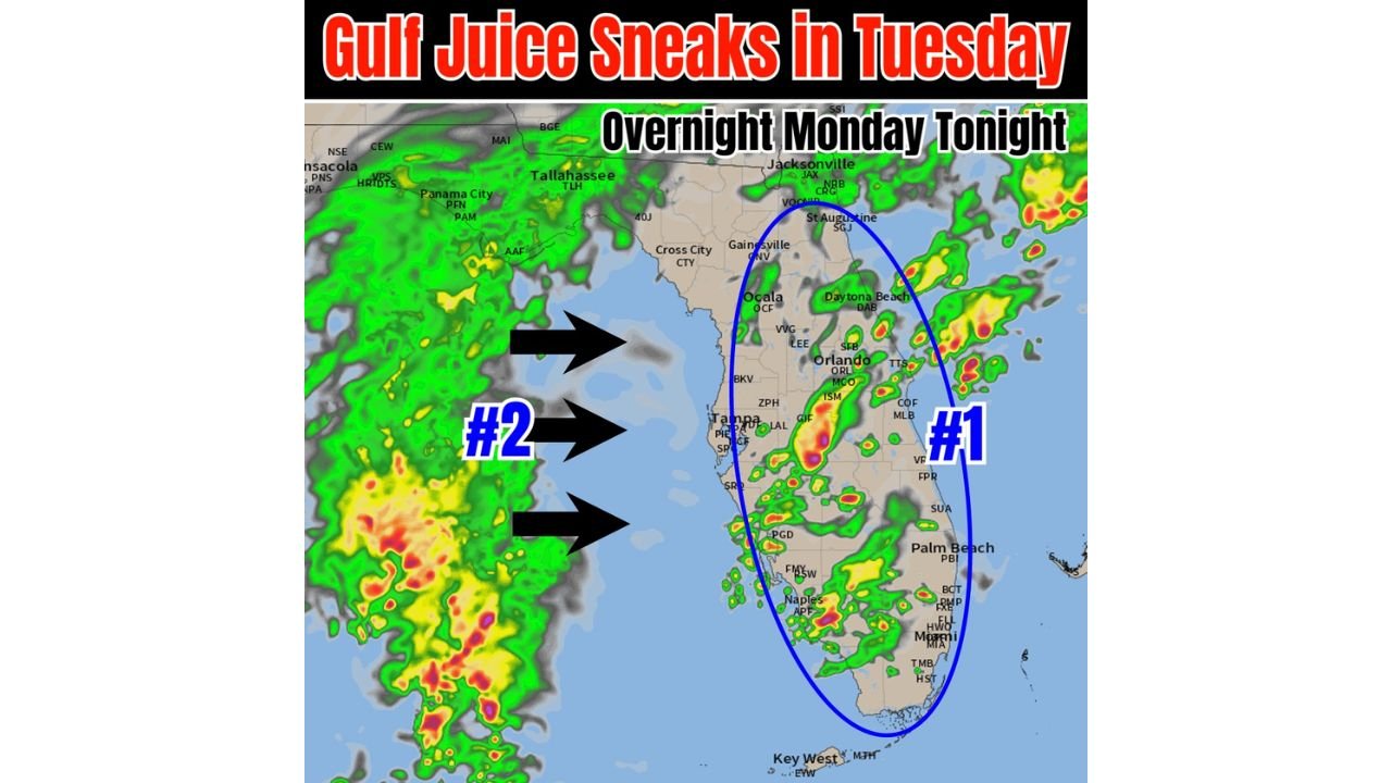
Gulf Moisture Surge Arrives Overnight Monday
The second and more impactful phase begins overnight:
- A surge of deep Gulf moisture (“Gulf juice”) builds from the west
- Moisture moves from the eastern Gulf of Mexico into Florida’s west coast, including areas near Tampa and the Big Bend region
- This system is tied to a frontal boundary enhancing lift and moisture transport
By early Tuesday morning:
- Coastal rain and storms begin developing before sunrise
- Rain bands expand from west to east across the peninsula
Tuesday Expected to Bring the Most Widespread Rain
Tuesday stands out as the most active day in this pattern:
- Widespread rain and thunderstorms likely across much of Florida
- Coverage increases across both coastal and inland areas
- Heavier and more organized rainfall compared to Monday
Key impacts include:
- Periods of steady rain mixed with thunderstorms
- Potential for localized flooding in heavier cells
- Reduced visibility and travel disruptions during peak rain
The west-to-east flow ensures that storm activity spreads across nearly the entire peninsula during the day.
Rain Focus Shifts Toward the East Coast by Wednesday
As the system begins to move out:
- The heaviest rainfall shifts toward Florida’s east coast on Wednesday
- Cities like Jacksonville, Daytona Beach, West Palm Beach, and Miami may still see lingering showers and storms
- Western areas begin to dry out earlier in the day
Even with the shift, scattered rain chances remain across the entire peninsula, though coverage will gradually decrease.
Dry and Pleasant Weather Returns by Late Week
Relief arrives quickly after midweek:
- Rain and storm activity clears out by Thursday and Friday
- A drier and more stable air mass takes over
- Conditions turn more favorable heading into the weekend
Forecast trends suggest:
- Lower humidity
- Reduced rain chances
- More typical springtime conditions returning
What This Means for Florida Residents
Residents across Florida should prepare for:
- Multiple rounds of rain from Monday through Wednesday
- The heaviest and most widespread impacts on Tuesday
- Changing conditions depending on location, especially between west and east coasts
Travel and outdoor plans may be affected during this window, particularly during Tuesday’s peak storm activity.
Stay With Cabarrus Weekly for Florida Weather Updates
As this active weather pattern unfolds, additional updates will track storm timing, rainfall intensity, and regional impacts across Florida.
Stay with Cabarrus Weekly for continued coverage of developing weather systems across the United States.