Florida Timeline Next Week: Slow-Moving Storm System Sets Up Multi-Day Rain Event With Cooler Temperatures and Drought Relief
FLORIDA — A slow-moving weather system is setting the stage for a prolonged stretch of rainfall across much of Florida, bringing a noticeable shift toward cooler temperatures and offering much-needed relief from ongoing dry conditions.
Forecast data shows a developing pattern where a front stalls over the peninsula, allowing rain bands to repeatedly move across the same areas instead of quickly exiting the region.
Rain Bands Begin Building Early in the Week
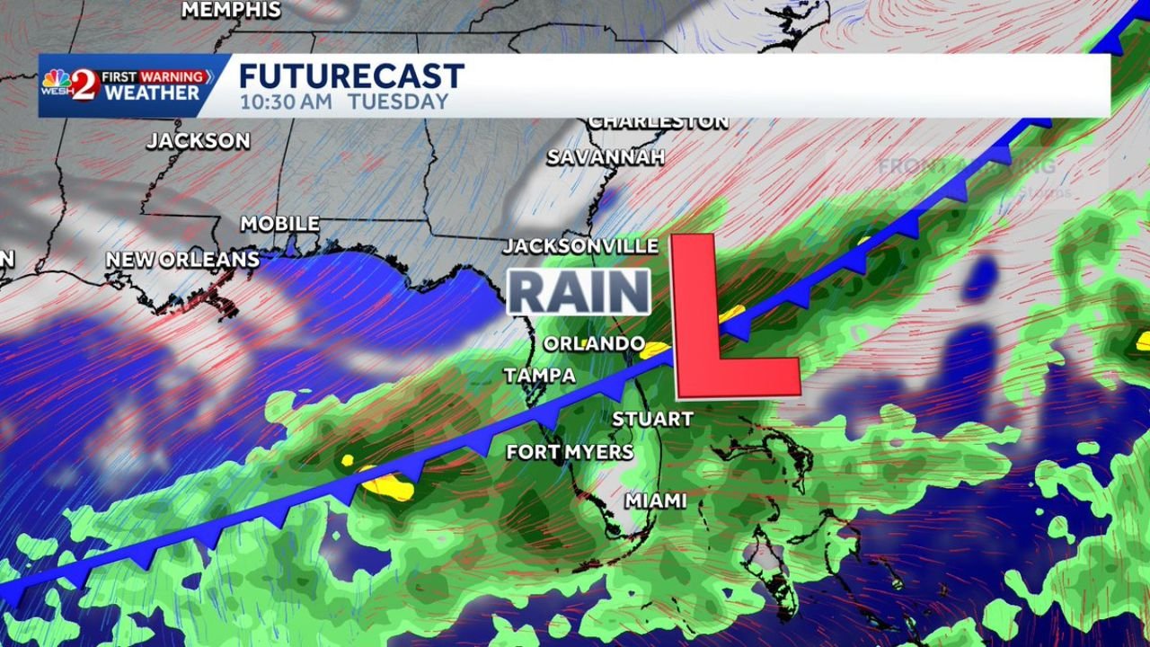
The setup begins with a low-pressure system forming near Florida, with a frontal boundary stretching across central parts of the state.
Cities expected to see early impacts include:
- Orlando
- Tampa
- Jacksonville
- Fort Myers
- Miami
Rain begins to increase as moisture surges northward from the Gulf and Atlantic, creating a widespread zone of precipitation that expands through the day.
Multi-Day Rain Event Could Bring Consistent Showers
Unlike fast-moving storm systems, this setup is expected to linger for several days, meaning repeated rounds of rain are possible.
Key characteristics of this system include:
- Steady rainfall rather than brief storms
- Cloud cover leading to cooler daytime temperatures
- Persistent moisture feeding into the same regions
This type of pattern increases the chance for accumulating rainfall totals over time, even without severe storms.
Rainfall Totals Show Widespread Coverage Across Central Florida
Forecast model comparisons suggest most of central Florida will receive measurable rainfall, with widespread totals generally falling in lower to moderate ranges.
However, both major models indicate:
- Consistent rainfall across Orlando, Sanford, Kissimmee, and surrounding areas
- Potential for slightly higher totals along parts of the east coast, including Daytona Beach and Melbourne
- Uniform coverage rather than isolated pockets
This indicates a broad soaking rain event, not just scattered showers.
Why This Pattern Is Good News for Drought Conditions
The biggest takeaway from this forecast is the potential for gradual drought relief.
Instead of intense, short bursts of rain that quickly run off, this setup favors:
- Slow absorption into the soil
- Improved moisture levels over multiple days
- Reduced stress on vegetation and water systems
While heavy rain in short periods can cause flooding, this steady pattern is more beneficial overall, especially for dry regions.
Cooler Temperatures Add to the Shift in Pattern
Along with rainfall, temperatures are expected to trend cooler than recent days, thanks to:
- Increased cloud cover
- Reduced direct sunlight
- Ongoing precipitation
This will create a noticeable change from recent warmer conditions across Florida.
What to Watch as the System Develops
While the overall setup looks beneficial, a few factors will determine how impactful this event becomes:
- Exact positioning of the stalled front
- How long the low-pressure system lingers near the state
- Whether rain bands repeatedly track over the same locations
If the system slows further, some areas could see locally higher totals than currently projected.
A Wet Pattern Ahead With Long-Term Benefits
This upcoming stretch of weather represents a classic slow-soaker setup, where patience—not intensity—drives the impact.
For many areas across Florida, this could mean:
- Several days of on-and-off rain
- Cooler, more comfortable conditions
- Gradual improvement in drought conditions
Stay Updated With Cabarrus Weekly
For continued coverage on this developing Florida rain event and other major weather patterns across the country, stay connected with Cabarrus Weekly—your trusted source for detailed, data-driven weather reporting.