Florida’s Daytona 500 Could Face Evening Rain Threat as Models Show Storms Moving Across Georgia and Northern Florida
FLORIDA — Forecast models tracking a developing storm system across the Southeast are raising new questions about Sunday evening weather in Daytona Beach, Florida, as rain and thunderstorms spread from Georgia into northern and central Florida.
Latest guidance valid around 7 p.m. Sunday shows a broad area of rain lifting northeast across Alabama and Georgia, with moisture extending into the Florida Peninsula. While the Daytona 500 is still expected to run, the exact timing of the rain could determine whether the later stages of the race are affected.
What the Latest Models Show for Florida, Georgia and Alabama
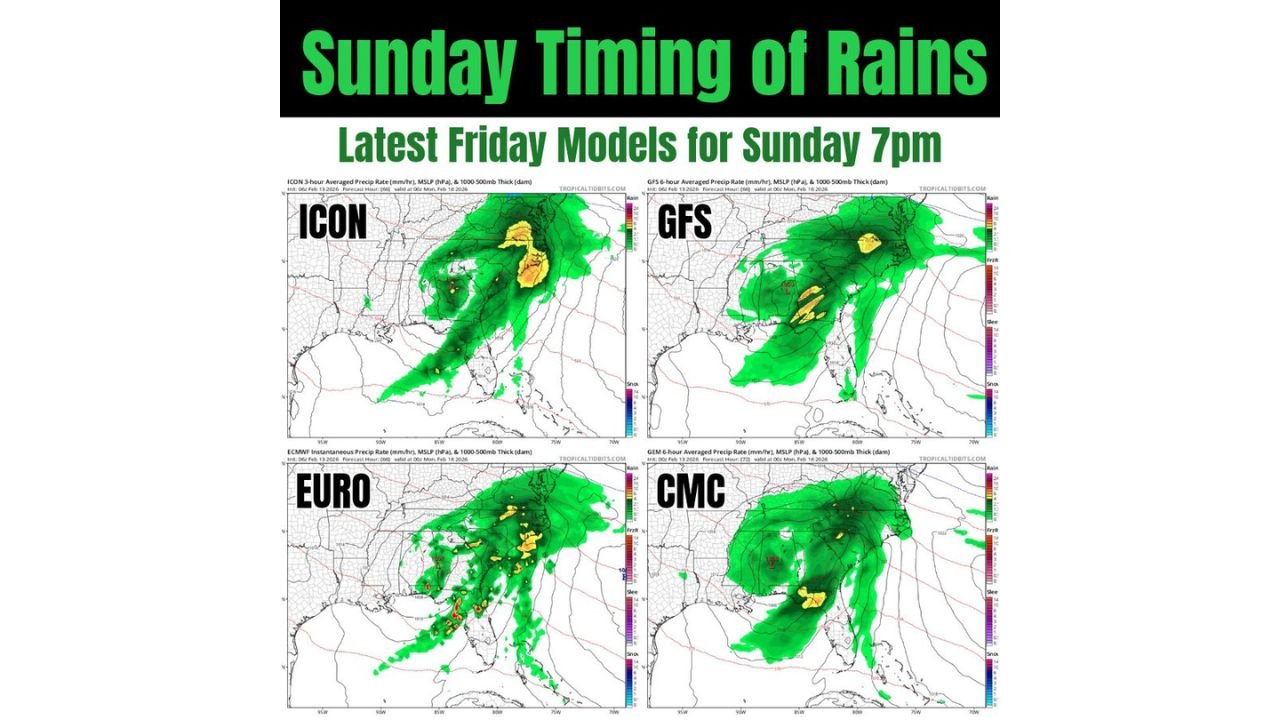
Multiple major forecast models — including the ICON, GFS, EURO (ECMWF), and CMC — agree that a storm system will move through the Southeast on Sunday.
Here’s what stands out:
- A widespread rain shield across Alabama and Georgia
- Bands of heavier rain and embedded thunderstorms within the system
- Moisture expanding southward into northern and central Florida
- The EURO model trending fastest, bringing rain eastward sooner than some other models
The key issue for Daytona Beach is timing. If the faster solution verifies, steadier rain could approach east-central Florida closer to sunset or early evening.
Could Rain Impact the Later Stages of the Daytona 500?
Forecast discussion suggests:
- Some light sprinkles are possible earlier Sunday, but they should not significantly disrupt daytime activities.
- The more organized rain and thunderstorm activity appears later in the day, especially across Georgia and northern Florida.
- Eastern Florida sits near the southern edge of the heaviest precipitation shield — meaning a small timing shift could make a big difference.
If the system slows slightly, most of the race could conclude before heavier rain arrives. If it speeds up, officials may need to monitor radar trends closely as the event progresses.
Why the EURO Model’s Speed Matters
Among the major guidance packages, the EURO continues to show the most aggressive eastward push of rainfall by Sunday evening. That faster movement would:
- Bring rain into eastern Florida sooner
- Increase the chance of showers near Daytona Beach during the later race laps
- Raise the possibility of brief delays if thunderstorms approach
Other models show a similar setup but are slightly slower, keeping heavier rain focused over Georgia and north Florida a bit longer.
Confidence and What Happens Next
Confidence is moderate that rain will impact parts of Alabama, Georgia, and northern Florida on Sunday. The main uncertainty remains exactly how quickly the precipitation shield reaches the east coast of Florida.
At this time:
- A full washout is not expected.
- Light showers are possible earlier in the day.
- The greater rain risk appears later Sunday into the evening.
Race organizers will likely continue evaluating updated model runs before making any timing decisions.
The Bottom Line for Florida
The Daytona 500 in Daytona Beach, Florida is not currently forecast to be canceled, but evening rain timing remains a concern as storms track across Georgia and northern Florida.
If trends hold or slow slightly, the race could run uninterrupted. If storms arrive faster, late-race weather could become a factor.
We’ll continue monitoring updated model guidance and provide new timing details as confidence increases.