From 75° Spring Warmth to 21° Arctic Chill: North Carolina and Midwest Brace for Violent Midweek Storms Before Dramatic Temperature Crash
UNITED STATES — A powerful midweek storm system is set to deliver one of the most dramatic temperature swings of the season, taking parts of the country from springlike warmth in the 70s to wind chills in the low 20s within just 36 hours.
The setup begins Tuesday with unseasonably warm air surging northward across the Ohio Valley and into the Midwest. By Tuesday evening, many areas are forecast to feel like the mid-70s — a May-like preview in early March.
But that warmth will be short-lived.
Tuesday: Spring Preview Across the Midwest and Ohio Valley
Forecast models show apparent temperatures climbing into the 70s across:
- Indiana
- Ohio
- Kentucky
- Illinois
- Missouri
This surge of warmth is being driven by a strong southerly flow ahead of a powerful cold front.
While Tuesday will feel pleasant, it also sets the stage for instability to build — a key ingredient for severe weather.
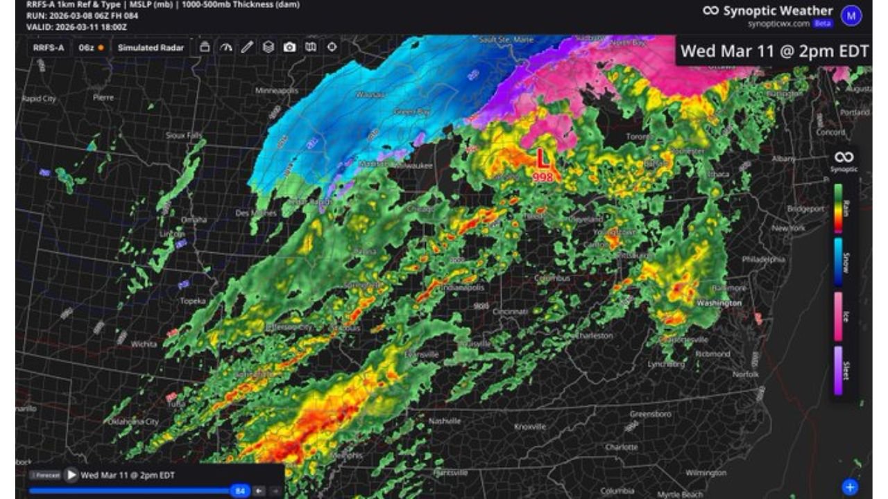
Wednesday: Severe Storm Threat Expands
By Wednesday afternoon, a vigorous storm system will sweep from the Southern Plains through the Midwest and into the Great Lakes.
The Storm Prediction Center outlook highlights a broad severe weather corridor stretching from:
- Texas
- Arkansas
- Missouri
- Illinois
- Indiana
- Ohio
- Into portions of Michigan
An enhanced severe risk area is centered from parts of Missouri into Illinois and Indiana, where damaging winds, large hail, and isolated tornadoes will be possible.
Simulated radar imagery shows a widespread line of thunderstorms pushing northeast, with embedded stronger cells capable of producing severe weather.
Heavy rain will accompany the storms, and strong gradient winds may also develop outside of thunderstorms as the surface low deepens over the Great Lakes.
Rapid Temperature Crash Behind the Front
Once the cold front passes, temperatures will plummet rapidly.
By early Thursday morning, apparent temperatures are forecast to drop into the low 20s across:
- Indiana
- Ohio
- Kentucky
- Illinois
Some areas may even feel colder depending on wind speeds.
This represents a stunning drop of more than 50 degrees in less than two days for some communities.
Rain may briefly mix with or change to snow on the back side of the system in parts of the Great Lakes region as colder air surges in.
Why This Swing Is So Dramatic
Such intense temperature swings occur when:
- A strong warm sector surges north ahead of a deepening low-pressure system
- A powerful Arctic-origin cold front barrels southward behind it
- Tight pressure gradients increase wind speeds, enhancing wind chill
The combination of severe storms followed by near-winter conditions makes this a high-impact system.
What This Means Going Forward
Residents across the Midwest and Ohio Valley should prepare for:
- Potential severe weather Wednesday
- Strong winds with the frontal passage
- A rapid and uncomfortable temperature drop into Thursday
These kinds of dramatic swings are not uncommon in early spring, but this one stands out due to the magnitude of the change.
CabarrusWeekly.com will continue monitoring developments as this powerful system moves across the country and delivers both severe weather and a sharp return to winter-like conditions.