Georgia, Alabama, Mississippi, Florida and the Carolinas Face 10–20 Degree Temperature Surge With Near 90°F Heat by Friday
UNITED STATES — A sharp temperature swing is setting up across the Southeast this week, with a brief midweek cooldown quickly giving way to a significant surge of warmth that could push temperatures into near-summer levels by Friday.
Midweek Cooldown Brings Temporary Relief
A passing frontal system will briefly interrupt the warm pattern early in the week, bringing:
- Cooler air dropping highs into the 60s and 70s
- A short-lived reset following recent warmth
- More seasonable conditions for a couple of days
This cooldown, however, is not expected to last long.
Strong High Pressure Ridge Drives Rapid Warm-Up
By late week, a dominant ridge of high pressure will build across the southeastern United States, setting the stage for a rapid temperature rebound.
This pattern will:
- Promote clear skies and strong solar heating
- Limit cloud cover and precipitation
- Allow temperatures to rise quickly over just 24–48 hours
The result will be a dramatic shift from mild conditions to early-season heat.
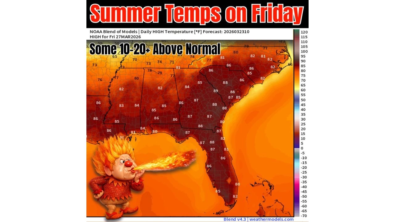
Temperatures Jump 10–20 Degrees Above Normal
Forecast guidance shows widespread warming by Thursday into Friday, with temperatures climbing well above seasonal averages.
Expected highs include:
- 80s across much of the Southeast interior
- Upper 80s to near 90°F in the Deep South
This represents 10 to 20+ degrees above normal, which is significant for late March and could challenge a few daily records.
Inland Areas Feel the Heat Most
The warmest conditions will be focused across:
- Interior sections of Alabama, Georgia, Mississippi, and the Carolinas
- Regions farther from coastal influences where heating is strongest
These areas will experience the most pronounced departure from normal temperatures.
Coastal Regions Slightly Moderated
While still warm, coastal areas will see somewhat lower temperatures due to:
- Atlantic sea breezes along the East Coast
- Gulf moisture influencing southern coastal zones
Even with this moderation, temperatures will remain above average across nearly the entire Southeast.
A Classic Spring Temperature Whiplash
This setup highlights a classic springtime pattern where:
- A cold front briefly cools conditions
- High pressure quickly rebuilds behind it
- Temperatures surge well above normal in a short period
Such rapid swings are typical during the transition from winter to summer, but the magnitude of this warm-up is particularly notable.
Potential For Record-Challenging Heat
With highs nearing 90°F in some locations:
- A few record highs may be tied or broken
- The region will experience one of its earliest widespread heat episodes of the year
This kind of warmth arriving in March signals an early preview of summer-like conditions.
Final Outlook
After a short-lived cooldown, the Southeast is set to experience a powerful late March heat surge, with temperatures soaring 10 to 20 degrees above normal by Friday and some areas approaching 90°F.
The rapid shift from mild to hot conditions underscores how quickly spring weather patterns can evolve across the United States.
Stay with CabarrusWeekly.com for continued coverage of major weather changes impacting the country.