GFS and Euro Models Signal Potential 70°+ Surge in Week 2 of March, Raising Ice Jam and Flood Concerns in New England
NEW ENGLAND — Long-range forecast models are now signaling a sharp warm-up during the second week of March, with both the GFS and European (ECMWF) guidance showing daytime highs potentially surging into the 70s for several consecutive days.
While springlike warmth may sound appealing after weeks of winter, meteorologists caution that a rapid temperature spike could create significant hydrological concerns, particularly in areas with deep snowpack and ice-covered rivers.
Both Major Models Showing 70s
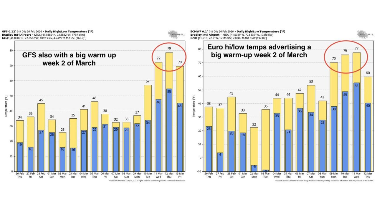
The latest temperature projections from both global models indicate a dramatic climb beginning around the second week of March.
According to the European model:
- Highs could reach around 70°F
- Additional days near 76–77°F
- Overnight lows rising into the upper 40s to mid-50s
The GFS model is even more aggressive:
- Highs near 72°F
- A peak around 79°F
- Additional days hovering around 70°F
If these numbers verify, it would represent a rapid transition from late-winter chill to early-spring warmth in just a matter of days.
Why This Warm-Up Is Concerning
The primary issue isn’t the warmth itself — it’s the speed and combination of factors that may accompany it.
A sudden push into the 70s could:
- Accelerate snowmelt
- Increase runoff into rivers and streams
- Break apart river ice, leading to ice jams
- Raise the risk of localized flooding
If rainfall accompanies the warm surge, the flood threat would increase further.
With many rivers still ice-covered and snowpack lingering across interior New England, the region is particularly vulnerable to rapid melt scenarios.
Mitigating Factors Still in Play
Forecasters note several important caveats:
- Long-range warm-ups are often overdone in late winter
- Ensemble averages currently show temperatures more in the low 60s, still mild but less extreme
- March frequently brings “backdoor cold fronts” that can quickly knock temperatures down
New England’s coastal geography often allows cooler marine air to undercut warmer inland surges.
In short, there is still considerable time for adjustments in the forecast.
Heavy Snowpack Raises the Stakes
What makes this potential warm-up more notable this year is the existing snow and ice coverage.
Deep snowpack combined with frozen ground conditions can limit infiltration, meaning meltwater runs off quickly into rivers.
When river ice begins to break apart, chunks can pile up at bends or constrictions, forming temporary dams that cause water levels to spike upstream.
This dynamic makes gradual warming far preferable to a sudden temperature jump.
Plenty of Time to Watch the Trend
It’s important to emphasize that this scenario remains in the long-range window, and forecast adjustments are likely in the coming days.
Forecasters will continue monitoring:
- Temperature trend consistency between models
- Rainfall potential during the warm surge
- River and ice conditions
- Signs of backdoor cold fronts interrupting the warm-up
While many would welcome 70-degree weather in early March, a slower and steadier thaw would reduce the risk of ice jams and flooding.
Stay with CabarrusWeekly.com for continued weather updates as models refine the outlook.