GFS Hints at Strong Storm System Next Week With Possible Severe Weather Setup for the Southeast and Carolinas
SOUTHEASTERN UNITED STATES — Long-range guidance from the GFS model is beginning to suggest the possibility of a strong storm system developing next week, with some potential for severe weather across portions of the Southeast. While confidence remains low at this range, the signal is notable enough to warrant early attention—especially as key ingredients appear to be returning to the pattern.
Forecasters stress that this is not a locked-in forecast, but rather an early look at a setup that could evolve as more reliable data becomes available.
GFS Shows Organized Upper-Level System Taking Shape
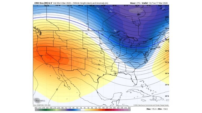
The GFS 500mb height and wind speed maps show a well-defined trough digging into the central and eastern United States, with strong upper-level winds wrapping around the system. This type of configuration often supports organized surface development when other ingredients align.
The model depiction shows a powerful jet streak extending across the eastern half of the country, a feature that can enhance lift and storm organization if surface moisture and instability are present.
At this point, forecasters describe the output as “eye candy”—a visually impressive signal that still requires confirmation from future model runs.
Moisture Return Signals Appear Across the Gulf and Southeast
Dew point projections from the GFS show noticeable moisture return from the Gulf of Mexico, with 60+ degree dew points extending northward into parts of the Deep South and Southeast.
This moisture axis includes Louisiana, Mississippi, Alabama, Georgia, and parts of the Carolinas, a key ingredient for any severe weather setup. Farther north, drier air remains entrenched, reinforcing the idea that the severe threat—if it materializes—would be focused farther south.
The placement and timing of this moisture surge will be critical in determining whether storms can intensify.
Why Severe Weather Is Only a “Some” Potential Right Now
Despite the promising large-scale structure, forecasters remain cautious. Several factors are still uncertain, including:
- Exact timing of the upper-level system
- Strength and placement of surface low pressure
- How far north instability can advance
- Whether wind shear and moisture overlap at the right time
Because this is still well beyond the reliable forecast window, confidence in specific impacts remains low. Small shifts in the pattern could either enhance the threat—or eliminate it altogether.
What This Could Mean for the Carolinas
For the Carolinas, including North Carolina, this setup bears watching but does not yet justify alarm. If future model runs maintain the signal, the region could see a period of strong to potentially severe storms, depending on how the system evolves.
At this stage, the most realistic takeaway is awareness—not action. Severe weather threats at this range often change dramatically as higher-resolution guidance becomes available.
Why Forecasters Are Watching the Pattern Closely
What makes this setup stand out is not a single model run, but the return of a more active, energetic pattern after recent quieter stretches. Strong upper-level flow, Gulf moisture availability, and a defined trough are classic ingredients—but they must align precisely.
Forecasters will be watching for consistency across multiple model cycles before increasing confidence or messaging any specific threats.
Bottom Line for Now
There is no immediate severe weather threat confirmed for next week, but early GFS guidance hints at a system worth monitoring, especially across the Southeast and Carolinas. Confidence remains low, and significant changes are still possible.
CabarrusWeekly.com will continue tracking this evolving pattern and provide updates as confidence increases and newer data comes into focus.