Growing Severe Weather Risk Tuesday April 14 Targets Plains And Midwest From Oklahoma And Kansas Through Missouri Illinois Iowa And Wisconsin With Damaging Winds Large Hail And Tornadoes Possible
UNITED STATES — Confidence is growing in a significant severe weather threat for Tuesday, April 14, 2026, as a strengthening storm system pushes a dangerous corridor of severe storms from the Southern Plains northeastward through the Midwest. Scattered to numerous severe storms will be capable of damaging winds, large hail, and tornadoes across a large and heavily populated region.
Storm Track: Oklahoma And Kansas Into The Heart Of The Midwest
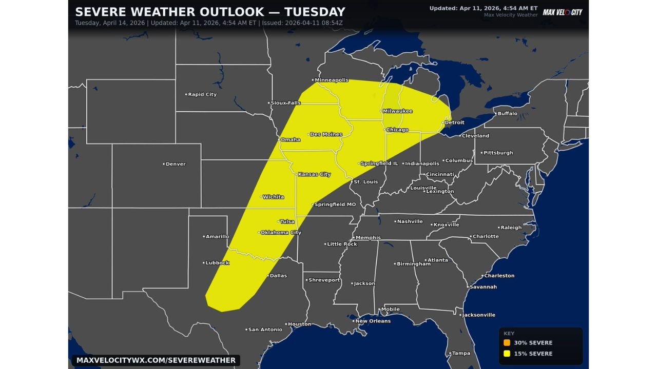
Thunderstorms are expected to develop along a strengthening low-pressure system and push northeast throughout the day Tuesday, carving out a dangerous path from Oklahoma and Kansas into Missouri, Illinois, Iowa, and Wisconsin. The risk zone as depicted in the Tuesday Severe Weather Outlook covers a massive corridor including:
- Oklahoma City and Tulsa in the south
- Wichita and Kansas City through the central Plains
- Omaha, Des Moines, and Sioux Falls across the northern Plains
- Springfield MO and St. Louis in Missouri
- Springfield IL, Chicago, and Milwaukee through Illinois and Wisconsin
- Minneapolis at the northern edge of the risk zone
- Indianapolis and Columbus on the eastern fringe
Organized Tornado Threat Possible In The Midwest
While damaging winds and large hail will be widespread threats Tuesday, forecasters are particularly concerned about the tornado potential across the Midwest during the afternoon and evening hours. Strong wind shear is expected to become a key factor as the day progresses, potentially allowing storms to organize into discrete supercells capable of producing tornadoes.
A more organized tornado threat may develop across the Midwest specifically, where the combination of deep moisture, strong instability, and increasing wind shear creates the most favorable environment for tornado-producing supercells during the afternoon and evening.
Severe Weather Outlook At A Glance
The Max Velocity Weather Severe Weather Outlook for Tuesday April 14, updated at 4:54 AM ET on April 11, 2026, shows the following risk breakdown:
- 15% Severe probability — covering the broad risk corridor from Texas through the Upper Midwest, indicating a widespread and significant severe weather threat across the entire zone
- The risk area stretches from Dallas and Houston in the south all the way to Minneapolis and Milwaukee in the north — one of the largest geographic risk footprints of the entire multi-day severe weather stretch
Confidence Growing Despite Forecast Uncertainty
Forecasters note that while details will continue to evolve as Tuesday’s setup comes into better focus over the coming days, confidence is steadily growing in a fairly active and organized severe weather scenario across a large region. The overall pattern strongly supports:
- Scattered to numerous severe storms developing and pushing northeast through the day
- A large geographic area facing meaningful severe weather potential
- The potential for organized severe weather rather than isolated, scattered activity
Be Prepared Now If You Live In The Risk Zone
If you live anywhere from Texas and Oklahoma northward through Kansas, Missouri, Iowa, Illinois, Wisconsin, and into Minnesota, Tuesday is a day to take seriously. Steps to take now:
- Monitor forecasts daily as details sharpen heading into Tuesday
- Have your severe weather shelter plan identified well in advance
- Keep weather alert notifications active on all devices
- Be prepared for rapidly changing conditions throughout Tuesday afternoon and evening
Stay with CabarrusWeekly.com for continuing coverage of Tuesday’s growing severe weather threat across the Plains and Midwest as this dangerous pattern continues to develop.