Heavy Snow Bands Target Pennsylvania as 1–2 Inch-Per-Hour Rates Threaten Travel From Morning Through Afternoon
PENNSYLVANIA — Forecasters are warning of dangerous, high-impact snowfall across large parts of Pennsylvania on Sunday, with intense snow bands expected to produce 1 to 2 inches of snow per hour for several consecutive hours, dramatically reducing visibility and making travel extremely hazardous from late morning through the afternoon.
Two Distinct Heavy Snow Zones Expected Across the State
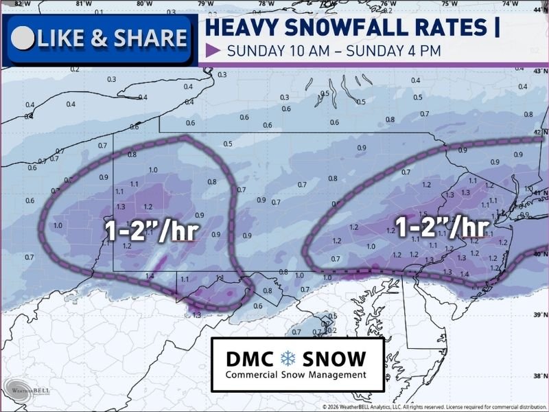
Meteorologists are closely monitoring two primary areas where snowfall rates are expected to peak. The first zone is developing across southwestern Pennsylvania, tied directly to the storm’s primary surface low. This area is expected to see sustained heavy snow as the system strengthens and tracks eastward.
The second — and potentially more intense — zone is forecast across eastern Pennsylvania, where strong frontogenesis is expected to drive tightly packed snowfall bands. Forecasters say this region could briefly experience snowfall rates exceeding 2 inches per hour, especially within the most persistent bands.
Timing: Late Morning Through Sunday Afternoon
The most dangerous conditions are expected from approximately 10 a.m. through 4 p.m. Sunday, when snow bands are forecast to be most organized and intense. During this window:
- Visibility may drop to near zero at times
- Roads and interstates will quickly become snow-covered and snow-packed
- Travel conditions may deteriorate faster than plows can respond
Cold Temperatures Will Worsen Road Conditions
Temperatures across Pennsylvania are expected to remain in the single digits to teens, ensuring that all precipitation remains snow. These cold conditions will prevent melting and allow snow to accumulate rapidly on major highways, secondary roads, bridges, and ramps.
Because of the fluffy but fast-accumulating nature of the snow, even treated roadways may become slick and impassable in short periods of time.
Travel Strongly Discouraged Except for Emergencies
Forecasters are issuing a blunt warning to residents in the hardest-hit areas:
Do not travel unless it is for emergency or essential work purposes.
Heavy snowfall rates combined with low visibility and cold pavement temperatures create a high risk for spin-outs, crashes, and stranded vehicles. Officials stress that no routine trip is worth risking lives under these conditions.
What Residents Should Do Now
Pennsylvania residents in both western and eastern parts of the state are urged to:
- Complete errands before snow intensifies
- Avoid unnecessary travel during peak snowfall hours
- Keep emergency supplies and charged devices on hand
- Monitor local alerts and road restrictions closely
This storm is shaping up to be one of the most disruptive snow events of the season for Pennsylvania, not because of total snowfall alone, but due to how fast the snow will fall during the most dangerous hours of the day.
Stay with CabarrusWeekly.com for continued regional weather coverage, storm updates, and safety information as this winter system unfolds.