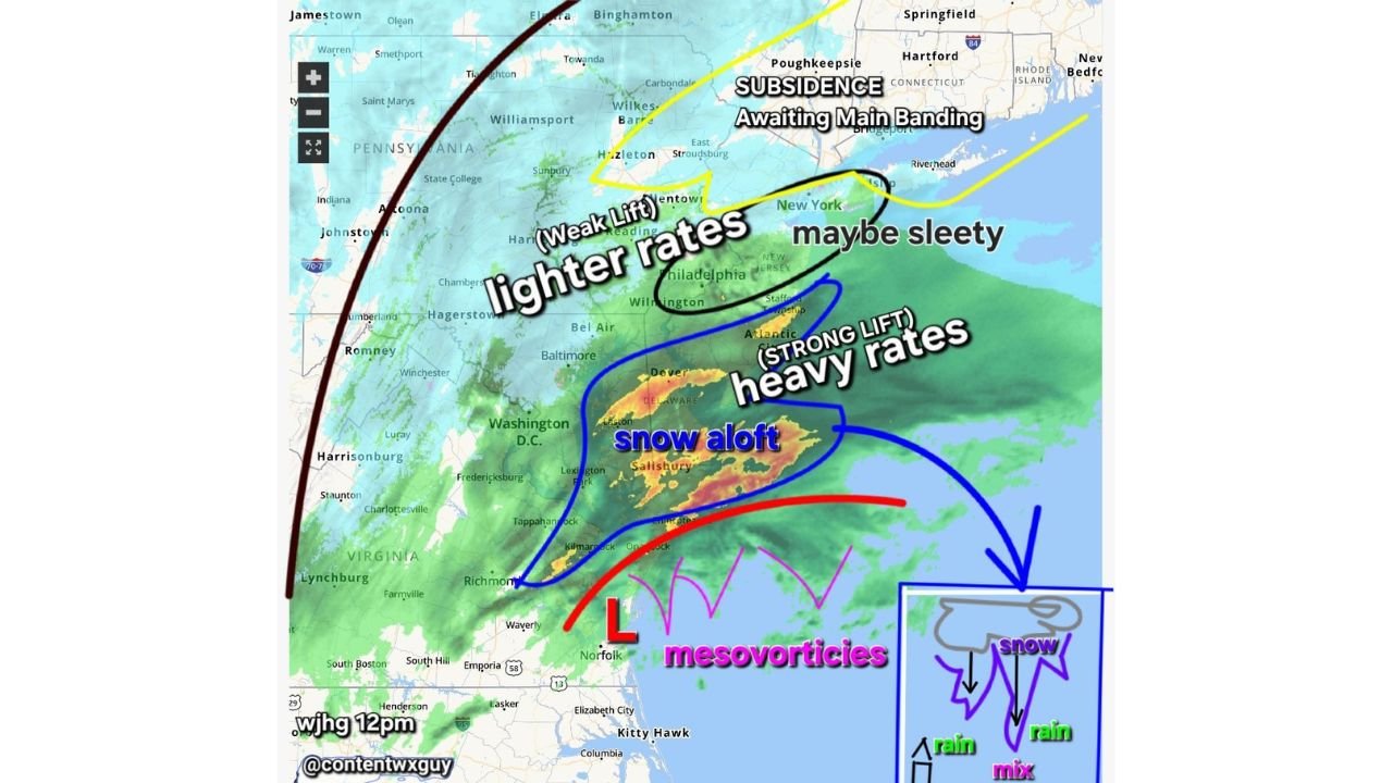
Heavy Snow Developing Aloft Over Delaware and New Jersey as Intensifying Coastal Low Spins Up Mesovortices East of Norfolk
MID-ATLANTIC COAST — Bright radar echoes across parts of Delaware, southern New Jersey, and eastern Maryland are signaling something important: heavy snowfall is developing aloft — not rain — as a strengthening coastal low continues to intensify offshore.
Meteorologists analyzing midday radar imagery note that while radar remains in rain mode, the brightest returns are actually associated with snow falling in the upper levels of the atmosphere, with colder air gradually working downward.
Snow Is Changing Over from the Top Down
Unlike a typical rain-to-snow changeover that happens as a surface cold front sweeps through, this setup is different.
Forecasters explain:
- The cold air is filtering in from above.
- Snow is forming aloft first.
- The lower atmosphere cools gradually until precipitation flips fully to snow.
That means communities in parts of Delaware, southern New Jersey, and coastal Maryland may see a faster-than-expected transition once the column cools completely.
You are not waiting on a traditional “mix line” to move in — the changeover happens vertically.
Heavy Snow Rates Where Lift Is Strongest
The radar presentation shows a distinct zone of strong lift near and north of the low center, especially across:
- Central and southern Delaware
- Southern New Jersey
- Coastal Maryland near Salisbury
These areas are seeing the most intense echoes, suggesting heavy snowfall rates once the transition completes.
Farther north toward Philadelphia and into northern New Jersey, lift appears weaker, supporting lighter snowfall rates and even pockets that may briefly mix with sleet.
Mesovortices Developing East of the Low
Just east of the low center, near the Virginia coast and offshore waters, meteorologists are identifying developing mesovortices — small-scale rotating features embedded within the larger storm circulation.
These can:
- Enhance localized wind gusts.
- Produce brief but intense snow bursts.
- Increase the chance of coastal waterspouts.
High winds are often “core producers” in these setups, meaning the strongest gusts typically occur near the most dynamically active portions of the storm.
Subsidence North of Main Band
Across parts of eastern Pennsylvania and the Lower Hudson Valley, a zone of subsidence — sinking air — is temporarily limiting snowfall intensity. However, forecasters caution that main banding could redevelop and shift.
What This Means for Cabarrus County
For Cabarrus County and central North Carolina, the storm’s most intense dynamics remain well to the north and offshore.
Locally:
- No snowfall impacts are expected.
- Breezy conditions may develop as pressure gradients tighten.
- Cooler air may filter south behind the system.
While the heaviest impacts remain across the Mid-Atlantic and Northeast, rapidly strengthening coastal lows can briefly influence regional wind patterns.
A Dynamic and Evolving Coastal Storm
With heavy snow developing aloft, strong lift zones over Delaware and southern New Jersey, and mesovortices spinning east of the low near Virginia’s coast, this system remains highly dynamic.
Forecasters will continue watching for:
- Rapid snowfall rate increases.
- Strong coastal wind gusts.
- Additional band development.
Cabarrus Weekly will continue tracking the storm’s evolution and any downstream weather changes that could affect North Carolina.
Stay with CabarrusWeekly.com for continued weather updates and local coverage.