High-Impact Saturday Snowstorm Takes Shape With 4–8 Inches Likely, All-Snow Setup, and Lingering Road Problems Into Next Week
UNITED STATES — Confidence continues to increase in a high-impact snowstorm expected to unfold Saturday, bringing steady snowfall from early morning through early evening, with heavy snow at times and conditions cold enough to keep snow on the ground well into next week.
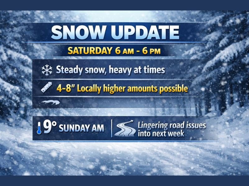
Steady Snow Expected From Morning Through Evening
Midday model guidance supports a long-duration snow event, with snow developing by around 6 AM Saturday and continuing through approximately 6 PM. Snowfall is expected to be persistent, not showery, which significantly increases accumulation potential and travel impacts.
Forecasters emphasize that this is a classic snow-producing system, not a marginal setup that flips between rain, sleet, and snow.
Widespread 4–8 Inches With Locally Higher Totals
Most areas under the core of this system are currently projected to receive 4 to 8 inches of snow, with some locations likely ending up higher depending on banding and snowfall intensity. The consistency of snowfall throughout the day favors efficient accumulation, especially on untreated roads.
Because the event lasts much of the day, even moderate hourly rates will stack up quickly.
All Snow, Not Ice — But Cold Will Be a Problem
The good news is that this storm is expected to be all snow, with no significant ice threat indicated in current data. That reduces the risk of power outages but does little to ease travel concerns.
The downside is the cold. Wind chills in the teens and a low near 9 degrees Sunday morning mean melting will be minimal. Snow that falls Saturday is expected to stick around, especially on secondary roads and shaded areas.
Roads Likely to Remain Hazardous Into Next Week
With temperatures staying cold after the storm, road conditions may not fully improve for several days. Compacted snow and refreeze issues could linger into early next week, even after snowfall ends.
Drivers should plan for extended travel disruptions, not just during the storm itself but in the days following.
What to Expect Overall
This is shaping up to be a play-in-the-snow type of storm for kids and families—but a difficult situation for transportation and daily routines. The combination of steady snowfall, cold temperatures, and long-lasting impacts makes this a storm to take seriously.
More refinements to snowfall totals and timing are expected, but overall confidence in a significant Saturday snow event continues to grow.
If you experience heavy snow, slick roads, or unusually cold conditions this weekend, share what you’re seeing. Stay connected with CabarrusWeekly.com for ongoing updates, forecast refinements, and winter weather coverage.
Author: Cabarrus Weekly Weather Desk | Category: Weather