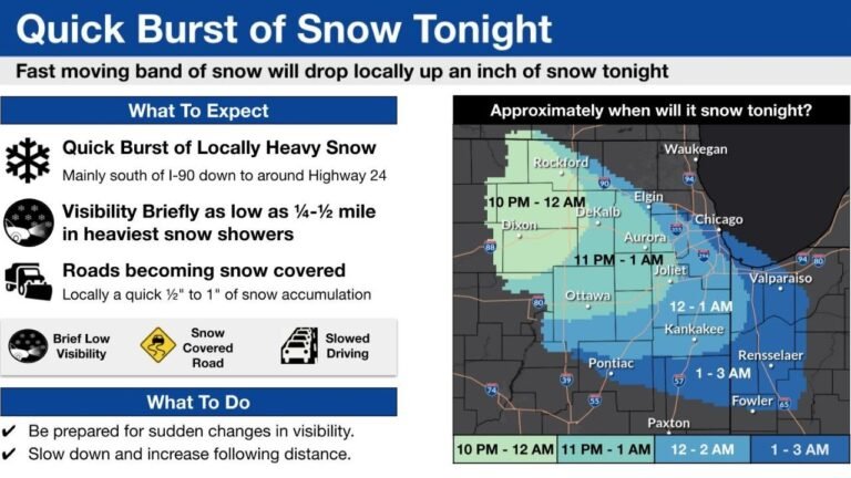
High-Impact Snowstorm Possible for Upstate New York and New England Late Next Weekend, but Fragile Atmospheric Setup Could Still Derail the Event
NORTHEASTERN UNITED STATES — A new 12z European model run is drawing attention for depicting a potentially significant snowstorm across upstate New York and parts of New England during the back half of next weekend, though forecasters caution that the atmospheric setup remains delicate and could still unravel.
European Model Shows Snow Potential but With Limited Margin for Error
The latest guidance highlights an impressive snow signal for portions of the interior Northeast, particularly upstate New York and higher elevations of New England. However, meteorologists stress that this is a classic “thread-the-needle” scenario, where multiple atmospheric features must align precisely for heavy snow to materialize.
At this range, confidence remains low in exact outcomes, even though the storm signal itself is becoming clearer.
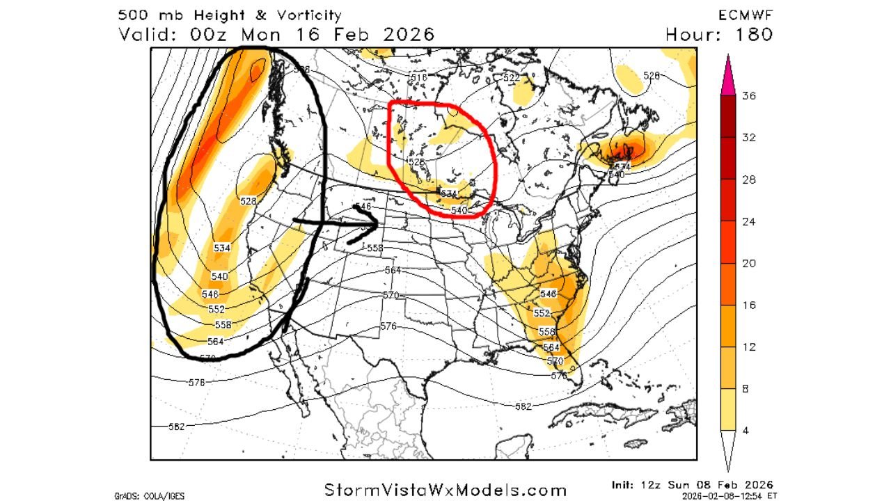
Pacific Energy Slamming the West Coast Creates Structural Challenges
One of the biggest obstacles to a high-end East Coast snowstorm is a large batch of Pacific energy crashing into the West Coast during the same time frame. This strong, fast-moving energy pushes east across the continent, preventing the development of a robust ridge over the western United States.
Historically, many major East Coast snowstorms rely on a strong western ridge near the Rockies to force energy to dig south and slow down. Without that ridge in place, storms tend to move faster and struggle to fully intensify.
Missed Phasing Limits Storm Ceiling in Current Runs
Even in the European run that produces heavy snow, forecasters note a key limitation. Energy over central Canada that could help strengthen the storm is not forced far enough south, due to weaker heights over Alberta and Saskatchewan.
If that northern energy were to dive southeast more aggressively, it would likely do several important things:
intensify the storm, slow its forward motion by promoting a mid-level cutoff, and inject colder air into the system. Without that interaction, the storm’s maximum potential remains capped.
Borderline Temperatures Along the I-95 Corridor
Temperature profiles present another major challenge, especially for I-95 corridor cities. While this winter has featured frequent cold air in the East, current projections do not show a strong Arctic high pressure system anchored over Quebec during this event.
The lack of a dominant cold high allows milder air to linger near the coast, raising the risk of rain or mixed precipitation instead of snow for major metro areas. Interior locations remain more favorably positioned for snow if the storm holds together.
What Would Improve Snow Chances in the Northeast
For snow lovers, the most favorable adjustment would be slower Pacific energy by roughly 24 hours. That delay would give familiar winter features one last opportunity to re-establish themselves, including a ridge in the West and stronger cold air over eastern Canada.
One factor that models do agree on is the presence of a strong disturbance emerging from the central United States, which is expected to tap into Gulf moisture. That alone ensures the Northeast at least has a chance at a significant storm, even if details remain unresolved.
Forecast Confidence Remains Low but Worth Monitoring
While the ingredients for a major winter storm are present, the margin for error is extremely small, and minor timing changes could drastically alter outcomes. Forecasters emphasize that details should remain murky for several more days, with clearer signals expected as the event moves into shorter-range guidance.
If you live in upstate New York or New England and are watching this potential storm closely, we want to hear from you. Share what you’re seeing and stay up to date with evolving forecasts at CabarrusWeekly.com.