High Pressure Over Canada Locks In Cold Air as Friday Snowstorm Targets Interior New England With Several Inches Possible
INTERIOR NEW ENGLAND — A developing late-week storm system could bring a swath of accumulating snow across much of interior New England on Friday, as strong high pressure over Canada funnels just enough cold air south to keep precipitation falling as snow.
Forecast guidance indicates the most significant accumulation potential will stay inland, away from immediate coastal influences.
Canadian High Pressure Supplying Cold Air
Surface pressure anomaly maps show a robust high centered over eastern Canada, extending into Quebec and northern New England. This feature is critical in maintaining low-level cold air across the interior.
At the same time, a developing low-pressure system tracks across the eastern United States, drawing moisture northward into the colder air mass.
The positioning of that Canadian high helps prevent warm air from surging too far inland, increasing confidence that interior areas remain predominantly snow.
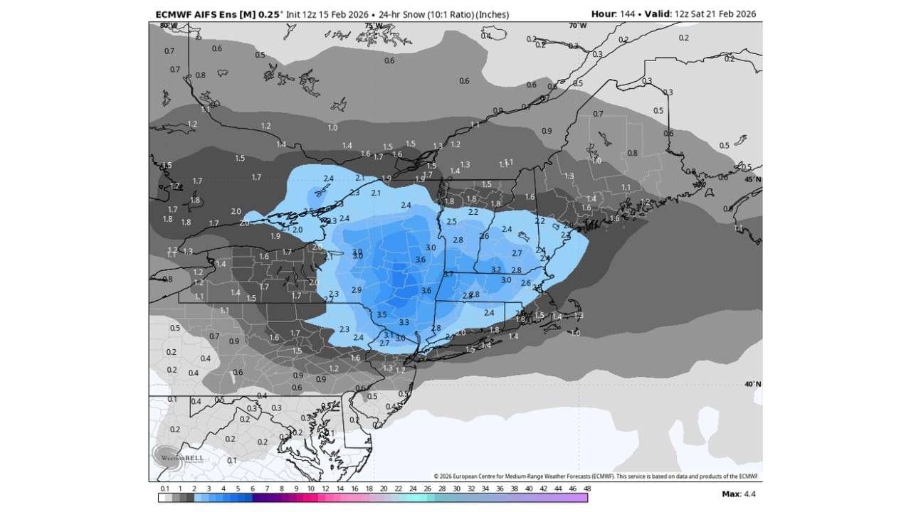
Storm Track Favors Interior Accumulation
Model projections suggest the primary snowfall axis stretches across:
- Central and western Massachusetts
- Interior Connecticut
- Southern Vermont
- Southern New Hampshire
- Upstate New York
Snowfall projections show widespread totals in the 2 to 4 inch range, with localized pockets possibly exceeding that in elevated terrain.
The highest probabilities for consistent accumulation appear from the Hudson Valley eastward through central Massachusetts and into southern New Hampshire.
Coastal Areas May See Lower Totals
Closer to the coast — including eastern Massachusetts and portions of Rhode Island — slightly milder air may limit totals or introduce mixing concerns. However, even some coastal communities could still see light accumulation depending on exact storm track and timing.
The interior remains the primary zone for steadier snowfall rates.
Timing and Impacts
Current projections place the most impactful snowfall during the day Friday, potentially affecting travel across major inland corridors including:
- I-90 (Mass Pike)
- I-91
- I-89
- Portions of I-84
Snowfall rates do not currently appear extreme, but steady accumulation during daytime hours could create slick roads and slower travel conditions.
Still Worth Monitoring
While guidance shows a coherent signal for accumulating snow inland, small shifts in storm track or intensity could alter snowfall amounts. Snow events in New England are highly sensitive to temperature gradients and coastal influences.
At this time, the setup supports a solid interior snow event, with Canadian high pressure supplying just enough cold air to keep the system predominantly snow for many inland communities.
Residents across interior New England should monitor forecast updates as details on exact totals and timing become clearer.
If snowfall begins in your area Friday, share your reports and photos with CabarrusWeekly.com as this late-week winter setup develops.