High Severe Weather Probability Corridor From Texas to Ohio Valley: Deep South and Mid-South Face Elevated Risk Stretching Toward the Great Lakes
UNITED STATES — A broad and concerning corridor of elevated severe weather probabilities is setting up from southeast Texas through Louisiana, Mississippi, Alabama, Tennessee, Kentucky, Indiana, Ohio, and into southern Michigan, signaling a multi-state severe weather risk.
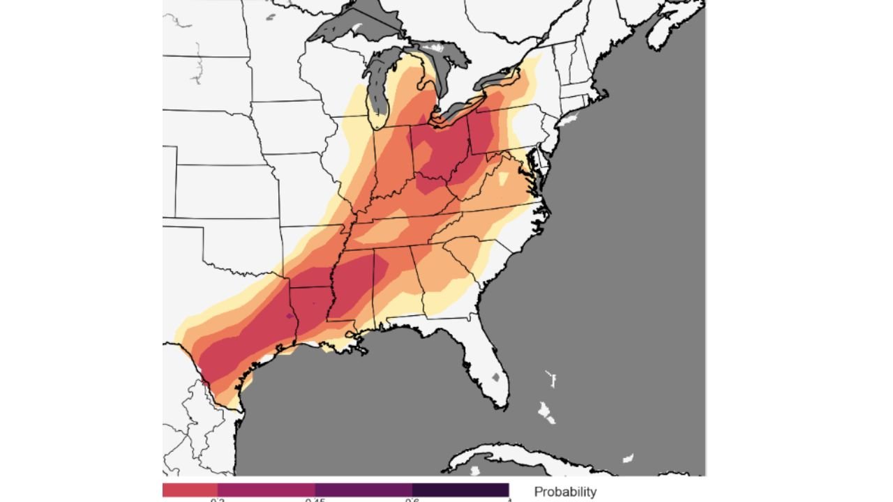
The probability map shows a pronounced axis of higher values (highlighted in deeper red and magenta shading) beginning near the upper Texas Gulf Coast, extending northeast through the Lower Mississippi Valley, across the Tennessee and Ohio Valleys, and reaching toward parts of the southern Great Lakes region.
Where the Highest Probabilities Are Located
The most intense probability shading appears focused across:
- Southeast Texas near the Gulf Coast
- Southern and central Louisiana
- Central and northern Mississippi
- Western and central Tennessee
- Kentucky
- Southern Indiana and Ohio
- Southern Lower Michigan
This alignment suggests a classic southwest-to-northeast severe weather track often associated with strong spring storm systems.
What the Corridor Indicates
A probability corridor of this magnitude and geographic length typically points to:
- Widespread thunderstorm development
- Organized storm clusters or supercells
- Potential for damaging winds
- Large hail risk
- Tornado potential in favorable zones
The fact that the highest probabilities extend from the Gulf Coast into the Midwest suggests a well-organized system with strong upper-level support and a robust moisture return from the Gulf of Mexico.
Deep South to Ohio Valley Focus
The Deep South — including Louisiana, Mississippi, and Alabama — often experiences enhanced severe weather risk when Gulf moisture interacts with strong wind fields aloft.
As storms track northeast, the environment across Tennessee, Kentucky, Indiana, and Ohio appears supportive of continued severe potential. The extension into southern Michigan indicates the system will remain dynamic even as it moves northward.
This type of elongated risk zone frequently supports:
- Early development in the southern tier
- Strengthening storms across the Mid-South
- Continued severe potential into the Ohio Valley
What This Means for Residents
Given the wide coverage area, this does not appear to be a highly localized event. Instead, it suggests:
- Multiple rounds of storms may occur
- Impacts could be spread across several states
- Travel disruptions are possible across a large portion of the central and eastern U.S.
Residents across the highlighted corridor should monitor updated forecasts, especially in the higher-probability shaded regions.
CabarrusWeekly.com will continue to track developments as this expansive severe weather setup evolves across the southern and central United States.