Highly Conditional But Potentially Major: Kansas, Oklahoma, and Texas Face a Supercell Threat This Afternoon Where Very Large Hail and a Tornado Could Develop If Any Storm Gets Going Today
KANSAS, OKLAHOMA, AND TEXAS — Today’s severe weather threat comes with a significant caveat — it is highly conditional. But forecasters are delivering an equally significant warning alongside that caveat: if a supercell fires today, it could be a major problem. Residents across Kansas, Oklahoma, and Texas need to stay alert this afternoon, because the difference between a quiet Sunday and a dangerous severe weather event hinges entirely on whether storms can get organized.
Conditional Does Not Mean Safe — Here Is Why
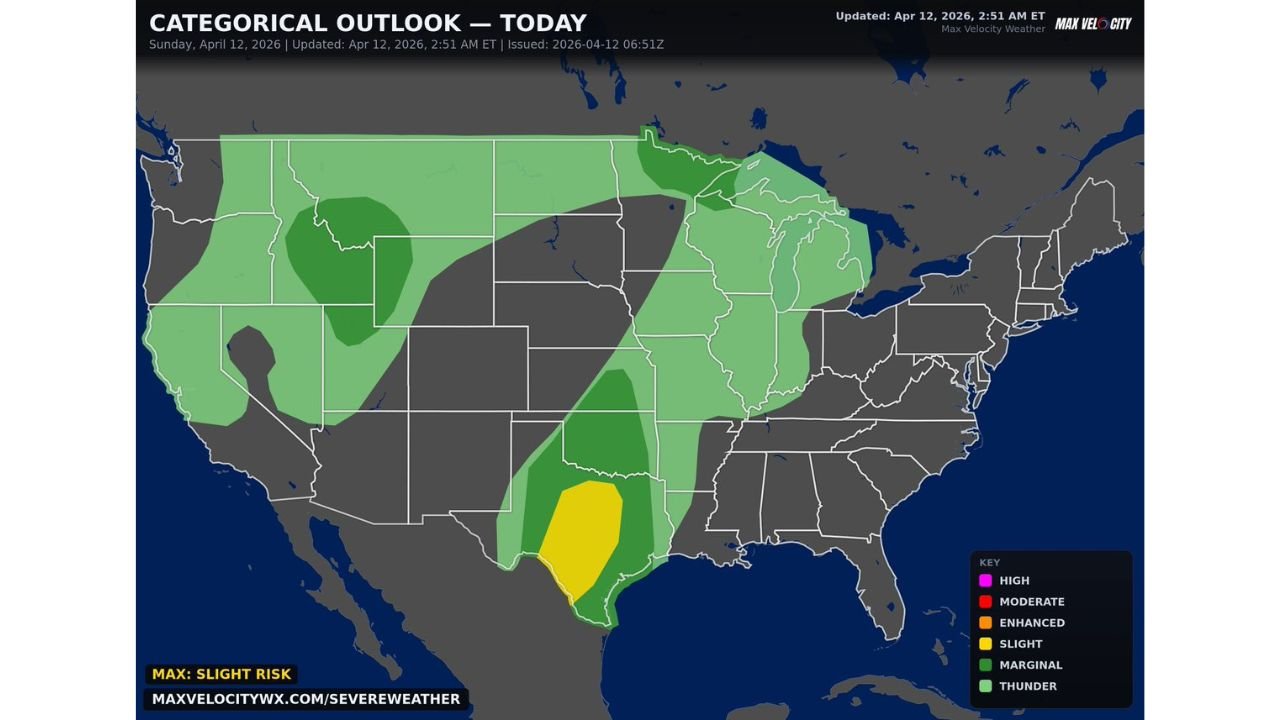
The categorical outlook for Sunday April 12, 2026, updated at 2:51 AM ET and issued at 06:51Z, places the highest risk at a Slight Risk — Level 2 of 5 across a defined zone covering central and southern Texas through Oklahoma and into Kansas. The broader surrounding area carries a Marginal Risk and an even wider General Thunder zone.
The word conditional is doing a lot of work in today’s forecast. The setup is not a guaranteed severe weather producer — atmospheric dynamics make storm initiation uncertain. But the critical detail is this: the atmosphere has enough energy loaded into it that any storm which does manage to fire and sustain itself would quickly become dangerous. The floor today is a quiet afternoon. The ceiling is a major severe weather event. That gap between floor and ceiling is what makes today a day to watch closely.
Risk Zones for Sunday April 12
| Risk Level | Area Covered |
|---|---|
| Slight Risk — Level 2/5 | Central and southern Texas through central Oklahoma — the primary threat zone |
| Marginal Risk — Level 1/5 | Broader Texas, Oklahoma, Kansas corridor extending into surrounding states |
| General Thunder | Wide surrounding area including parts of the Plains, Midwest, and Great Lakes region |
The Slight Risk zone sits over the heart of the threat — a defined oval covering central and southern Texas extending north into central Oklahoma. The Marginal Risk fans out around it, covering a wider swath of the southern Plains and extending into Kansas. A broad General Thunder zone reaches across much of the central United States from the Plains through the Midwest and into the upper Great Lakes.
If a Storm Fires — The Hazards Are Serious
This is the part of today’s forecast that demands the most attention. The setup is conditional, but the potential hazards from any storm that does develop are not minor.
Forecasters identify two specific threats for any supercell that manages to fire today:
- Very large hail — the atmospheric environment supports extremely large hail production if a storm can get rotating and sustaining
- A tornado — tornado development is possible from any organized supercell that fires in the Slight Risk zone today
These are not marginal or borderline hazards. Very large hail and a tornado from a supercell represent the kind of severe weather that causes significant damage and poses a direct threat to life. The highly conditional nature of the setup means most people may see nothing today — but for anyone who finds themselves under a storm that does fire, the situation could escalate rapidly.
Kansas, Oklahoma, and Texas — Stay Alert This Afternoon
Forecasters are specifically calling out Kansas, Oklahoma, and Texas as the states where residents need to remain weather-aware this afternoon. The Slight Risk zone sits over the Texas and Oklahoma portion of that corridor, with the Marginal Risk extending north into Kansas.
The afternoon hours are the critical window. If storm initiation is going to happen today, the afternoon is when conditions will be most favorable for any supercell development along the dryline and associated boundaries in the region. The threat does not extend into the evening in the same way that multi-day setups do — today’s window is focused on the afternoon hours across the southern Plains.
What to Do Right Now If You Are in Kansas, Oklahoma, or Texas
Given the highly conditional but potentially major nature of today’s setup, preparation today requires a specific mindset — staying alert without assuming the threat will definitely materialize.
- Keep a close eye on weather alerts throughout the afternoon — conditions can change quickly if storm initiation begins
- Have your weather app notifications turned on for your specific county so you receive any warnings the moment they are issued
- Know where your shelter is before you need it — do not wait for a tornado warning to start figuring out your safe room
- If you see a storm developing nearby, do not wait for a warning — take shelter immediately and let the warning system catch up
- Avoid outdoor activities in open areas this afternoon across the Slight and Marginal Risk zones until the threat window passes
Today’s Severe Weather Outlook at a Glance
| Factor | Details |
|---|---|
| Valid date | Sunday April 12, 2026 |
| Updated | April 12, 2026 at 2:51 AM ET |
| Maximum risk level | Slight — Level 2 of 5 |
| Primary threat states | Kansas, Oklahoma, Texas |
| Core Slight Risk zone | Central and southern Texas through central Oklahoma |
| Storm initiation | Highly conditional — uncertain |
| Hazards if storms fire | Very large hail, tornado possible |
| Threat timing | This afternoon |
| Severity if storms develop | Could be a major problem |
The Bottom Line — A Quiet Day or a Major Problem
Today has two possible outcomes and very little in between. If storms cannot get organized, today is a non-event across Kansas, Oklahoma, and Texas. If a supercell fires and sustains itself, forecasters are clear — it could be a major problem, with very large hail and a tornado both on the table from a storm that the atmosphere is more than capable of supporting.
That uncertainty is not a reason to ignore today. It is a reason to stay informed, stay alert, and stay ready throughout the afternoon hours across the southern Plains. The conditional nature of the setup means nothing until a storm decides to prove the forecast right — and when that happens, it can happen fast.
Stay with CabarrusWeekly.com for live Sunday severe weather updates, storm initiation alerts, and any watches or warnings issued across Kansas, Oklahoma, and Texas this afternoon.