Historic 1968 Atlantic “Bomb” Storm Revisited: How a Powerful Offshore Cyclone with an Eye Mirrors Modern East Coast Systems
UNITED STATES — Long before social media and round-the-clock weather coverage, a powerful non-tropical cyclone in 1968 rapidly intensified off the East Coast — strong enough to display a clear eye-like feature on early satellite imagery. While many residents don’t remember it, largely because it stayed 100–150 miles offshore, archived surface maps show a classic case of “bombogenesis.”
What Is Bombogenesis?
Bombogenesis occurs when a mid-latitude cyclone rapidly intensifies, typically defined as a pressure drop of at least 24 millibars in 24 hours.
It is not a new phenomenon. Historical weather charts show that strong coastal cyclones have repeatedly formed along the Eastern Seaboard for decades.
The 1968 Offshore Cyclone
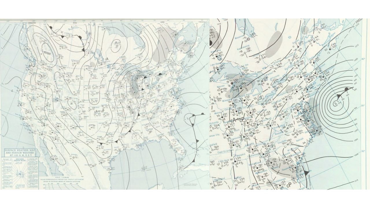
Archived surface weather maps from 1968 show:
• A tightly wound low-pressure system off the Mid-Atlantic coast
• Closely packed isobars indicating strong winds
• A well-defined circulation center offshore
Unlike some recent blizzards that directly impacted major metropolitan areas, this storm remained far enough offshore that widespread inland impacts were limited.
Because of that track, it faded from public memory despite its strength.
Satellite Imagery Captured an “Eye”
One notable feature of the 1968 system was the appearance of an eye-like structure on early satellite imagery. While not tropical in nature, strong mid-latitude cyclones can develop:
• Symmetrical cloud wrapping
• A defined dry slot
• An eye-like center under intense pressure gradients
This can make powerful winter cyclones resemble hurricanes in structure, though they are fueled by entirely different atmospheric processes.
Comparison to Modern Coastal Storms
Recent East Coast winter storms have shown similar characteristics:
• Deepening low pressure offshore
• Strong frontal boundaries along the coast
• Heavy precipitation wrapping around the circulation
The primary difference often comes down to track. A storm 50 miles closer to shore can bring:
• Heavy snow inland
• Blizzard conditions
• Significant wind damage
A storm 100–150 miles offshore may produce impressive satellite imagery but far fewer ground-level impacts.
Why Some Storms Are Remembered — and Others Aren’t
Weather history is often shaped by impact rather than intensity.
A powerful cyclone that stays offshore:
• Produces dramatic ocean conditions
• Displays textbook meteorological structure
• May generate high winds over water
But if it misses population centers, it becomes a footnote in archived charts rather than a headline in memory.
What This Means for Cabarrus County
For North Carolina and Cabarrus County, coastal storm track remains everything.
When strong Atlantic systems:
• Stay offshore — impacts are limited
• Track inland — wind, rain, or snow risks increase
Historical examples like the 1968 bomb cyclone serve as a reminder that explosive coastal development is not a modern occurrence. These systems have been part of East Coast climatology for decades.
We will continue monitoring current and future coastal developments and provide clear context when similar patterns emerge.
For ongoing weather analysis and regional updates, stay with CabarrusWeekly.com.