Historic Freeze Grips the Northeast as 9-Day Subfreezing Streak Hits Philly, DC, and NYC — With Even Colder Air Aimed at the Carolinas This Weekend
NORTH CAROLINA — A stubborn cold spell across the Eastern U.S. is now landing in the history books for several major cities, with a long run of daily high temperatures staying below 32°F—and forecasters warn the coldest air of the season may still be waiting in the wings as we head toward the weekend, including a push that could drag sharper cold into the Carolinas.
A 9-Day Stretch Below Freezing Just Ended in Several Major Cities
The data shared in the update shows multiple Northeast and Mid-Atlantic locations just wrapped up a 9-day streak where the daytime high never reached freezing (32°F), ending on February 1, 2026.
Here’s what the tables show:
- New York City (LaGuardia Airport, NY): 9 consecutive days with highs below 32°F, ending 2026-02-01 (listed as the 8th-longest run on the table shown)
- Philadelphia International Airport, PA: 9 consecutive days with highs below 32°F, ending 2026-02-01 (listed as the 3rd-longest run on the table shown)
- Baltimore-Washington International Airport, MD: 9 consecutive days with highs below 32°F, ending 2026-02-01 (listed as the 3rd-longest run on the table shown)
Those streaks matter because they aren’t just cold nights—this is a pattern where the daytime never truly thaws, which increases risks for frozen pipes, icy sidewalks that don’t melt, and prolonged strain on heating systems.
Why This Cold Spell Is Being Compared to 2018, 1989, and 1979
The post adds historical context that puts this stretch in rare territory for modern winters:
- Boston and NYC: longest streak below 32°F since 2018
- Washington, DC and Baltimore: longest streak below 32°F since 1989
- Philadelphia: longest streak below 32°F since 1979
That doesn’t mean every location broke an all-time record—rather, it shows how unusual it is to stack this many subfreezing highs in a row without a brief warmup to reset the pattern.
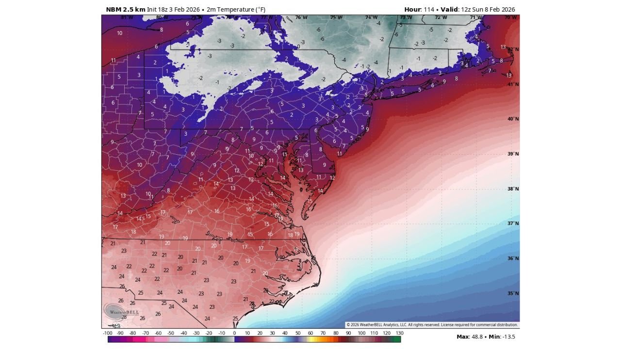
The Next Shot Could Be the Coldest Air of the Season This Weekend
Just as the region starts to climb out of the recent freeze, the update warns that the coldest air of the season may arrive this weekend.
A temperature projection for early Sunday (valid 12z Sunday, Feb. 8, 2026) paints a classic setup: the coldest core holds to the north, but a broad shield of chilly air spreads down the East Coast.
On that map, the Mid-Atlantic sits largely in the single digits and teens, while the Southeast trends colder than normal as well—especially inland areas that can radiate heat away quickly at night.
What This Could Mean for North Carolina and Cabarrus County
Even though the “record streak” stats are tied to places like NYC, Philadelphia, DC, and Baltimore, the same air mass often funnels south behind the main cold core. The temperature map shows much of North Carolina in the 20s during the coldest part of the push, which is a noticeable step down for a typical winter morning in the Piedmont.
For Cabarrus County, the most important takeaway is not snow totals or flashy storm headlines—it’s the quiet impacts:
- Hard freeze potential for sensitive plants and exposed plumbing
- Higher risk of icy patches early in the morning on bridges and untreated roads if any moisture is around
- Increased demand on heaters, especially during the pre-dawn hours when temperatures bottom out
If winds pick up at the same time, it can feel colder than the thermometer suggests, and that’s when cold-related safety problems rise quickly.
Why Long Cold Streaks Create Bigger Day-to-Day Problems
A single very cold morning can be disruptive, but long cold streaks are different. When highs stay below freezing for days at a time, cities see:
- Compounding ice issues as melt-and-refreeze cycles happen on sidewalks and shaded roads
- Frozen pipe risks increase because buildings never get a daytime “reset”
- Vehicle issues like weak batteries and thickened fluids become more common
- Higher heating costs as furnaces run longer and more frequently
Even in North Carolina—where the streaks aren’t usually as extreme—one strong surge can still cause problems if homes and infrastructure aren’t prepared for extended cold.
What To Do Ahead of the Coldest Morning
If this weekend surge verifies the way it’s currently depicted, a few small steps can prevent bigger headaches:
- Drip vulnerable faucets overnight if you’ve had freezing pipe issues before
- Open cabinet doors under sinks on exterior walls to let warmer air circulate
- Bring pets inside and check outdoor water bowls often
- Check space heaters safely (clearance, stable surface, and never running unattended)
- Protect plants that are sensitive to hard freezes with covers or by bringing them indoors
CabarrusWeekly.com will keep tracking how far south the coldest core presses and whether North Carolina ends up on the sharper edge of the weekend chill. If you’re noticing frozen pipes, slick early-morning roads, or big temperature drops where you live, share what you’re seeing—local updates help other Cabarrus County families plan smarter.