Illinois and Great Lakes Region Could See 30–40 Degree Temperature Surge Next Week as European Model Signals Major Midwest Warmup
ILLINOIS — A dramatic pattern shift could send temperatures soaring across the Midwest and Great Lakes next week, with parts of Illinois potentially running 30 to 40 degrees above seasonal averages if current European model projections verify.
The developing setup suggests one of the most significant warm anomalies of the season.
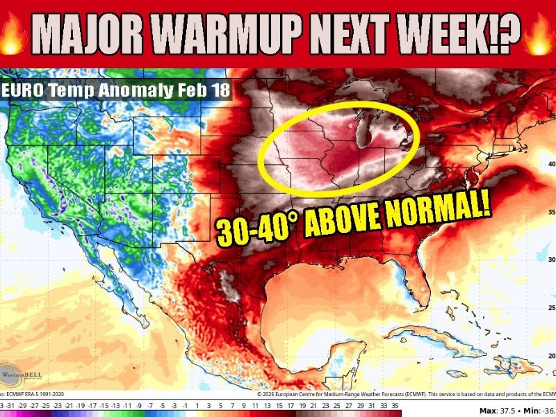
European Model Shows Widespread Midwest Temperature Anomalies
Latest European (EURO) guidance highlights a broad swath of intense warmth stretching from the central Plains through Illinois, Wisconsin, Michigan, Indiana, and into the broader Great Lakes region.
The most striking anomalies appear centered over Illinois, southern Wisconsin, northern Indiana, and Lower Michigan, where projected temperatures may surge 30–40 degrees above normal for mid-February standards. Such departures would represent an unusually sharp break from winter conditions.
What 30–40 Degrees Above Normal Really Means
For mid-February, average highs across much of Illinois typically range from the upper 20s to mid-30s. A 30–40 degree positive anomaly could push afternoon temperatures into the 60s or even near 70 degrees in some locations, depending on cloud cover and wind direction. This level of warmth would feel more like late March or early April rather than the heart of winter.
Why Confidence Is Still Evolving
While the European model strongly supports the warm surge, longer-range forecasts remain subject to change. Model consistency over the coming days will determine whether this amplified ridge pattern locks into place or shifts.
The warmth appears tied to a large upper-level ridge expanding across the eastern half of the United States, allowing milder air to flow northward from the Gulf region into the Midwest and Great Lakes. Should the ridge hold, Illinois and surrounding states could experience multiple consecutive days of unseasonably mild temperatures.
Broader Regional Impacts Across the Great Lakes
Beyond Illinois, elevated temperature anomalies are projected across:
• Wisconsin and Michigan
• Indiana and Ohio
• Portions of the central and southern Plains
The warm signal appears expansive, with the strongest core centered near the western Great Lakes. Such rapid warming can accelerate snowmelt in northern areas and produce sharp day-to-night temperature swings.
Bottom Line
If the European model verifies, next week could bring a significant and potentially record-challenging warm spell across Illinois and the broader Great Lakes region, with temperatures running 30 to 40 degrees above normal.
While forecast details will continue to refine, the signal for a major warmup is strong enough to warrant close monitoring over the coming days. If you notice temperatures rising dramatically in your area next week, share your local readings and conditions with us at CabarrusWeekly.com.