Illinois and Indiana to Ohio and Northern Kentucky Face Conditional Severe Weather Threat Thursday as Dryline and Warm Front Interact
ILLINOIS — A conditional but closely watched severe weather setup is unfolding for Thursday across portions of the Midwest and Ohio Valley, with Illinois, Indiana, Ohio, and Northern Kentucky in the zone for possible semi-discrete supercells capable of producing large hail and a few tornadoes.
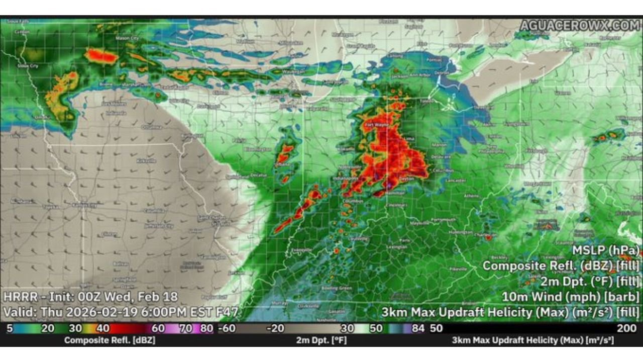
Dryline Setup Focused on Illinois and Indiana
Latest high-resolution model guidance shows the primary initiation zone developing near a dryline positioned across Illinois into Indiana. Forecast soundings suggest limited moisture overall, with warm air aloft acting as a cap in some areas, which could restrict widespread storm coverage.
However, if storms are able to break through the cap, semi-discrete supercells are possible, particularly across central and eastern Illinois into western Indiana. In this corridor, storms would have access to stronger wind shear, supporting an all-hazard threat including damaging winds, large hail, and isolated tornadoes.
Warm Front Extends from Indiana into Ohio and Northern Kentucky
Farther east, a warm front is expected to set up from Indiana into Ohio and Northern Kentucky. Locations along and just south of this boundary could see enhanced low-level wind shear, increasing the tornado potential if storms form in that zone.
Cities including Indianapolis, Cincinnati, Dayton, Louisville, and Columbus fall within the broader area to monitor. While overall moisture remains somewhat limited, dew points climbing into the 50s may be sufficient for rotating storms if instability can develop.
Storms that form along the warm front would likely carry a large hail risk with some tornado potential, especially during the afternoon and early evening hours.
Model Differences Add to Forecast Uncertainty
Forecast confidence is tempered by notable differences among high-resolution models. Some solutions depict more organized convection along the dryline sweeping from Illinois into Indiana and Ohio, while others suggest more scattered development.
The HRRR model in particular trends drier along the warm front with less widespread convection compared to other CAM guidance. That would reduce overall storm coverage, but isolated stronger storms would still remain possible in favorable pockets.
Because of these model discrepancies, Thursday’s threat is considered conditional and highly dependent on moisture quality and boundary placement.
Limited Moisture Keeps Widespread Outbreak Unlikely
Overall moisture appears marginal for a widespread outbreak scenario. The combination of limited low-level moisture and warm air aloft may prevent storms from becoming numerous.
Still, in February setups like this, even modest instability combined with strong wind fields can produce isolated but impactful severe storms. The highest concern remains across Illinois into Indiana, then shifting east into Ohio and Northern Kentucky during the late afternoon and evening.
Residents across the region should monitor forecast updates closely as small changes in moisture and timing could significantly influence storm intensity.
If you are located in Illinois, Indiana, Ohio, or Kentucky and experience severe weather Thursday, share your conditions and reports with CabarrusWeekly.com as we continue tracking this evolving situation.