Illinois and Northwest Indiana Brace for Tornadoes Along Warm Front Tuesday Evening as Chicago, Joliet and Peoria Split Between Twister and Giant Hail Threat
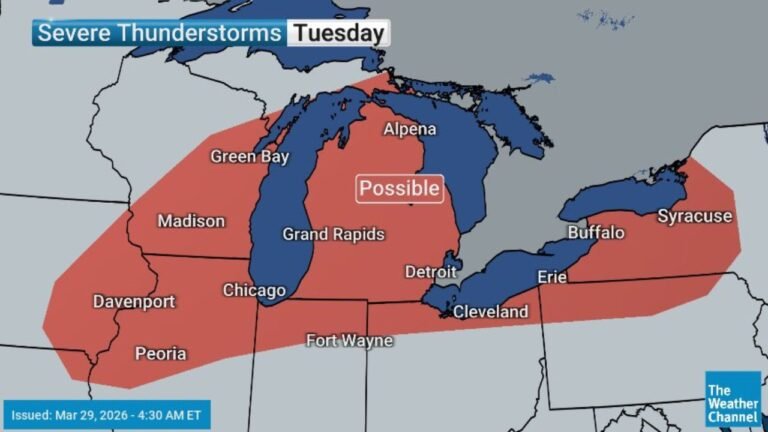
NORTHWEST INDIANA — A dangerous severe weather setup is expected to unfold Tuesday afternoon and evening across Illinois and northwest Indiana, with the warm front acting as a sharp dividing line between different — but equally serious — threats.
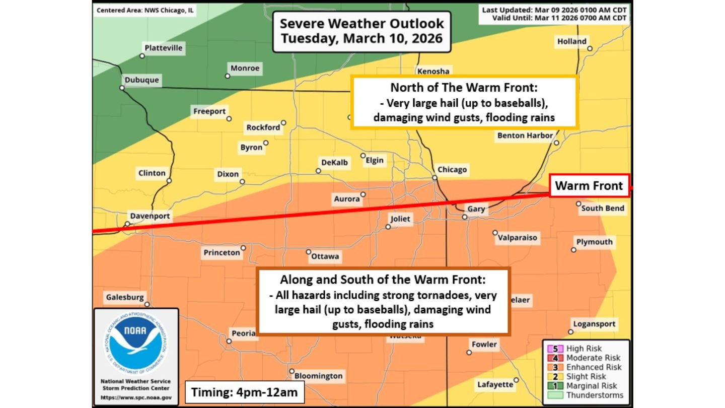
Forecasters indicate that areas along and south of the warm front will be the primary focus for tornado development, while locations north of the boundary will face a heightened risk of very large hail, damaging winds, and flooding rains.
Storms are expected to develop between 3 and 5 p.m. and gradually wind down around midnight.
Tornado Focus Along and South of the Warm Front
The warm front is forecast to stretch roughly from near Davenport eastward through the Chicago metro and into northwest Indiana near Gary and South Bend.
Communities south of that line — including:
- Joliet
- Ottawa
- Princeton
- Peoria
- Bloomington
- Areas south and southwest of Chicago
— are positioned in an environment supportive of all severe hazards, including the possibility of strong tornadoes.
Meteorologists note that the most favorable tornado corridor will likely sit just south of the warm front, where low-level wind shear and instability are maximized.
If storms remain discrete supercells before clustering into lines, a few tornadoes — potentially strong — could develop in this zone.
North of the Front: Giant Hail and Damaging Winds
For areas north of the warm front, including:
- Rockford
- DeKalb
- Elgin
- Chicago
- Kenosha
- Benton Harbor
The primary hazards shift toward:
- Very large hail (possibly up to baseball size)
- Damaging wind gusts
- Flooding rains
While tornado risk may be lower north of the boundary, the hail and wind threat could still produce significant impacts, especially during the late afternoon and early evening.
Flash Flooding a Concern Statewide
All areas across northern and central Illinois are expected to face a flash flood threat due to the intensity of the storms.
With strong updrafts capable of producing torrential rainfall rates, localized flooding could develop quickly in urban corridors — especially around Chicago and surrounding suburbs.
Repeated storms moving along the boundary could enhance rainfall totals in some communities.
Timing: Late Afternoon Through Midnight
The window for severe weather is expected to begin between 3–5 p.m. Tuesday, intensify through the evening commute hours, and taper off near midnight.
This timing raises concerns for:
- Evening travel disruptions
- Reduced visibility during tornado warnings
- Storms impacting heavily populated metro areas
Residents across Illinois and northwest Indiana should closely monitor forecast updates throughout the day Tuesday.
A Sharp Boundary, Two Distinct Threats
This setup highlights how small shifts in the warm front position could dramatically change local impacts.
A northward shift would expand the tornado risk zone.
A southward shift could increase hail and wind threats in areas currently forecast for tornado potential.
Because of this, the exact placement of the boundary Tuesday afternoon will be critical.
Bottom Line
Illinois and northwest Indiana face a significant severe weather threat Tuesday afternoon through late evening. Along and south of the warm front — including Joliet, Peoria, and areas south of Chicago — tornadoes, very large hail, damaging winds, and flooding rains are possible. North of the boundary, giant hail, damaging winds, and heavy rainfall remain the primary concern.
CabarrusWeekly.com will continue to monitor forecast updates as the warm front position and storm timing become clearer ahead of Tuesday’s event.