Illinois and Wisconsin Snowfall Update: Northern Illinois Sees Minor Dusting While Southern Wisconsin and Upper Midwest Brace for 2 to 5 Inches
ILLINOIS — Light snow is expected to move across northern portions of the state today, but meaningful accumulation will stay mostly north of the Illinois border, with heavier snowfall targeting Wisconsin and other parts of the Upper Midwest.
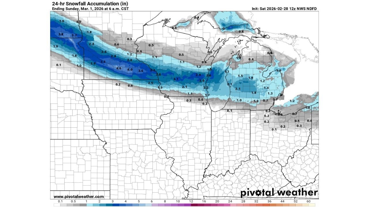
The latest 24-hour snowfall outlook shows Illinois sitting along the southern edge of the primary snow band, limiting totals compared to areas farther north.
Northern Illinois: Light Snow with Limited Accumulation
Across northern Illinois, including areas near Rockford and counties bordering Wisconsin, snowfall totals are projected to remain modest.
Most locations are expected to see little to no accumulation, with a dusting up to around 1 inch possible near the Wisconsin state line. Areas farther south toward central Illinois are forecast to receive only light flurries or brief snow showers with minimal impact.
Daytime temperatures near freezing may further limit sticking on roads, though untreated surfaces could briefly become slick during periods of steadier snowfall.
Wisconsin Positioned for Heavier Snow
The core of this system is aligned directly over southern and central Wisconsin, where snowfall totals increase significantly.
Forecast projections show:
- Southern Wisconsin: Approximately 2 to 4 inches
- Central Wisconsin: Localized areas potentially reaching 4 to 5 inches
- Northern Wisconsin: Generally lighter totals compared to central sections but still higher than Illinois
This northward shift of the heavier band keeps Wisconsin squarely in the zone of stronger lift and deeper moisture.
Minnesota, South Dakota, and Northern Iowa Also Impacted
The snowfall corridor extends westward beyond Wisconsin into portions of the northern Plains and Upper Midwest.
Areas across:
- Southern Minnesota
- Eastern South Dakota
- Northern Iowa
are projected to receive 3 to 5 inches, with isolated pockets exceeding that where banding strengthens.
These states sit within the most concentrated part of the snow shield, where atmospheric forcing supports steadier precipitation rates.
Michigan’s Snowfall Outlook
Parts of northern Michigan are also forecast to receive 1 to 3 inches as the system tracks eastward. Snowfall intensity appears somewhat lighter than Wisconsin but still more substantial than Illinois totals.
Why Illinois Is on the Edge of the System
Illinois remains positioned along the southern fringe of the storm’s primary deformation band — the region that typically produces the heaviest snowfall rates.
Because the strongest dynamics remain north:
- Illinois snowfall rates stay lighter
- Duration of steady snow remains shorter
- Accumulation potential decreases sharply southward
This placement explains the clear gradient between light Illinois totals and heavier Wisconsin amounts.
What Residents Should Expect Today
For Illinois residents, particularly in northern counties:
- Expect light snow during the morning and afternoon hours
- Anticipate minimal accumulation for most locations
- Prepare for localized slick spots near the Wisconsin border
For Wisconsin, Minnesota, South Dakota, Iowa, and parts of Michigan, plowable snowfall is more likely, especially where totals exceed 3 inches.
As this winter system progresses eastward, snowfall intensity will gradually shift toward the Great Lakes region.
If you are experiencing snowfall in your area today, share your conditions and totals with CabarrusWeekly.com so we can continue tracking this Upper Midwest winter system in real time.