Illinois Faces Late-Week Weather Showdown: Cold Rain and Thunder Possible While Wisconsin and Minnesota Eye Snow Risk
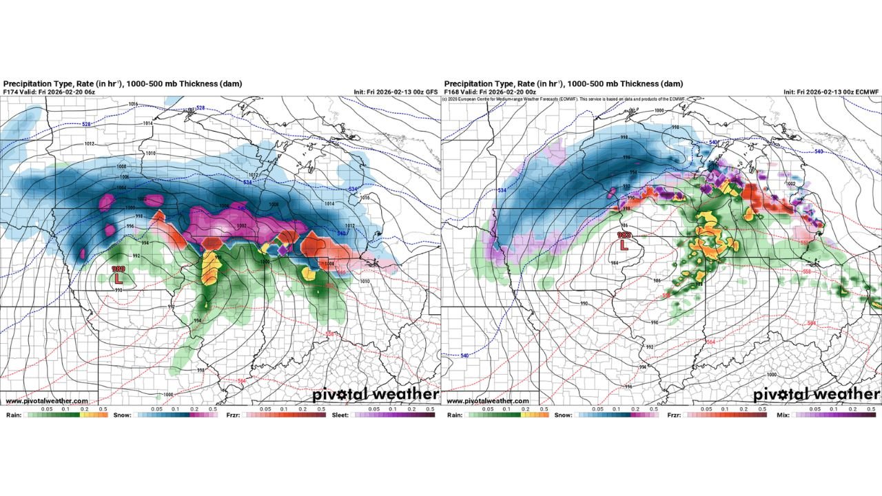
ILLINOIS — A developing storm system slated for Thursday evening into Friday morning is creating forecast uncertainty across the Midwest, with Illinois positioned between a cold rain and thunderstorm scenario and a rain-to-snow setup farther north.
Two major forecast models are showing different outcomes, keeping confidence moderate at best this far out.
Competing Model Scenarios for Thursday Night
The European model depicts a setup favoring showers and thunderstorms across Illinois, driven by a surge of warmer, unstable air lifting northward into the state. Under this solution, precipitation would remain primarily rain, with embedded thunder possible, especially in central and southern Illinois.
Meanwhile, the GFS model trends colder. It shows a broader swath of mixed precipitation and snow extending across Wisconsin and Minnesota, with Illinois closer to a colder rain zone but near the edge of the transition line.
This difference hinges on how far north the warmer air can push before colder air wraps in from the northwest.
Illinois Likely in the Cold Rain Zone
Current trends lean toward a cold rain event for much of Illinois, particularly from Chicago south through Springfield and into southern counties.
Rainfall appears likely Thursday night into early Friday, with temperatures hovering near but generally above freezing. If the warmer solution verifies, isolated thunderstorms could develop if enough instability reaches this far north.
However, if the colder GFS scenario gains support, northern Illinois could flirt with a rain-to-snow mix late in the event, though widespread accumulation appears more likely farther north.
Snow Threat Focused Across Wisconsin and Minnesota
Both model solutions suggest that Wisconsin and Minnesota hold the higher probability for snow, especially on the northern and western sides of the developing low-pressure system.
Heavy snow bands could set up in those areas where colder air is firmly entrenched. The exact placement of that transition zone remains uncertain and will depend on storm track and thermal profiles.
Even a Strong Storm Risk in Play for Illinois
If sufficient warm, unstable air surges northward ahead of the system, parts of Illinois could experience a few stronger thunderstorms. While widespread severe weather is not currently indicated, a narrow corridor of enhanced convection cannot be ruled out.
That scenario would require deeper moisture return and stronger instability than currently forecast, but it remains a conditional possibility.
Still Early — Both Outcomes Possible
With several days remaining before the event, model adjustments are likely. Small changes in storm track or temperature profiles could shift the rain-snow line by 50 to 100 miles, significantly altering impacts for northern Illinois.
For now, the most probable outcome appears to be cold rain across Illinois with snow mainly confined to Wisconsin and Minnesota, but confidence will increase as newer model runs refine the system’s track.
If you’re in Illinois and tracking this late-week system, share your expectations and local observations with us at CabarrusWeekly.com.