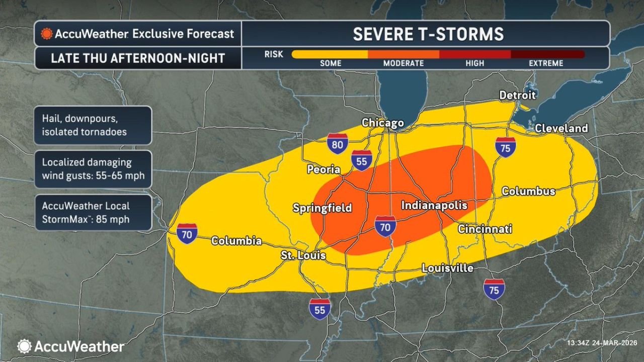
Illinois, Indiana and Ohio Including Chicago, Indianapolis and Columbus Face Severe Thunderstorms With Damaging Winds and Flood Risk Thursday
OHIO VALLEY — A significant severe weather setup is expected Thursday afternoon into the night, with storms targeting Illinois, Indiana, and Ohio, bringing damaging winds, hail, and heavy rainfall that could lead to localized flooding.
Storm Threat Expands Across Illinois, Indiana and Ohio
The highest risk zone stretches from central Illinois through Indiana into Ohio, including major cities like Chicago, Indianapolis, and Columbus.
This region is expected to see strong to severe thunderstorms developing late Thursday afternoon and continuing into the night. The setup indicates a well-organized system capable of producing widespread impacts across multiple states.
Areas in the surrounding zone, including parts of Missouri, Kentucky, and western Ohio, may also experience strong storms, though the most intense activity is expected within the core region.
Damaging Winds and Hail Main Concerns
The primary threat with these storms will be damaging wind gusts reaching 55 to 65 mph, which could lead to downed trees, power outages, and travel disruptions.
In addition, storms may produce hail and intense downpours, with some cells potentially becoming strong enough to generate isolated tornadoes.
Localized reports could see even stronger wind gusts in isolated areas, increasing the risk of structural damage and hazardous conditions during peak storm activity.
Heavy Rain Could Trigger Flooding Issues
Alongside severe storms, heavy rainfall is expected to become a major concern, especially as storms move repeatedly over the same areas.
This could lead to localized flooding in low-lying and urban locations, particularly in cities like Indianapolis and Columbus, where runoff can quickly accumulate.
The combination of intense rain and already saturated ground in some areas may increase the likelihood of flash flooding during the evening and overnight hours.
Timing Points to Late Afternoon Through Night
Storm development is expected to begin late Thursday afternoon, intensifying as the system tracks eastward through the evening.
The most active period will likely occur during the evening into nighttime hours, when storms reach peak strength across Indiana and Ohio.
Residents should be prepared for rapidly changing conditions, especially during the evening commute and overnight period when visibility and travel conditions may worsen.
A High-Impact Weather Day for the Ohio Valley
This setup reflects a classic spring severe weather pattern, where warm, unstable air interacts with a strong weather system moving through the region.
With multiple hazards expected—including damaging winds, hail, isolated tornadoes, and flooding rainfall—this could become a high-impact weather event across the Ohio Valley.
Residents across Illinois, Indiana, and Ohio are urged to stay alert, monitor warnings, and be prepared to take action if severe weather develops in their area.
Residents are encouraged to report conditions in their area and stay updated with the latest weather alerts on CabarrusWeekly.com.