Illinois, Indiana, Kentucky and Missouri Brace for Two-Round Severe Weather Threat Thursday as Warm Front Lifts North
ILLINOIS — A strong storm system is expected to move into the Midwest Thursday, bringing a two-round severe weather setup across portions of Illinois, Indiana, Kentucky, and Missouri, with forecasters highlighting a wind, hail, and brief tornado risk during the day.
First Round Develops Thursday Morning Along Lifting Warm Front
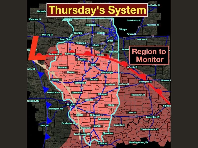
The first wave of storms is expected between 8 AM and 2 PM as a warm front lifts north across the region. Areas highlighted for monitoring include Peoria, Springfield, Decatur, Champaign, Galesburg, Quincy, Bloomington, and Effingham in Illinois, along with surrounding portions of western Indiana and eastern Missouri.
During this morning round, storms may produce strong wind gusts, hail, and a brief tornado risk, particularly near and just south of the advancing warm front. While widespread severe weather is not anticipated at this time, isolated stronger cells could quickly intensify. The threat remains conditional on storm organization, but even early-day systems can generate localized impacts if instability and wind shear align.
Afternoon Round After 3 PM Highly Conditional but Potentially Stronger
A second round of storms is possible after 3 PM, though this phase is described as highly conditional. Development will depend on how the morning storms evolve and whether the atmosphere can recover enough to support renewed severe activity.
If storms redevelop during the afternoon and evening hours, all severe modes would be possible, including damaging winds, hail, and isolated tornadoes. This secondary threat zone extends eastward into Indianapolis, Bloomington, and Lafayette, Indiana, as well as southward toward Louisville and Bowling Green, Kentucky.
Because this round depends on atmospheric recovery following the morning activity, forecasters emphasize that not every location will see severe weather. However, the setup warrants close monitoring as conditions can escalate within a short window.
Region to Monitor Includes Central and Southern Illinois into Indiana and Kentucky
The primary region of concern stretches across much of central and southern Illinois, including areas along and south of Interstate 74 and Interstate 70 corridors. Communities such as Carbondale, Marion, Mt. Vernon, Olney, and Vandalia also fall within the broader monitoring zone.
Western Kentucky and parts of southern Indiana are included in the extended outlook area, indicating that the storm track may shift eastward later in the day depending on frontal positioning.
While the overall severe threat is categorized as relatively low at this time, winter storm systems in this region can strengthen rapidly within 24 hours. Residents should stay weather-aware throughout Thursday.
Not a High-End Outbreak, But Awareness Is Key
Forecasters describe this as more of a “keep an eye out and be aware” situation, rather than a high-end outbreak scenario. However, the presence of a lifting warm front and sufficient wind dynamics means isolated severe storms cannot be ruled out.
Given the conditional nature of the second round, updated forecasts Thursday morning will be critical in refining timing and impact zones. Residents across Illinois, Indiana, Kentucky, and Missouri should monitor updated forecasts, ensure weather alerts are enabled, and remain prepared for rapid changes in conditions.
If you are experiencing storms in your area Thursday, share your conditions and updates with CabarrusWeekly.com as we continue to monitor this developing weather situation.