Illinois, Indiana, Michigan and Wisconsin Face Explosive Severe Storms Sunday Night Before Rapid Change to Snow by Monday Morning
UNITED STATES — A powerful cold front is set to trigger a dramatic weather whiplash across Illinois, Indiana, Michigan and Wisconsin late Sunday into Monday, bringing severe thunderstorms followed by a rapid transition to accumulating snow — all within roughly 15 hours.
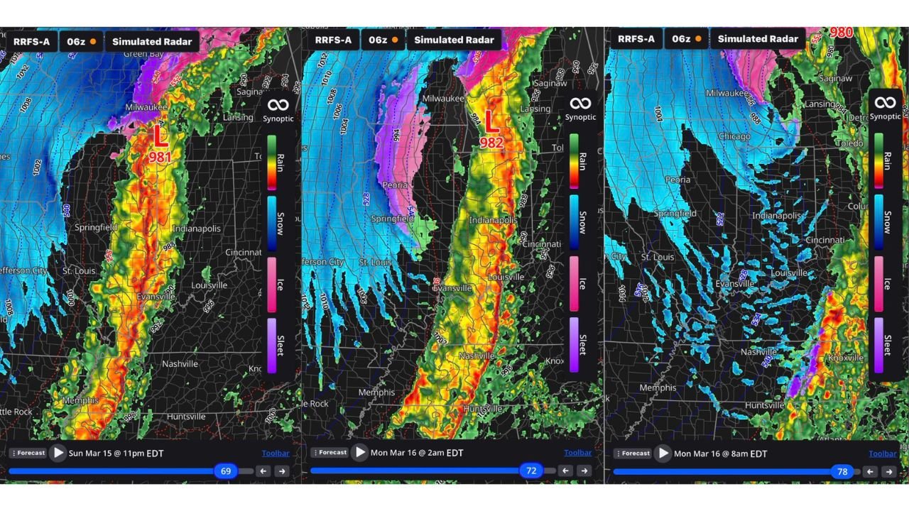
Forecast model simulations show a deepening low pressure system tracking north through the Midwest Sunday night, with a tightly organized line of intense thunderstorms racing north from Tennessee through Indiana and into Michigan.
Sunday 11 PM: Severe Line Intensifies
By late Sunday evening, around 11 p.m., a solid line of heavy thunderstorms is projected from:
- Memphis, Tennessee
- Nashville, Tennessee
- Evansville, Indiana
- Indianapolis, Indiana
- Stretching north toward Milwaukee, Wisconsin
This line could produce widespread severe weather reports, including damaging winds and embedded tornado potential, as temperatures surge into the 70s ahead of the front.
The simulated radar shows a classic high-impact squall line aligned south-to-north, feeding into a strengthening surface low near the western Great Lakes.
Monday 2 AM: Storms Push East, Cold Air Crashes In
By 2 a.m. Monday, the low intensifies further as it tracks into Michigan. The severe line shifts east toward:
- Cincinnati, Ohio
- Louisville, Kentucky
- Detroit, Michigan
Behind the front, colder air begins rushing in rapidly across Illinois and Missouri. Rain transitions to a wintry mix and then snow from:
- St. Louis, Missouri
- Springfield, Illinois
- Peoria, Illinois
- Western Indiana
Temperatures begin a steep drop as the Arctic air surges southeast.
Monday 8 AM: Snow and Temperatures in the Teens
By Monday morning, much of Illinois, Indiana and parts of Michigan are projected to be fully on the cold side of the system.
Snow spreads across:
- Chicago, Illinois
- Indianapolis, Indiana
- Central Illinois
- Western Michigan
What was severe weather just hours earlier transitions to snow showers and gusty winds. Temperatures that were in the 70s Sunday evening could plunge into the 20s — and potentially the teens — by Monday morning in some locations.
A Rare and Violent Temperature Swing
The setup represents one of the more extreme frontal passages of the season, with:
- Hundreds of potential severe weather reports Sunday night
- A powerful 981–982 mb low strengthening over the Great Lakes
- Rapid cold air advection changing rain to snow overnight
- A drop of 40–50 degrees in less than a day
Such swings are uncommon but possible in mid-March when winter and spring air masses collide.
Travel and Impact Concerns
Sunday night travel could be dangerous due to severe storms, especially along the Interstate corridors near:
- I-65 (Indiana)
- I-70 (Illinois/Indiana)
- I-75 (Michigan)
By Monday morning, slick roads and blowing snow could create an entirely different hazard for the morning commute across Illinois and Indiana.
Bottom Line
Illinois, Indiana, Michigan and Wisconsin are in the path of a powerful front Sunday night into Monday that could deliver severe thunderstorms followed quickly by snow and plunging temperatures.
From 70-degree warmth to wintry conditions in under 15 hours, this system has the potential to create widespread impacts across the Midwest.
CabarrusWeekly.com will continue to track forecast updates as timing and snowfall details become clearer.