Illinois, Indiana, Mississippi and Alabama Under Enhanced Severe Risk as Midwest and Deep South Brace for Widespread Damaging Winds and Tornadoes Sunday
UNITED STATES — A significant severe weather outbreak is expected to unfold Sunday across portions of the Midwest and Deep South, with forecasters highlighting a corridor from Illinois and Indiana south through Mississippi and Alabama as the primary zone for damaging winds and possible tornadoes.
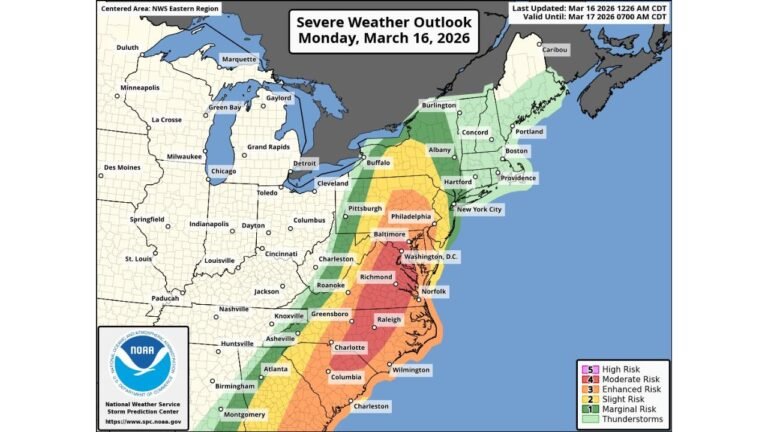
According to the latest severe weather outlook valid Sunday, March 15, 2026, an Enhanced Risk (Level 3 of 5) stretches from parts of Illinois and Indiana southward through western Tennessee, much of Mississippi, and into Alabama. Surrounding this area, a broader Slight Risk (Level 2) extends into Louisiana, Kentucky, Ohio and parts of the Southeast.
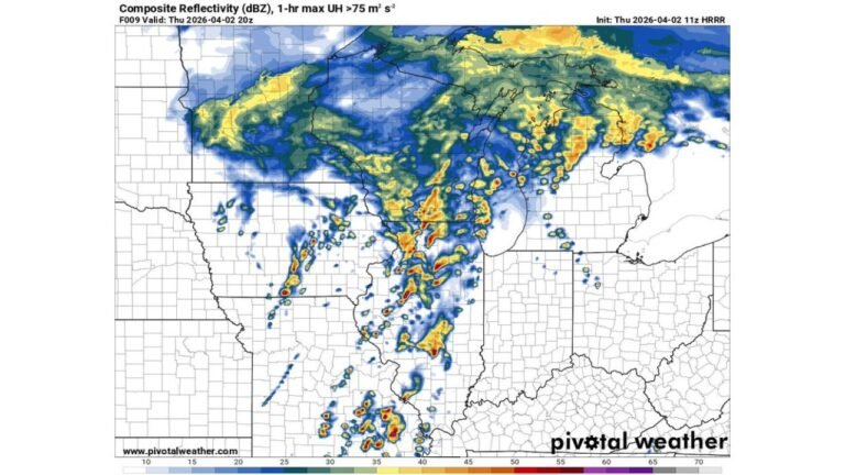
Squall Line Developing Around 4 PM
Meteorologists indicate that a squall line is expected to develop around 4 p.m. Sunday across the lower Mississippi Valley. Once organized, this line of storms will march eastward through the evening and overnight hours.
The primary concern with this setup is widespread damaging straight-line winds, which could impact multiple states along the path of the line.
Communities in:
- Central and southern Illinois
- Much of Indiana
- Western and central Tennessee
- Mississippi
- Alabama
are likely to experience the strongest portion of this system as it intensifies.
Wind Threat Appears Significant
Forecasters emphasize that damaging wind gusts will be the dominant hazard. As the squall line surges east, strong winds could become widespread, especially within the Enhanced Risk zone.
This type of setup — a fast-moving, organized line of storms — is capable of producing extensive wind damage over a large geographic area.
Power outages, downed trees, and structural damage are all possible where the most intense winds occur.
Tornadoes Possible, Including QLCS Tornadoes
In addition to the wind threat, multiple tornadoes are possible along and within the squall line. These would most likely be QLCS (quasi-linear convective system) tornadoes — brief but potentially damaging tornadoes embedded within the line.
While tornadoes may not be the dominant hazard, forecasters caution that the environment could support at least a few tornadoes as the line advances eastward Sunday evening and into the overnight hours.
Residents in Mississippi, Alabama, western Tennessee, Illinois and Indiana should remain alert for rapid warnings, especially after dark.
Risk Extends Into the Southeast
The broader Marginal and Slight Risk areas include parts of:
- Louisiana
- Kentucky
- Ohio
- Georgia
- Florida Panhandle
- The Carolinas
While the highest threat remains farther west, storms could maintain intensity as they push east.
Timing and Preparation Critical
With storms expected to organize during the late afternoon and continue into the evening and overnight, timing is a major concern — particularly for areas that will see severe weather after sunset.
Residents across the risk zone should:
- Ensure Wireless Emergency Alerts are enabled
- Have multiple ways to receive warnings
- Review shelter plans in advance
- Charge phones and backup batteries
This is not expected to be an isolated storm event. Instead, a broad swath of the Midwest and Deep South could see impacts from the same organized line of severe weather.
Bottom Line
Sunday’s setup points toward a potentially widespread severe weather event across Illinois, Indiana, Mississippi, Alabama and surrounding states. A squall line developing around 4 p.m. is expected to move east, bringing damaging winds and the possibility of multiple tornadoes.
If you are within the highlighted risk area, preparation should happen now — before storms begin to develop.
CabarrusWeekly.com will continue tracking updates as this severe weather outbreak approaches.