Illinois, Indiana, Ohio and Kentucky Face Unseasonable February Tornado Risk Thursday as Supercells Track East from the Mississippi River
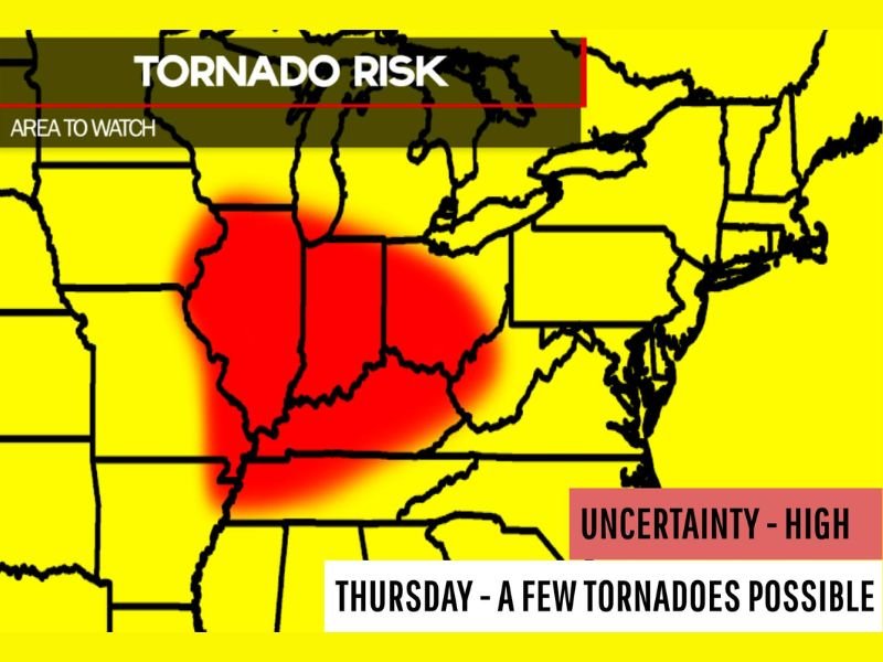
ILLINOIS — An unusual February severe weather setup is taking shape for Thursday, with a few tornadoes possible across parts of the Ohio Valley and Midwest, beginning in Illinois and tracking east toward Indiana, Ohio, and Kentucky.
Warm, Moist Air Surges North Ahead of Strong Surface Low
Temperatures are expected to turn unseasonably warm, with dew points climbing into the upper 50s and lower 60s across portions of the region. That level of moisture is more typical of spring than late winter and will provide fuel for developing thunderstorms.
A strong surface low combined with powerful low-level winds will enhance wind shear across the Mississippi River Valley. This environment could allow supercells to develop during the afternoon, especially across central and southern Illinois.
Tornado Risk Begins in Illinois, Spreads East
The area to watch includes much of Illinois along and east of the Mississippi River, where storms are expected to initiate first. Cities such as Springfield, Peoria, Decatur, and Champaign could fall within the initial development zone.
As storms organize, they are expected to move east into Indiana, Ohio, and Kentucky, including areas near Indianapolis, Cincinnati, Louisville, and Columbus. If atmospheric ingredients fully align, isolated tornadoes could form within discrete supercells or embedded within larger storm clusters.
Forecasters note that while the overall number of tornadoes may remain limited, the environment does support a few potentially stronger storms capable of producing damaging winds, large hail, and tornadoes.
Small-Scale Outbreak Cannot Be Ruled Out
Although widespread severe weather is not guaranteed, the setup carries high uncertainty, meaning small changes in storm timing or instability could significantly influence outcomes. If storms remain discrete and instability increases more than currently expected, a small-scale tornado outbreak cannot be ruled out.
February tornado events are less common but not unprecedented in the Ohio Valley. Strong dynamic systems during late winter can occasionally create early-season severe weather episodes when Gulf moisture surges northward.
High Uncertainty, But Close Monitoring Needed
The risk zone highlighted spans much of the central Midwest into the Ohio Valley, with the highest concern centered on Illinois and adjacent states. Given the volatile mix of warm air, strong wind fields, and advancing low pressure, Thursday’s setup warrants close attention.
Residents across Illinois, Indiana, Ohio, and Kentucky should ensure weather alerts are enabled and review severe weather safety plans ahead of the afternoon and evening hours.
We will continue tracking this developing severe weather threat. Share your local conditions and storm reports with CabarrusWeekly.com as this unusual February setup unfolds.