Illinois, Indiana, Ohio and Western Pennsylvania Face Tornado Threat Today as Supercell Corridor Sets Up Across Midwest
ILLINOIS, INDIANA, OHIO, PENNSYLVANIA — A dangerous severe weather setup is unfolding today across parts of the Midwest and into the Ohio Valley, where a corridor of supercells is expected to develop with the potential to produce tornadoes.
Forecasters are highlighting the possibility of a few significant tornadoes, along with other severe hazards, as storms organize later this afternoon and evening.
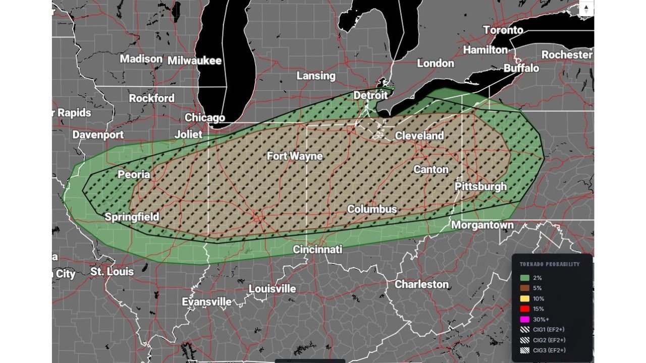
Supercell Corridor Extends Across Multiple States
The primary risk zone stretches from:
- Central and eastern Illinois
- Through Indiana
- Across much of Ohio
- Into western Pennsylvania
Cities within or near this corridor include Peoria, Springfield, Fort Wayne, Indianapolis, Columbus, Cleveland, and Pittsburgh, placing a large portion of the population under heightened alert.
This setup favors discrete supercells along a frontal boundary, which increases the likelihood of rotating storms capable of producing tornadoes.
Tornado Potential Elevated Along Frontal Boundary
The highest tornado threat is expected along and just ahead of the advancing front, where atmospheric conditions will be most favorable for storm rotation.
Key factors supporting tornado development include:
- Strong wind shear allowing storms to rotate
- Warm, unstable air feeding into developing thunderstorms
- Storms remaining isolated enough to maintain structure
This environment raises concern for a couple of stronger tornadoes, rather than just brief or weak spin-ups.
Multiple Severe Hazards Expected Beyond Tornadoes
In addition to tornado risk, storms across the region could produce:
- Very large hail capable of damaging vehicles and property
- Damaging straight-line winds with the potential for widespread outages
- Heavy rainfall that may lead to localized flooding in some areas
These threats may occur simultaneously within the strongest storms, increasing the overall impact.
Timing Favors Late Afternoon Through Evening Impacts
Storms are expected to develop and intensify during the late afternoon hours, with peak severe weather potential continuing into the evening.
- Initial development may begin in Illinois and Indiana during mid to late afternoon
- Storms will then track east into Ohio and western Pennsylvania through the evening hours
This timing places many communities at risk during high-activity evening periods, when people are commuting or returning home.
High-End Severe Weather Setup Demands Attention
The combination of supercell development, tornado potential, and widespread severe hazards makes this a high-impact weather day across the region.
Residents in the affected areas should remain weather-aware, ensure they have a way to receive alerts, and be prepared to act quickly if warnings are issued.
Stay with CabarrusWeekly.com for continued updates as storms develop and move across the Midwest and Ohio Valley.