Illinois, Indiana, Ohio, Michigan Face Severe Storm Risk Tuesday With Damaging Winds, Large Hail and Isolated Tornado Threat
OHIO VALLEY — A developing severe weather setup is expected to impact parts of the Midwest and Great Lakes on Tuesday, bringing scattered strong to severe thunderstorms capable of damaging winds, large hail, and isolated tornadoes.
Storm Development Expected Tuesday Afternoon
Forecast data shows storms beginning to develop during the Tuesday afternoon hours, especially across Illinois, Indiana, and Missouri, before expanding eastward into Ohio and Michigan later in the day.
This timing suggests peak instability will align with daytime heating, increasing the potential for stronger storm structures as the system organizes.
By late afternoon into the evening, storms are expected to become more widespread, particularly along a corridor stretching from Chicago to Detroit and into northern Ohio.
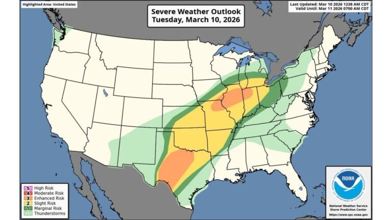
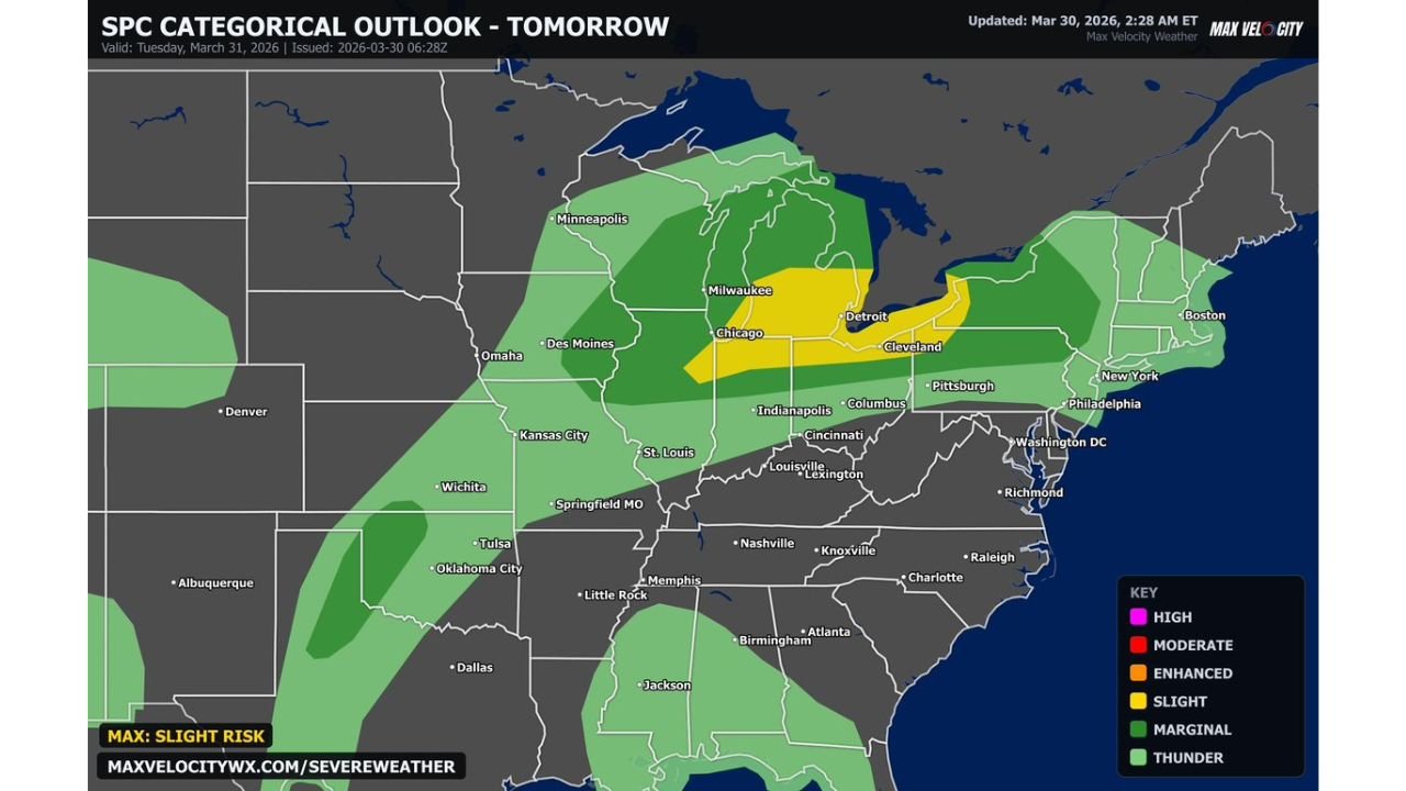
Slight Risk Area Highlights Key Impact Zone
The Storm Prediction Center outlook places a Slight Risk (Level 2 of 5) across a focused zone that includes northern Illinois, northern Indiana, southern Michigan, and northern Ohio.
Cities within this zone include Chicago, Detroit, Cleveland, and surrounding metro areas, where conditions are most favorable for stronger storms.
Surrounding this area, a broader Marginal Risk extends across much of the Midwest and into parts of the Great Lakes, indicating that isolated severe storms are still possible outside the core risk zone.
Primary Threats Include Wind, Hail and Isolated Tornadoes
The main concerns with this system will be damaging wind gusts and large hail, especially with any storms that organize into clusters or lines.
However, the setup also supports a low-end tornado threat, particularly if discrete supercells are able to develop ahead of the main line.
These storms could briefly intensify and produce localized but potentially impactful severe weather, even if the overall tornado risk remains limited.
Storms Track East Into Evening Hours
As the system progresses, storms will push eastward into Ohio, western Pennsylvania, and parts of the lower Great Lakes region during the evening hours.
This could bring strong storms into cities like Cleveland and Pittsburgh after sunset, when visibility is lower and conditions can become more dangerous for travel.
The eastward movement also suggests that multiple states could see impacts within a relatively short time window.
Preparedness Recommended Ahead of Active Weather Day
With multiple severe weather hazards possible, residents across the region should remain alert through Tuesday.
Having a plan in place is important, especially in areas within the Slight Risk zone where storm intensity could increase quickly during the afternoon and evening.
Even outside the highest risk areas, isolated severe storms could still develop, making it important to stay updated on changing conditions throughout the day.
Stay with CabarrusWeekly.com for continued coverage, and share what conditions you are seeing in your area as storms move through the Midwest and Great Lakes.