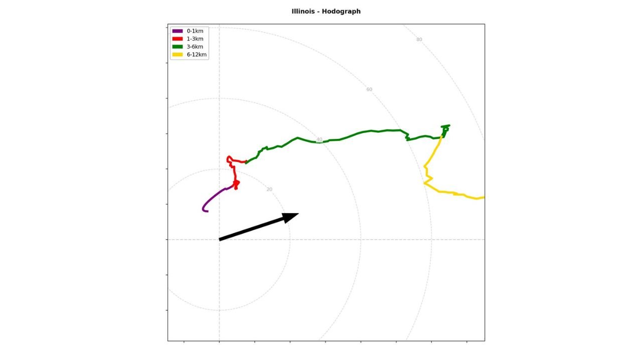
Illinois RISE-26 Sounding Reveals Cleaned-Up Surface Winds and Strong Directional Shear Aloft as Hodograph Highlights Storm Potential
ILLINOIS — A recent RISE-26 weather balloon launch is offering a detailed look at the vertical wind profile over the state, though not without challenges near the surface as forecasters work to clean up noisy launch data and better represent true wind structure.
Surface Data Noise Creates Hodograph Challenge
Meteorologists analyzing the RISE-26 sounding noted that the lowest levels of the hodograph can be contaminated by erratic motion at launch, particularly as the balloon and sonde swing on a roughly 100-foot tether.
Because wind speed and direction are derived from GPS position changes, any bouncing or lateral swinging of the balloon immediately after release can artificially skew the lowest wind vectors. In cases where no reliable surface wind vector is available from a nearby weather station, forecasters must carefully decide how much of that near-ground data to omit.
If not removed, the lowest portion of the hodograph may reflect the swinging string rather than the actual atmospheric wind.
Cleaned Hodograph Shows Organized Wind Structure
After smoothing and removing unreliable surface data, the Illinois hodograph reveals a much clearer picture of the wind field from the surface upward.
The 0–1 km layer shows modest curvature, indicating low-level directional change with height, a key ingredient in organized storm development. From 1–3 km, the hodograph expands outward, signaling increasing wind speeds and strengthening shear.
The most pronounced elongation occurs in the 3–6 km layer, where winds accelerate substantially, suggesting robust mid-level flow. Above that, into the 6–12 km layer, winds remain strong and continue extending outward on the hodograph, reflecting a well-established upper-level jet component.
What the Wind Profile Suggests
A hodograph that lengthens and curves with height indicates vertical wind shear, which plays a crucial role in thunderstorm organization.
In this Illinois profile:
Low-level turning supports storm rotation potential.
Strengthening mid-level winds enhance storm structure and longevity.
Strong upper-level flow aids in ventilation and sustained updrafts.
The key takeaway is that once noisy launch data is filtered out, the wind field appears organized and supportive of structured convection should instability be present.
Balancing Resolution and Data Quality
The analysis highlights an ongoing challenge in high-resolution balloon launches: capturing true surface winds without allowing launch-induced motion to distort the profile.
Forecasters are refining parameters to strike a balance between retaining valuable near-surface detail and removing data that is physically unrealistic. With continued testing and adjustments, the expectation is that future launches will consistently provide cleaner low-level representations.
For Illinois, this particular profile demonstrates that even after accounting for launch noise, the broader atmospheric setup features meaningful vertical wind shear through at least 6 kilometers, an important factor during active weather periods.
If you’re in Illinois and monitoring conditions, share what you’re seeing locally. Let us know about wind changes or storm development in your area at CabarrusWeekly.com.