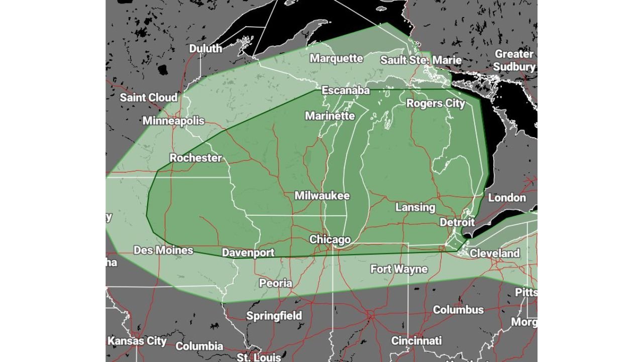
Illinois, Wisconsin, Michigan, and Minnesota Face Marginal Severe Weather Risk Monday With Damaging Winds and Large Hail Possible Across Chicago, Milwaukee, Detroit, Lansing, Green Bay, Marquette, and Duluth
UNITED STATES — Severe weather is possible across the Great Lakes region Monday, March 30, 2026, with a Marginal Risk (Level 1 of 5) in effect across a broad corridor stretching from Minnesota and Iowa through Illinois, Wisconsin, and Michigan. Cities including Chicago, Milwaukee, Detroit, Lansing, Green Bay, Marquette, and Duluth all fall within the risk zone today. Damaging winds and large hail are the primary threats — tornadoes are not expected to be a concern with this system.
What Is Driving Today’s Storm Threat
A weather system pushing across the Great Lakes region Monday is providing enough atmospheric lift and instability to support scattered severe thunderstorm development during the afternoon and evening hours.
The setup is not extreme — this is a Marginal Risk day, meaning severe weather will be isolated rather than widespread. Not every city in the risk zone will see storms, and many areas will stay completely dry. But those that do encounter a storm cell could see wind gusts strong enough to down trees and damage property, along with hail capable of denting vehicles and damaging crops.
Tornadoes are not anticipated with this setup. The wind shear profile across the Great Lakes Monday does not support significant rotation, keeping the tornado threat effectively off the table for today.
Cities in the Marginal Risk Zone Monday
| City | State | Risk Level |
|---|---|---|
| Chicago | Illinois | Marginal Risk |
| Milwaukee | Wisconsin | Marginal Risk |
| Detroit | Michigan | Marginal Risk |
| Lansing | Michigan | Marginal Risk |
| Green Bay | Wisconsin | Marginal Risk |
| Marquette | Michigan | Marginal Risk |
| Duluth | Minnesota | Marginal Risk |
| Davenport | Iowa | Marginal Risk |
| Peoria | Illinois | Marginal Risk |
| Fort Wayne | Indiana | Marginal Risk |
| Cleveland | Ohio | Marginal Risk |
| Rochester | Minnesota | Marginal Risk |
| Des Moines | Iowa | Marginal Risk |
Primary Hazards Today
Damaging winds are the headline threat Monday. Severe thunderstorm wind gusts of 58 mph or greater are possible with the strongest storm cells across the risk zone. Winds at these speeds are capable of snapping tree branches, downing power lines, and causing damage to structures — particularly older buildings and outbuildings.
Large hail is the second concern. Hail of one inch in diameter or larger is possible with any storm that manages to become severe. Vehicles parked outdoors, garden plants, and crops are all at risk from hail of this size.
Tornadoes are not expected — this is an important distinction from the Tuesday outlook. Wind shear values across the Great Lakes Monday are not sufficient to support significant storm rotation, making today primarily a damaging wind and hail event.
Forecast Confidence Level
High confidence on the Marginal Risk designation and geographic coverage — the risk zone is well-defined and consistent with available model data for Monday.
High confidence on damaging winds and hail as the sole primary hazards — tornado development is not anticipated with today’s atmospheric setup.
Medium confidence on exact storm timing and coverage** — storms will be isolated rather than widespread, meaning precise timing of individual cells is difficult to pinpoint at this stage.
What Great Lakes Residents Should Know Today
Storms will be isolated — but still dangerous. A Marginal Risk day does not mean the threat is trivial. A single severe thunderstorm producing 65 mph wind gusts or golf ball-sized hail can cause serious damage to whatever is directly in its path.
Move vehicles indoors or under cover before afternoon if large hail is a concern for your property — hail of one inch or larger can cause significant damage to vehicle surfaces and glass.
Stay weather-aware this afternoon and evening. The storm window opens during the afternoon heating hours and continues into the evening. Keep a weather alert method accessible throughout the day.
If a severe thunderstorm warning is issued for your county, move indoors immediately, stay away from windows, and avoid contact with plumbing and electrical systems until the warning expires.
Outdoor events in Chicago, Milwaukee, Detroit, and Green Bay should have a weather contingency plan in place before this afternoon.
The Bottom Line
The Great Lakes region faces a Marginal Risk for severe weather Monday, March 30, with damaging winds and large hail the primary concerns across Chicago, Milwaukee, Detroit, Lansing, Green Bay, Marquette, and Duluth. Storms will be isolated rather than widespread, and tornadoes are not anticipated. Stay weather aware this afternoon and evening — a single severe cell can still cause significant damage even on a low-risk day.
Stay ahead of dangerous weather before it reaches your door. Visit cabarrusweekly.com for daily severe weather coverage, storm alerts, and forecast updates from across the United States — because knowing early is the difference that matters.