Illinois, Wisconsin, Michigan, Iowa, Indiana, Ohio, and New York Face Severe Thunderstorm Threat Monday Night Through Tuesday as Pattern Change Brings Near-Daily Storm Risk Across the Plains and Eastern US Through Easter
UNITED STATES — A significant two-day severe thunderstorm threat is developing across the Great Lakes region starting Monday night, March 30 and continuing through Tuesday, March 31, 2026. Storms are expected to fire around sunset Monday and last through the overnight hours, with a second and more widespread round spreading eastward across the Great Lakes and Ohio Valley on Tuesday. This is also the beginning of a broader pattern change that forecasters warn will bring severe weather risks nearly every day across the Plains and Eastern United States through Easter weekend.
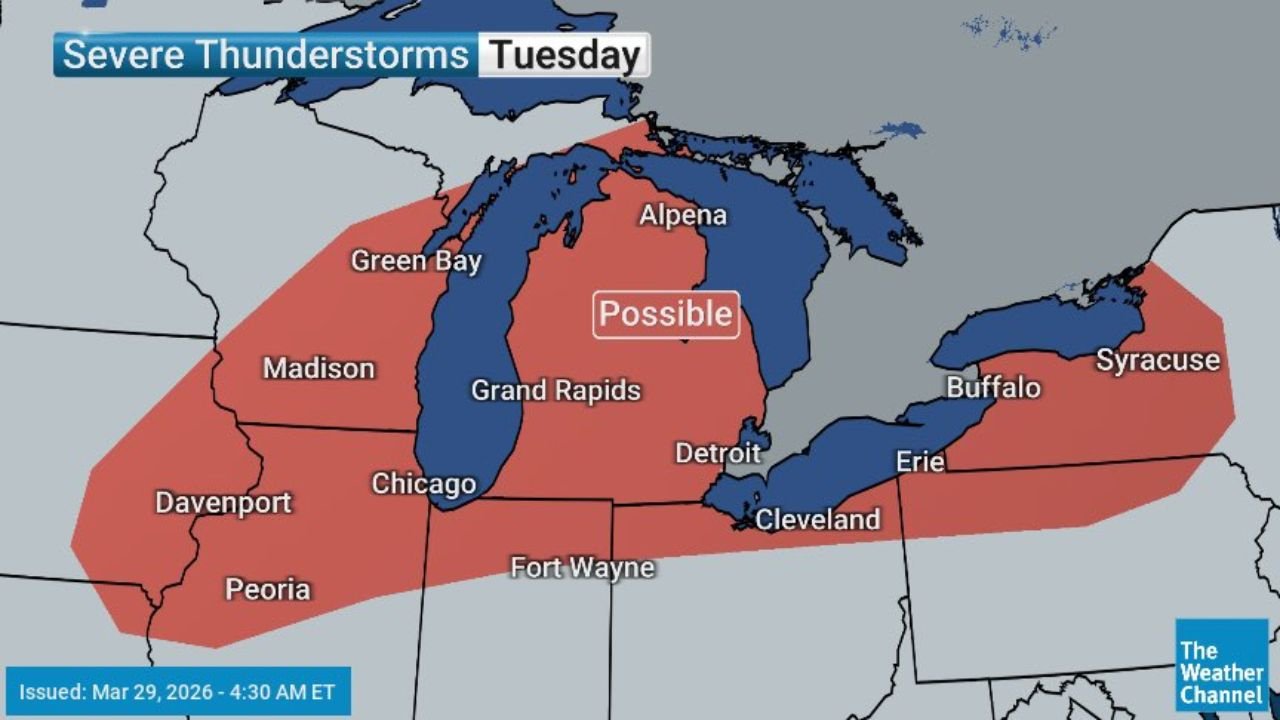
Both outlooks were issued March 29, 2026 at 4:30 AM ET.
How the Two-Day Event Unfolds
This is not two separate storm systems — it is one continuous weather event moving eastward across the Great Lakes corridor over 36 hours.
Monday night, March 30 — Thunderstorms develop around sunset across Wisconsin, northern Illinois, and Iowa. The storm window opens as daytime heating gives way to evening instability, allowing the first round of severe weather to fire along a corridor from La Crosse and Wausau through Green Bay, Milwaukee, Rockford, Chicago, and Davenport. Storms will last into the overnight hours before gradually pushing eastward.
Tuesday, March 31 — The threat expands significantly. The severe thunderstorm risk zone stretches from Davenport and Peoria through Chicago, Madison, Grand Rapids, Detroit, Cleveland, Erie, Buffalo, and Syracuse — a much larger geographic footprint than Monday night. Tuesday is the more significant of the two days, with the risk zone pushing well into the Ohio Valley and all the way to western New York.
Cities in the Monday Night Severe Thunderstorm Zone
| City | State |
|---|---|
| Chicago | Illinois |
| Milwaukee | Wisconsin |
| Green Bay | Wisconsin |
| Wausau | Wisconsin |
| Rockford | Illinois |
| La Crosse | Wisconsin |
| Baraboo | Wisconsin |
| Davenport | Iowa |
| Dubuque | Iowa |
| Waterloo | Iowa |
| Grand Rapids | Michigan |
| Kalamazoo | Michigan |
| Toledo | Ohio |
| Detroit | Michigan |
Cities in the Tuesday Severe Thunderstorm Zone
| City | State |
|---|---|
| Chicago | Illinois |
| Peoria | Illinois |
| Davenport | Iowa |
| Madison | Wisconsin |
| Green Bay | Wisconsin |
| Grand Rapids | Michigan |
| Detroit | Michigan |
| Fort Wayne | Indiana |
| Cleveland | Ohio |
| Erie | Pennsylvania |
| Buffalo | New York |
| Syracuse | New York |
| Alpena | Michigan |
The Bigger Picture — Severe Weather Nearly Every Day Through Easter
Monday night and Tuesday are not isolated events. They are the opening chapter of a prolonged and active severe weather pattern that forecasters expect to persist across the Plains and Eastern United States through Easter weekend.
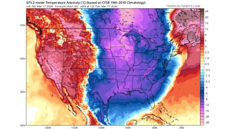
Upper-level atmospheric waves moving across the country in sequence will provide repeated triggers for storm development over the coming days. Gulf moisture is already building ahead of these systems, and with each passing day the fuel for severe weather will be increasingly in place across a wider area. Residents from the Plains through the Ohio Valley and into the Eastern United States should treat this not as a one-time storm event but as the start of a multi-day severe weather season stretch that will require daily attention through the holiday weekend.
Forecast Confidence Level
High confidence on severe thunderstorm potential Monday night across Wisconsin, Illinois, and Iowa — the timing and coverage are well-defined.
High confidence on Tuesday’s expanded risk zone across the Great Lakes and Ohio Valley — the eastward shift is consistent across available forecast data.
High confidence on the broader active pattern through Easter — multiple weather systems are lined up to move through the Plains and Eastern US over the coming days.
Medium confidence on exact storm timing Monday night** — storms firing around sunset can be difficult to time precisely. Residents should remain weather-aware from late afternoon onward rather than waiting for a specific hour.
What Residents Must Do Before Sunset Monday
Have your severe weather alert system active before Monday evening. Storms developing around sunset can move quickly and produce damaging winds, large hail, and isolated tornadoes with limited warning time. Do not wait for a warning to be issued before checking conditions — stay ahead of the storms.
Secure outdoor items before Monday afternoon. Wind gusts with severe thunderstorms can exceed 60 mph — enough to send patio furniture, trash cans, and lightweight objects airborne.
Know your shelter location now. An interior room on the lowest floor of a sturdy building, away from windows, is your safest option during a tornado warning. Identify that location at home and at work before the storms arrive.
Tuesday carries more risk than Monday night — residents across Detroit, Cleveland, Buffalo, and Syracuse face their highest threat on Tuesday as the system expands eastward. Monitor Monday evening forecasts closely for updated Tuesday guidance.
Plan for near-daily storm awareness through Easter. This is not a one-week event you can forget about after Tuesday. The Plains and Eastern US are entering an extended active pattern — keep your weather alert methods active and check forecasts daily through the holiday weekend.
The Bottom Line
Severe thunderstorms are possible across the Great Lakes, Ohio Valley, and western New York starting Monday night and continuing through Tuesday. Chicago, Milwaukee, Green Bay, Detroit, Cleveland, Buffalo, and Syracuse are all within the threat zone across the two-day period. More importantly, Monday night marks the beginning of a prolonged active severe weather pattern across the Plains and Eastern United States that forecasters expect to produce near-daily storm risks through Easter weekend. Stay weather-aware — this stretch is just getting started.
Stay ahead of dangerous weather before it reaches your door. Visit cabarrusweekly.com for daily severe weather coverage, storm alerts, and forecast updates from across the United States — because knowing early is the difference that matters.