Indiana and Ohio Snow Band Intensifies Near Fort Wayne Toward Columbus, With 1-Inch-Per-Hour Rates and Isolated 4+ Inch Totals Possible
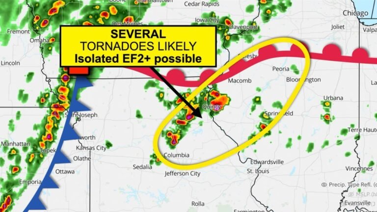
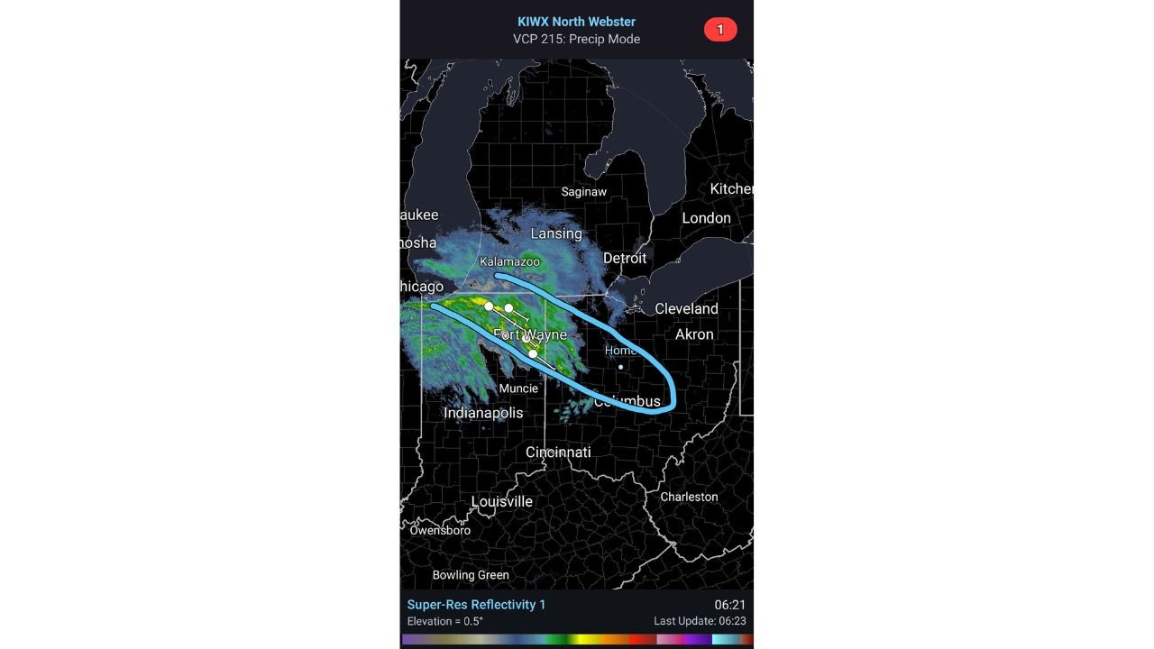
UNITED STATES — A strengthening snow band is taking shape across the Midwest this morning, with radar showing heavier returns lining up from northern Indiana near Fort Wayne east-southeast into central Ohio toward Columbus. Forecasters tracking the band say it appears to be aligning well with last evening’s model guidance—and if the band holds together, snowfall rates could exceed 1 inch per hour, leading to isolated totals topping 4 inches in the highlighted corridor.
Where the Heaviest Band Is Setting Up Right Now
The radar imagery highlights a narrow but organized zone of heavier precipitation extending from the Chicago area into northern Indiana, then continuing into Ohio.
The most notable corridor called out is centered on:
- Fort Wayne, Indiana as the core reference point
- A southeastward extension toward the Columbus, Ohio area
- With additional snow north of the band across parts of southern Michigan, including areas near Kalamazoo and Lansing
If you’re inside the narrow blue-highlighted zone, conditions can change fast—snow can go from light to intense within minutes when these bands tighten.
Why Isolated 4+ Inch Totals Are on the Table
The key line in the forecast note attached to the radar is the expected intensity: rates exceeding 1” per hour. You don’t need a long-duration storm to rack up totals when rates are that strong.
In practical terms:
- 2–3 hours of persistent heavy snow can quickly produce 3–4 inches
- Brief pulses can create whiteout-like visibility at times
- Roads can go from wet to snow-covered rapidly, especially on untreated routes
That’s why the word “isolated” matters here—some communities may get a quick 1–2 inches, while a town directly under the band could pick up 4+ inches before the band shifts.
Cities Most Likely to See Rapid Deterioration in Travel
Based on the placement shown:
- Fort Wayne, IN sits close to the heart of the band
- Communities east and southeast of Fort Wayne into western/central Ohio are in the potential path
- Columbus, OH is near the southeast end of the highlighted corridor, where the band could still deliver a burst of heavier snow if it holds together long enough
Meanwhile, areas north of the main band—toward Kalamazoo, Lansing, and Detroit—appear to be seeing lighter returns compared with the core strip, but could still get periods of snow as the system evolves.
What Drivers Should Expect in the Highlighted Corridor
If you’re traveling along this Fort Wayne-to-Columbus stripe, the main hazards are classic banded-snow problems:
- Sudden visibility drops in the heavier pockets
- Quick accumulation on bridges, overpasses, and untreated lanes
- Stop-and-go conditions as drivers hit the band edge and slow abruptly
- A higher chance of minor crashes and spinouts during the heaviest burst
Even if totals don’t look extreme on a regional map, the intensity matters more when rates spike above 1″/hr.
Why This Band Matters for Forecast Confidence
The note that this band is “aligning with last evening’s model runs” is important because it suggests the atmosphere is following a recognizable script—meaning short-term updates may now be able to narrow down where the most persistent strip sets up next.
That said, these bands still wobble. A shift of 10–20 miles can decide who gets the heavy snow and who stays in lighter flakes.
CabarrusWeekly.com will continue tracking major winter impacts nationwide that signal how active this pattern remains. If you’re in Indiana or Ohio and under this band, tell us what you’re seeing—are rates picking up, and are roads starting to cover?