Indiana and Western Ohio Face Light Rain/Snow Mix Wednesday Night Into Thursday Morning With Minor Accumulations and Slick Spot Risk
INDIANA — A weak weather disturbance will bring patchy light rain and snow to parts of the state Wednesday night into early Thursday, with minimal accumulation expected but a few slick spots possible for the morning commute.
Light Rain and Snow Mix Developing Overnight
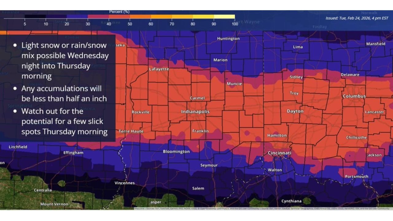
Forecast guidance shows light snow or a rain/snow mix possible Wednesday night into Thursday morning, especially across central and northern Indiana.
The highest probabilities for measurable snow extend from Lafayette through Indianapolis, Carmel, Muncie, and east toward Dayton and Columbus in Ohio. This corridor reflects the most consistent signal for light precipitation during the overnight hours.
Farther north toward Huntington, Lima, and Mansfield, probabilities remain present but vary depending on surface temperatures and precipitation type.
Snow Totals Expected to Stay Under Half an Inch
Any snowfall that does occur is expected to remain less than 0.5 inch, with many locations seeing only a dusting or brief slushy coating.
Areas including Rockville, Terre Haute, Bloomington, Franklin, and Muncie could see light accumulations on grassy and elevated surfaces. However, road temperatures and marginal air temperatures should limit widespread impacts.
The system lacks strong moisture and lift, keeping snowfall rates light and short-lived.
Slick Spots Possible for Early Thursday Travel
Despite low totals, untreated surfaces could develop a few slick spots early Thursday morning, particularly where precipitation briefly falls as snow before mixing with rain.
Bridges, overpasses, and secondary roads are the most likely areas for minor slick conditions, especially if temperatures dip near or just below freezing overnight.
Drivers in Indianapolis, Lafayette, Muncie, Dayton, and Columbus should remain alert during the morning commute, even though widespread hazardous travel is not anticipated.
Brief Event With Limited Impact
This setup appears to be a minor, short-duration event, with precipitation tapering off by late Thursday morning as the disturbance exits the region.
While measurable snow is possible in spots, the overall expectation remains for light accumulations and localized slick areas rather than significant winter impacts.
If you’re in Indiana or western Ohio, share what conditions look like in your area overnight and Thursday morning. Let us know about any slick roads or light accumulations at CabarrusWeekly.com.