Indiana, Illinois, Ohio Storms Intensify This Evening as 60 MPH Winds and Large Hail Track Toward Fort Wayne, Toledo, and Detroit
INDIANA — Strong to severe thunderstorms are actively developing and intensifying across northern Indiana, with a clear eastward track that will bring impacts into Ohio and southern Michigan through the evening hours.
Early reports already indicate wind gusts near 60 mph and hail up to quarter size, and there are growing concerns that storms could strengthen further as they continue moving east.
Storms Already Active Across Northern Indiana and Illinois
Storm clusters are currently ongoing across parts of:
- Northern Illinois (including areas near Chicago)
- Northern and central Indiana
- Extending west toward east-central Illinois
These storms are forming along a corridor favorable for organization, with multiple cells merging and producing frequent lightning, heavy rain, and strong wind bursts.
Clear Eastward Track Toward Ohio and Michigan
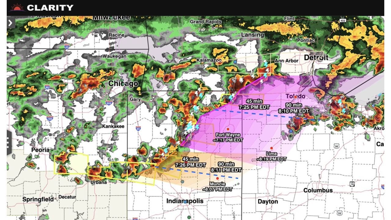
Tracking projections show storms moving steadily east with the following general timing:
- Fort Wayne, Indiana: Around 7:15–7:30 PM EDT
- Muncie and surrounding areas: Around 8:00–8:15 PM EDT
- Toledo, Ohio: Near 8:10 PM EDT
- Lima, Ohio: Around 8:15–8:20 PM EDT
Farther north, storms are also pushing toward:
- Southern Michigan, including areas near Detroit
This indicates a multi-state progression, with impacts spreading quickly across the region during the evening commute and early nighttime hours.
Damaging Winds and Large Hail Main Threats
The primary hazards with these storms include:
- Wind gusts approaching or exceeding 60 mph
- Large hail up to quarter size or larger
- Frequent lightning and localized heavy downpours
As storms consolidate into stronger clusters or lines, the wind threat may become more widespread, especially in areas east of current activity.
Potential for Further Intensification
There are increasing signals that storms could:
- Strengthen as they move into Ohio and southern Michigan
- Organize into a more continuous line
- Produce more consistent damaging wind reports
This is especially important for areas downwind of current storms, where atmospheric conditions remain favorable.
Areas That Should Monitor Closely
Communities across the following regions should remain alert:
- Northern and eastern Indiana
- Western and northern Ohio
- Southern Michigan, including Detroit metro
Storms are expected to arrive quickly, with limited lead time between development and impact.
Rapidly Changing Conditions Through the Evening
Because these storms are moving at a steady pace:
- Conditions can deteriorate quickly
- Strong winds may arrive suddenly
- Visibility may drop rapidly in heavy rain
Residents should be prepared for fast-changing weather conditions through the evening hours.
Bottom Line
An active line of strong to severe storms is moving from Illinois through Indiana and into Ohio and Michigan, bringing damaging winds, large hail, and intense lightning.
With storms expected to continue strengthening as they move east, this evening could bring widespread impacts across multiple states in a short period of time.
Stay with CabarrusWeekly.com for real-time updates as this storm system continues to evolve.