Indiana Ohio Pennsylvania Rain Surge Late March Brings 1 To 2 Inches With Flood Risk Rising As Thursday Storms Move Through
INDIANA — A wetter pattern is setting up across the region to close out March, with multiple rounds of rain expected to bring widespread totals of 1 to 2 inches, and locally higher amounts possible.
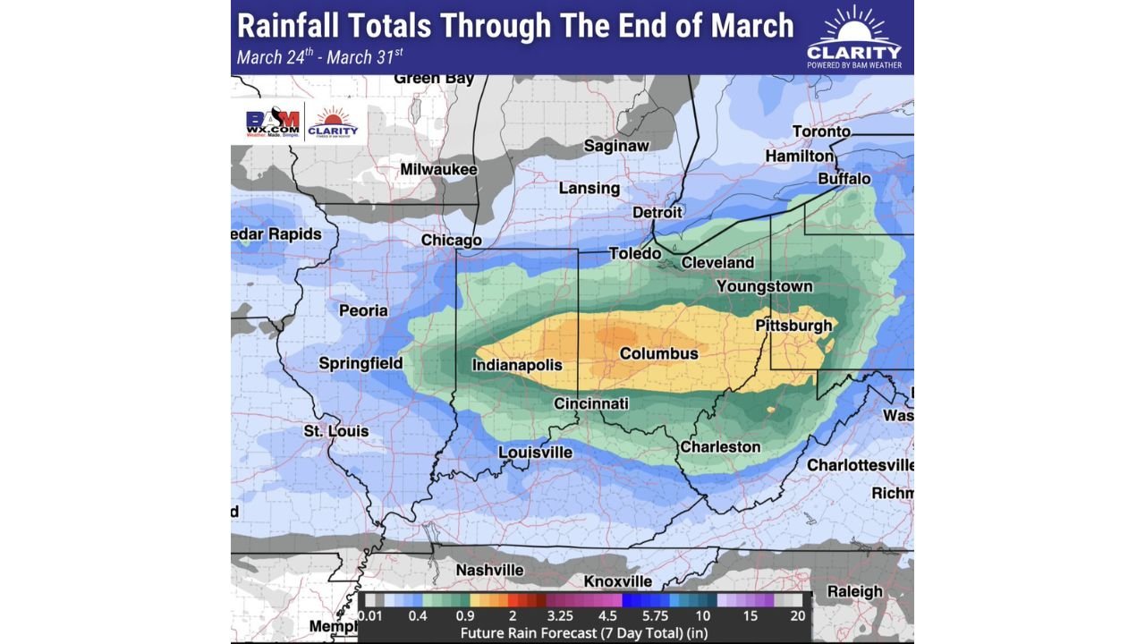
Forecast data shows the heaviest rainfall corridor stretching from central Indiana through Ohio into western Pennsylvania, where the greatest impacts are expected.
Heaviest Rain Targets Indiana Ohio And Western Pennsylvania
The latest rainfall projections indicate:
- 1 to 2 inches of rain likely across a broad zone
- Locally higher totals possible where storms repeatedly track
- A focused corridor from Indianapolis → Columbus → Pittsburgh
Cities most likely to see heavier totals include:
- Indianapolis, Indiana
- Cincinnati and Columbus, Ohio
- Cleveland and Youngstown, Ohio
- Pittsburgh, Pennsylvania
This band of heavier rain suggests a consistent storm track setting up across the Ohio Valley into western Pennsylvania.
Thursday Expected To Bring Peak Rainfall
While rain may occur over multiple days, Thursday stands out as the main impact day.
Key expectations for Thursday:
- Storms moving through the region in waves
- Periods of moderate to heavy rainfall
- Potential for training storms, where multiple cells pass over the same areas
This setup increases the risk that some locations could quickly exceed the 1–2 inch forecast range.
Flooding Risk Begins To Increase
With repeated rainfall and already moist ground conditions in some areas, localized flooding becomes a concern.
Areas most vulnerable include:
- Urban locations with poor drainage
- Low-lying and flood-prone zones
- Areas experiencing back-to-back storm rounds
Even though widespread major flooding is not guaranteed, isolated flooding issues are likely, especially during heavier downpours.
Rainfall Gradient Across The Region
Not all areas will see the same totals. The forecast shows:
- Highest totals (1–2+ inches): Central Indiana → Ohio → Western Pennsylvania
- Moderate totals: Surrounding Midwest and parts of the Great Lakes
- Lower totals: Areas farther south and north outside the main storm track
This gradient highlights a well-defined storm corridor, which will dictate where the biggest impacts occur.
Storm System Driving The Pattern
The wet pattern is being driven by:
- A storm system moving along a frontal boundary
- Moisture streaming northward into the Ohio Valley
- Repeated disturbances tracking along the same path
This combination is what supports persistent rainfall rather than a single quick-moving event.
Final Outlook
The end of March is shaping up to be active and wet across Indiana, Ohio, and western Pennsylvania, with Thursday expected to deliver the bulk of the rainfall and highest flooding risk.
Residents should stay alert for changing conditions, especially in areas prone to flooding, as even a few hours of heavy rain could create localized issues quickly.
Stay with CabarrusWeekly.com for continued updates as this late-March rain event unfolds.