Initial Snow Threat Map Highlights High-Impact Corridor From Maryland to Maine as Northeast Storm Develops
UNITED STATES — An early-stage storm assessment is outlining a potentially significant snowfall corridor stretching from the Mid-Atlantic into New England as a developing system begins to organize offshore.
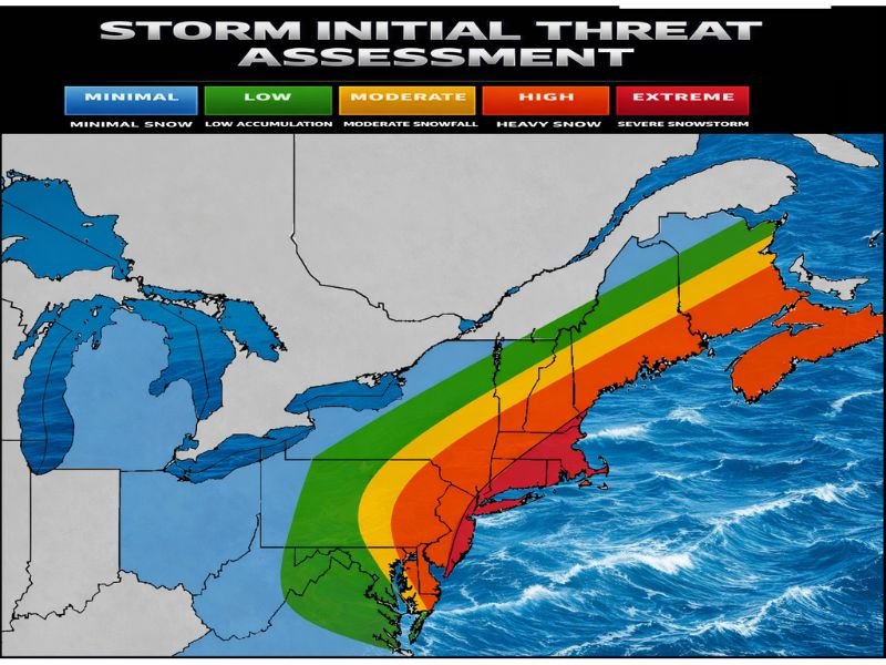
The preliminary “Storm Initial Threat Assessment” identifies where confidence is currently highest for heavier snowfall totals, based on model guidance, projected storm track, and the evolving synoptic setup. While this is not a finalized forecast, the highlighted zone shows where the greatest potential exists for impactful accumulation.
Highest Snowfall Threat Focused From Mid-Atlantic to Northern New England
The shaded map places the most significant snow potential in a sweeping arc that includes:
- Eastern Maryland
- Delaware
- Southern and central New Jersey
- New York City and Long Island
- Southern and eastern New York State
- Connecticut
- Rhode Island
- Massachusetts
- Vermont
- New Hampshire
- Maine
Within this corridor, warmer colors on the map — including orange and red — indicate higher confidence in heavier snowfall rates and more substantial totals.
The red-shaded areas, particularly across parts of coastal New Jersey, the New York City metro, Long Island, and into southern New England, represent the zone currently favored for the most significant impacts.
Moderate Snow Zone Extends Inland
Surrounding the core heavy band is a broader moderate snowfall region, shown in yellow and green, stretching into:
- Eastern Pennsylvania
- Upstate New York
- Interior New England
- Portions of western Maryland and northern Virginia
These areas may still see plowable snowfall, though the gradient between moderate and heavier totals could be sharp depending on the exact storm track.
Farther west into Ohio and the Great Lakes, the map indicates lower snow potential, suggesting the heaviest precipitation will remain tied to the coastal and near-coastal storm evolution.
Early Assessment, Track Still Critical
Forecasters emphasize that this is an initial outlook and reflects current model consensus. Small shifts in the storm’s path or intensity could significantly alter where the heaviest band ultimately sets up.
If the surface low tracks slightly farther east, coastal totals could decrease while inland areas see more snow. Conversely, a closer coastal track could enhance snowfall rates and increase impacts in major metropolitan areas.
Potential Impacts If Heavier Band Verifies
If the highlighted high-threat zone materializes as currently indicated, impacts may include:
- Hazardous travel due to rapid snow accumulation
- Reduced visibility during heavier bursts
- Localized power outages where gusty winds combine with heavier snow rates
- Difficult Monday morning commute conditions in urban corridors
Additional refinements, including more detailed snowfall projections and timing breakdowns, are expected as confidence improves. For continued updates on this developing Northeast storm and its potential impacts, stay connected with CabarrusWeekly.com for the latest analysis and coverage.