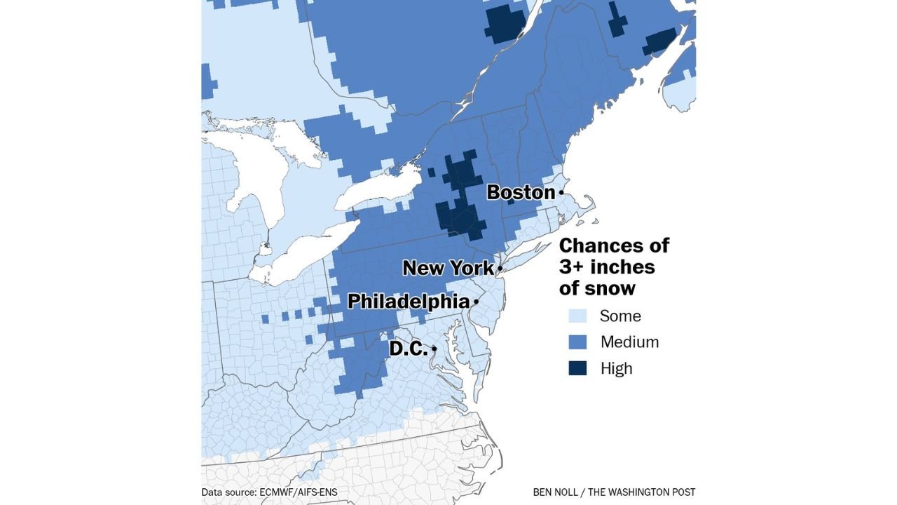
Inland Northeast from Pennsylvania to Upstate New York and New England Shows Higher Odds for 3+ Inches of Snow Early Next Week
NORTHEAST UNITED STATES — Another round of snow may target the region early next week, with current model guidance suggesting inland areas are more likely to see meaningful accumulation than the immediate coastline.
Inland Corridor Favored Over Coastal Cities
Preliminary ensemble data highlights the greatest probability for 3 or more inches of snowfall stretching from parts of central and western Pennsylvania through upstate New York and into interior New England.
The higher-probability zone appears displaced west of the I-95 corridor, indicating that storms tracking in from the west may keep the heaviest snow inland rather than along the Atlantic coast.
Major metropolitan areas including New York City, Boston, and Philadelphia remain within the broader zone of potential accumulation, but the highest odds currently sit north and west of those urban cores.
Medium to High Probabilities in Interior Zones
Shaded probability guidance shows:
Medium chances of 3+ inches across much of upstate New York and interior Pennsylvania.
Higher localized probabilities in portions of central New York and parts of interior New England.
Lower but still present chances extending southward toward Washington, D.C., and parts of Maryland and northern Virginia.
This pattern suggests that while snow is possible across a broad swath of the Northeast, the most reliable setup for moderate accumulation favors areas away from the immediate coast.
Storm Track Key to Final Outcome
Forecast confidence remains limited this far out, and subtle shifts in storm track could significantly alter who sees accumulating snow.
If the system tracks farther east, coastal cities like Boston, New York, and Philadelphia could see higher totals. A more inland track, however, would continue to favor upstate New York, interior Pennsylvania, and western New England.
With early-week timing still several days away, refinements in model guidance are expected.
What to Watch in the Coming Days
Key factors that will determine snowfall placement include:
Exact storm track
Temperature profiles near the coast
Strength of cold air in place ahead of the system
At this stage, the signal supports at least some potential for accumulating snow across the inland Northeast, while coastal impacts remain more uncertain.
Residents from Washington, D.C., through Philadelphia, New York, and Boston should monitor updated forecasts over the weekend as details become clearer.
If you’re in the Northeast, keep us updated on forecast changes and local preparations. Share what you’re seeing in your area at CabarrusWeekly.com as this early-week system develops.