Iowa, Illinois and Wisconsin Could See Early Evening Supercell Development Near Quad Cities With Increasing Tornado Signals in Forecast Soundings
ILLINOIS — A developing severe weather setup near the Quad Cities is drawing attention this afternoon, where forecast soundings indicate strengthening tornado signals as storms begin to organize across eastern Iowa and western Illinois.
Quad Cities Region Emerges as Key Focus Area
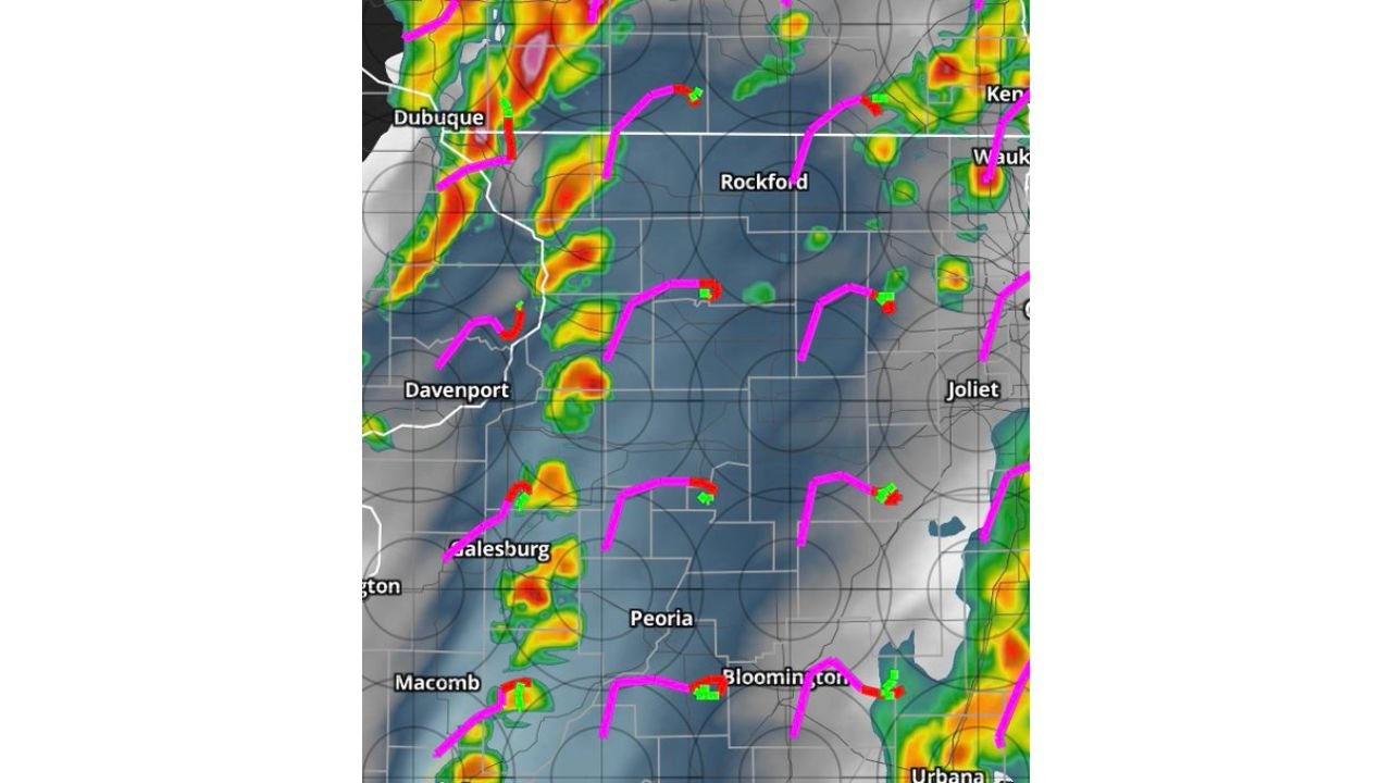
The area around Davenport, extending into parts of western Illinois including Galesburg and Peoria, is becoming a focal point for storm development later this afternoon into early evening.
Recent model trends suggest storms may begin forming slightly earlier than expected, increasing the window for instability to build and support stronger storm structures.
Forecast Soundings Show Strong Rotation Potential
Detailed atmospheric profiles in the region show increasing low-level wind shear and strong storm-relative inflow, both of which are critical ingredients for rotating thunderstorms.
These signals point toward an environment capable of supporting supercell-like structures, even if storms remain somewhat scattered in nature.
Mini Supercell Structures Possible Across Illinois
High-resolution models are indicating the potential for smaller, discrete supercells developing across parts of Illinois, particularly between Davenport, Peoria, and areas east toward Bloomington.
These storms may not form into a solid line initially, which increases concern for localized rotation and isolated tornado potential within individual cells.
Storm Coverage Remains Scattered but Impactful
Radar projections suggest storms will remain somewhat scattered across the region rather than forming a widespread line early on. This scattered nature allows storms to develop independently and potentially intensify more efficiently.
Areas near Rockford and into southern Wisconsin could also see isolated storms capable of brief rotation and gusty winds.
Timing Shifts Toward Earlier Development Window
One notable trend in recent data is the earlier clearing of afternoon convection, which may allow storms to develop sooner than previously expected.
This shift increases the risk that storms will have more time to strengthen before sunset, when atmospheric conditions remain favorable for severe weather.
What Residents Should Watch This Evening
Communities across eastern Iowa, western Illinois, and southern Wisconsin should stay alert through the late afternoon and evening. Even though storms may be scattered, any storm that develops could quickly become severe with rotation.
Localized impacts such as brief tornadoes, strong wind gusts, and lightning remain possible, especially in and around the Quad Cities corridor.
Stay with CabarrusWeekly.com for continued updates and share what you’re seeing in your area as storms begin to develop this evening.