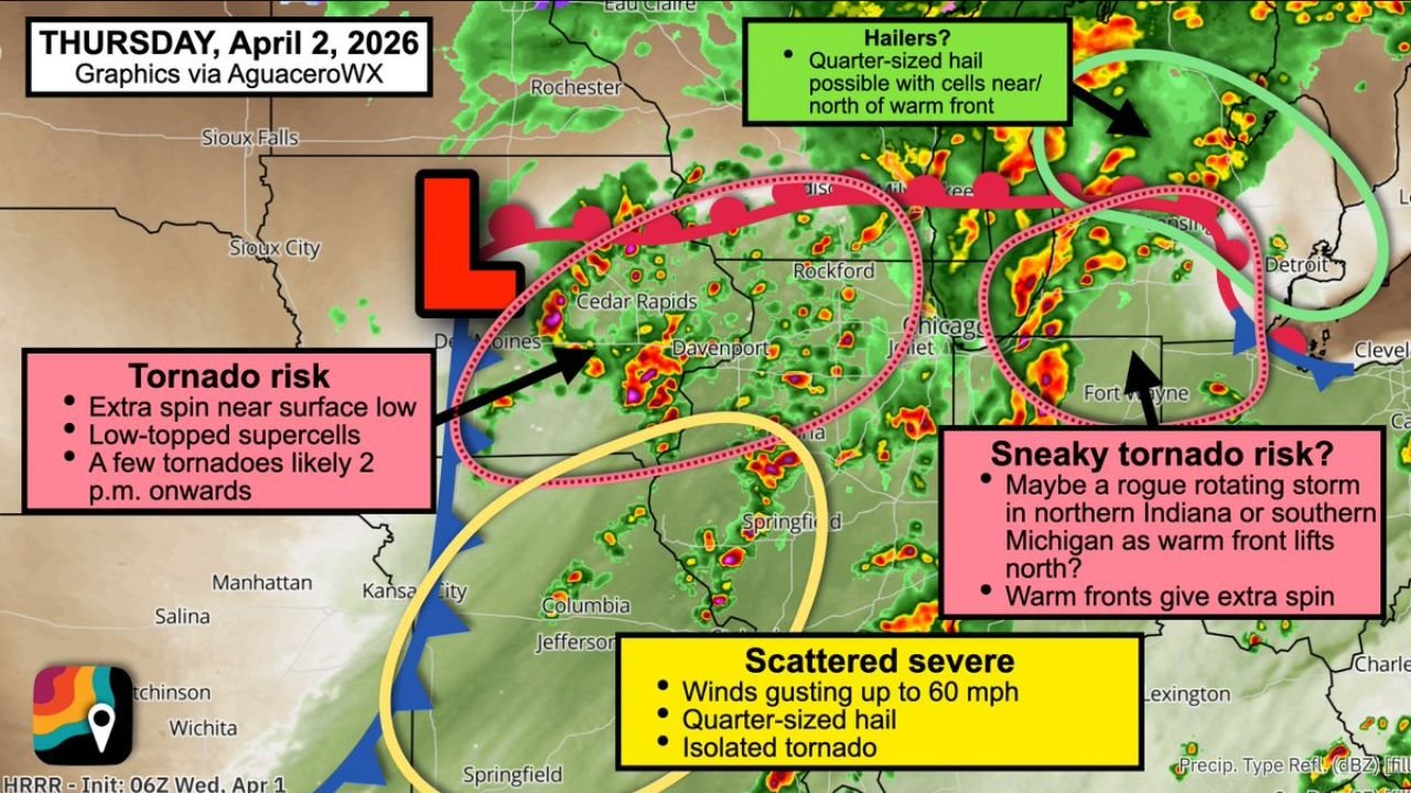
Iowa, Illinois, Indiana, and Michigan Face Four-Zone Severe Weather Thursday With Low-Topped Supercell Tornadoes, Warm Front Spin, and 60 MPH Winds From Des Moines to Chicago Starting at 2 PM
UNITED STATES — Thursday, April 2, 2026 is shaping up to be one of the more meteorologically complex severe weather days of this already historic week. A four-zone severe weather setup is developing across the Corn Belt and Great Lakes — with each zone carrying its own distinct threat profile and its own atmospheric driver. Low-topped supercells capable of producing tornadoes are expected to fire from 2 PM onwards across southeast Iowa, northwest Illinois, and extreme southern Wisconsin. A sneaky and less-anticipated tornado risk is simultaneously developing across northern Indiana and southern Michigan as a warm front lifts northward. Quarter-sized hail threatens the Milwaukee and Detroit corridor. And scattered severe thunderstorms with 60 mph wind gusts are targeting Missouri and southwest Illinois through the afternoon and evening.
This forecast is based on the HRRR model initialized April 1, 2026 at 06z, valid Thursday, April 2, 2026.
The Setup — A Deepening Low Pressure and an Uncertain Morning
Thursday’s severe weather story begins with a low pressure system ejecting from Kansas into Iowa while slowly deepening and strengthening through the morning hours. This strengthening low is the engine behind all four of Thursday’s severe weather zones — providing the vorticity, lift, and wind shear that each zone will tap into differently depending on its position relative to the low and the associated frontal boundaries.
The critical uncertainty heading into Thursday is the same one that has been flagged since Wednesday — whether Wednesday night’s leftover storms consume too much of the atmospheric instability before Thursday afternoon arrives. If overnight and morning convection is too aggressive, it could deplete the fuel needed for afternoon supercell development across the primary tornado risk zone.
However, if the atmosphere gets even a partial recovery window — some sunshine breaking through and heating the surface across southeast Iowa, northwest Illinois, and southern Wisconsin — the conditions for rotating low-topped supercells snap into place quickly. With ample vorticity spinning near the surface low, even relatively shallow thunderstorms in this environment can develop significant rotation and produce tornadoes.
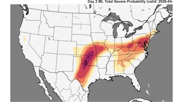
Zone One — The Primary Tornado Risk: Des Moines to Chicago Corridor
The highest tornado concern Thursday is centered over a pink zone stretching from Des Moines and Cedar Rapids southeastward through Davenport, Rockford, and into the Chicago and Joliet corridor.
The tornado mechanism here is unusual and worth understanding — low-topped supercells. Traditional tornado-producing supercells are tall, deep storm structures that extend high into the atmosphere. Low-topped supercells are shorter, shallower storms — but they can be just as dangerous for tornadoes because they develop in environments with intense low-level wind shear and strong surface vorticity that compensates for the lack of height.
Near the surface low tracking from Kansas into Iowa Thursday, the atmospheric spin at the lowest levels of the atmosphere is unusually strong. Any thunderstorm that develops in this environment and taps into that near-surface vorticity can rotate efficiently — even without the classic tall supercell structure. The result is a tornado threat that can be harder to anticipate visually and on radar because the storms producing it do not look like the classic severe thunderstorm signature that most people associate with tornado risk.
Tornadoes are likely to develop from 2 PM onwards across this zone — as daytime heating peaks and the surface low reaches its closest approach to the risk area. Residents from Des Moines through Cedar Rapids, Davenport, Rockford, and into the Chicago metro should be in full severe weather ready mode by early afternoon — not waiting until the 2 PM window arrives.
Zone Two — The Sneaky Tornado Risk: Northern Indiana and Southern Michigan
The second and perhaps more surprising tornado risk Thursday develops across northern Indiana and extreme northwest Ohio and southern Michigan — a zone that has received less attention than the Iowa-Illinois corridor but carries a genuine and distinct tornado threat through a different atmospheric mechanism.
As the low pressure system approaches from the west Thursday, the stationary front that has been draped across the region lifts northward as a warm front. This warm front lifting is significant for tornado potential in ways that are not always obvious.
When a warm front lifts northward, it creates a zone of enhanced low-level helicity — the atmospheric measure of horizontal spinning motion in the lower atmosphere that can be tilted into the vertical by a rising thunderstorm updraft to produce tornado-producing rotation. Warm fronts are prolific generators of this low-level helicity because the wind direction changes sharply across the boundary — creating exactly the type of wind shear profile that spinning thunderstorm updrafts need.
A rogue rotating storm developing in northern Indiana or southern Michigan as the warm front lifts north could tap into this enhanced helicity and become tornadic — potentially with limited warning time because these warm-front tornado setups can produce tornadoes that form quickly and are difficult to track on radar given the low-topped nature of the storms.
Residents across Fort Wayne, South Bend, Elkhart, and the northern Indiana corridor — as well as Kalamazoo, Battle Creek, and southern Michigan communities — should treat Thursday as a genuine tornado awareness day even though their zone is not the primary focus of the outlook.
Zone Three — Quarter-Sized Hail: Milwaukee and Detroit Corridor
North of the warm front across the Milwaukee, Grand Rapids, Lansing, and Detroit corridor, a different and simpler threat is in place Thursday. Storms developing in this zone will be north of the frontal boundary — meaning they will be operating in cooler surface air that limits tornado potential but still supports storm development capable of producing quarter-sized hail.
Quarter-sized hail — approximately one inch in diameter — is large enough to cause windshield damage on vehicles, dent aluminum siding, and damage outdoor equipment and plants. The cooler surface air in this zone means tornado development is not anticipated, but the hail threat is real for residents across the northern Great Lakes corridor Thursday.
Zone Four — Scattered Severe: Missouri and Southwest Illinois
The fourth zone Thursday covers Missouri and southwest Illinois — where the yellow zone on the outlook map indicates more scattered strong to severe thunderstorms with a different threat profile than the tornado-focused zones to the north.
The primary concerns across Missouri and southwest Illinois Thursday are locally damaging wind gusts up to 60 mph and quarter-sized hail with the strongest storm cells. An isolated tornado cannot be completely ruled out across this zone — but the main hazards are wind and hail rather than the organized tornado threat present further north.
Kansas City, Columbia, Jefferson City, St. Louis, and Springfield are all within or near this scattered severe zone Thursday afternoon and evening.
Four-Zone Threat Summary — Thursday April 2
| Zone | Location | Threats | Timing |
|---|---|---|---|
| Zone 1 — Pink | Des Moines, Cedar Rapids, Davenport, Rockford, Chicago | Low-topped supercells, tornadoes likely | 2 PM onwards |
| Zone 2 — Sneaky | Northern Indiana, Southern Michigan | Warm front tornado risk, rotating supercell possible | Afternoon-evening |
| Zone 3 — Green | Milwaukee, Grand Rapids, Detroit | Quarter-sized hail, no tornado risk | Afternoon |
| Zone 4 — Yellow | Missouri, Southwest Illinois | 60 mph gusts, quarter-sized hail, isolated tornado | Afternoon-evening |
Forecast Confidence Level
High confidence on tornado development from 2 PM onwards across the Des Moines to Chicago corridor — if even partial air mass recovery occurs Thursday morning, the low-topped supercell environment near the surface low is well-established.
High confidence on the sneaky warm front tornado risk across northern Indiana and southern Michigan** — the helicity enhancement from the warm front lifting is a reliable and well-documented tornado mechanism.
Medium confidence on the morning air mass recovery question** — this remains the primary uncertainty. If Wednesday night’s storms consume too much instability, the afternoon tornado potential is reduced. Thursday morning forecasts will be critical.
High confidence on quarter-sized hail across the Milwaukee and Detroit corridor** — the hail-producing environment north of the front is well-defined and consistent.
High confidence on 60 mph wind gusts across Missouri and southwest Illinois** — the scattered severe environment across this zone is locked in regardless of the air mass recovery question.
What Residents in Each Zone Must Do
Des Moines, Cedar Rapids, Davenport, Rockford, and Chicago residents in Zone 1 face the highest tornado risk Thursday. The 2 PM timing means the danger window arrives during early afternoon hours — be in your shelter plan before noon. Low-topped supercell tornadoes can develop quickly and may not have the classic visual appearance of a large, visible funnel. Do not rely on seeing a tornado to know one is coming — rely on your alerts.
Northern Indiana residents — Fort Wayne, South Bend, Elkhart, and surrounding communities — face the sneaky warm front tornado risk that has received less attention than the Iowa-Illinois corridor. Do not assume you are in a safer zone simply because the headline focus is elsewhere. The warm front tornado mechanism is real and the helicity values across your region Thursday are genuinely concerning.
Southern Michigan residents — Kalamazoo, Battle Creek, and surrounding areas — face the same warm front tornado risk as northern Indiana. Keep alerts active Thursday afternoon and have a shelter plan ready even if your area is not prominently featured in the primary severe weather headlines.
Milwaukee and Detroit corridor residents in Zone 3 — your primary concern Thursday is quarter-sized hail. Move vehicles to covered parking if possible before storms arrive Thursday afternoon. The cooler air north of the front means tornado development is not anticipated in your zone, but hail damage to unprotected vehicles is a real risk.
Missouri and southwest Illinois residents in Zone 4 — 60 mph wind gusts are capable of causing significant tree and property damage across Kansas City, Columbia, St. Louis, and surrounding communities. Secure outdoor property before Thursday afternoon and keep alerts active through the evening hours.
The Bottom Line
Thursday, April 2 brings a four-zone severe weather outbreak across the Corn Belt and Great Lakes — with each zone carrying its own distinct and dangerous threat profile. Low-topped supercells capable of producing tornadoes are expected from 2 PM onwards across the Des Moines to Chicago corridor. A sneaky warm front tornado risk threatens northern Indiana and southern Michigan as the front lifts north and enhances low-level helicity. Quarter-sized hail targets the Milwaukee and Detroit corridor. And 60 mph wind gusts are forecast across Missouri and southwest Illinois. Thursday’s setup is complex, multi-faceted, and demands zone-specific awareness — know which zone you are in, know your threat, and be ready well before 2 PM.
Stay ahead of dangerous weather before it reaches your door. Visit cabarrusweekly.com for daily severe weather coverage, tornado outlooks, and storm alerts from across the United States — because knowing early is the difference that matters.