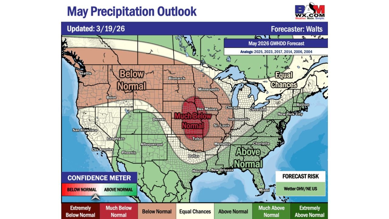
Iowa, Illinois, Indiana, Missouri, Kansas, Nebraska, and the Central Plains Face Much Below Normal Precipitation in May 2026 While Southeast, Ohio Valley, and Northeast Trend Wetter Than Normal
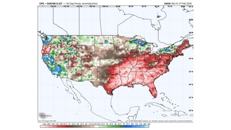
UNITED STATES — The May 2026 precipitation outlook is signaling a dramatic pattern shift across the United States compared to the active and wet April that preceded it. A much below normal precipitation zone is developing across the heart of the central United States — centered directly over Iowa, Illinois, Indiana, Missouri, Kansas, and Nebraska — while the Southeast, Ohio Valley, and Northeast are forecast to see above normal rainfall through the month. The West and Northwest continue their drier than normal trend into May.
The May Pattern — A Sharp Reversal for the Central US
May 2026 looks nothing like April 2026 for the central United States. The same corridor that is being drenched with heavy rainfall through early to mid-April — the Mississippi Valley, Ohio Valley, and central Plains — is forecast to flip to a much below normal precipitation pattern by May.
The core of the dry signal is centered over Des Moines, Chicago, St. Louis, Indianapolis, Tulsa, and Memphis — a much below normal zone that represents a significant departure from what May typically delivers across this part of the country. Surrounding that core, a broader below normal zone extends through the central and western Plains, the Mountain West, and the Pacific Northwest.
Meanwhile, the Southeast and Gulf Coast continue their wet pattern into May, with above normal precipitation forecast from Houston and New Orleans through Atlanta, Charlotte, and up into the Ohio Valley and Northeast.
May 2026 Precipitation Outlook by Region
| Region | Precipitation Outlook |
|---|---|
| Des Moines / Chicago / St. Louis | Much Below Normal |
| Indianapolis / Tulsa / Memphis | Much Below Normal |
| Kansas / Nebraska / Iowa core | Much Below Normal |
| Denver / Albuquerque / Plains | Below Normal |
| Seattle / Boise / Northwest | Below Normal |
| Houston / New Orleans / Atlanta | Above Normal |
| Charlotte / Ohio Valley | Above Normal |
| New York / Boston / Northeast | Above Normal |
| Cleveland / Pittsburgh | Above Normal |
| Great Lakes / New England | Equal Chances |
| Miami / Southeast coast | Above Normal |
What Much Below Normal Actually Means in May
May is one of the most important precipitation months of the year across the central United States. It is the month when corn and soybean planting gets underway across Iowa, Illinois, Indiana, and Missouri — crops that depend on adequate soil moisture to establish strong root systems early in the growing season.
A much below normal May across this agricultural corridor has direct implications for the 2026 growing season. Soils that are currently saturated from the heavy April rains will dry out rapidly if May delivers significantly below normal rainfall — potentially creating drought stress during the critical planting window even after a very wet April.
For cities like Chicago, St. Louis, Indianapolis, and Des Moines, a much below normal May also means a drier and more comfortable late spring — fewer severe weather days, lower humidity, and more outdoor-friendly conditions compared to the active April pattern.
The Forecast Risk — Wetter Ohio Valley and Northeast
The forecast risk for May points toward a wetter outcome across the Ohio Valley and Northeastern United States — meaning Cleveland, Pittsburgh, Philadelphia, New York, and Boston could see even more above normal rainfall than the base forecast suggests if the risk materializes.
This is worth noting for residents along the East Coast heading into late spring. A wetter than normal May across the Northeast, coming on the heels of an active April, raises the longer-term concern for river flooding and saturated ground conditions across the mid-Atlantic and New England states.
Analog Years and What They Suggest
The May 2026 forecast is built on analog years — past years with similar atmospheric patterns that provide a blueprint for how May might unfold. The analogs used are 2025, 2023, 2017, 2014, 2006, and 2004.
Several of these analog years featured active severe weather seasons across the Southeast and Ohio Valley during May, consistent with the above normal precipitation signal forecast for those regions. The central Plains analog years also support the drier signal — multiple analog years featured early season drying across Iowa, Illinois, and Missouri after wet spring periods.
Forecast Confidence Level
Medium confidence overall on the May outlook — forecasts at the one-to-two month range carry significant uncertainty, and analog-based forecasts can shift as closer-range data becomes available.
Higher confidence on the much below normal signal for the central Plains core — the analog years and model data are in consistent agreement on the dry signal for Iowa, Illinois, Indiana, and Missouri.
Medium confidence on above normal precipitation across the Southeast and Ohio Valley — the wet signal is supported by multiple analogs but exact geographic boundaries will sharpen considerably as May approaches.
The Bottom Line
May 2026 is shaping up to bring a sharp precipitation reversal across the central United States. The much below normal zone centered over Iowa, Illinois, Indiana, Missouri, Kansas, and Nebraska signals a drier and potentially drought-developing pattern across the agricultural heartland during the critical planting season. Meanwhile, the Southeast, Ohio Valley, and Northeast remain in an above normal precipitation pattern through May — with the forecast risk skewing even wetter across the Ohio Valley and New England. The wet April and dry May combination across the central US is a setup worth watching closely as the growing season gets underway.
Stay ahead of seasonal weather patterns before they impact your area. Visit cabarrusweekly.com for extended range outlooks, drought monitoring, and precipitation forecasts from across the United States — because knowing early is the difference that matters.