Iowa, Illinois, Wisconsin Face Overnight Elevated Storms With Egg-Sized Hail Risk as Frontal Boundary Triggers Severe Setup
IOWA — A targeted overnight severe weather setup is expected across parts of the Midwest, where elevated thunderstorms developing north of a frontal boundary could produce large to damaging hail, especially late Monday into early Tuesday.
Elevated Storms Develop Along Frontal Boundary Tonight
The setup tonight is driven by storms forming above a shallow layer of cool, dense air north of a frontal boundary, creating what meteorologists call elevated convection.
These storms are expected to develop across Iowa by late evening, then spread east into northwest Illinois and southern Wisconsin overnight.
Because the storms are elevated, they are less likely to tap into surface-based instability, which significantly reduces tornado potential.
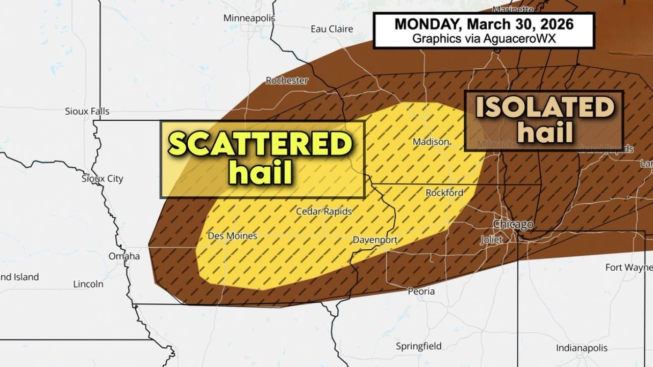
Scattered Hail Threat Across Key Midwest Corridor
The primary concern with this system is scattered hail, particularly across cities such as Des Moines, Cedar Rapids, Rockford, and areas near Madison.
Storms will likely remain somewhat scattered in coverage, but those that do intensify could quickly produce bursts of hail capable of causing localized damage.
This includes impacts to vehicles, rooftops, and any exposed outdoor property during the overnight hours.
Isolated Large Hail Could Reach Egg Size
Forecast guidance highlights the potential for isolated large hail, with some of the strongest storms capable of producing hailstones approaching egg size.
This level of hail can be particularly damaging despite the limited overall storm coverage.
Even though not every location will see severe conditions, areas that do fall under stronger cells could experience brief but intense hail events.
Tornado Threat Remains Extremely Low
Due to the elevated nature of these storms, the tornado risk remains extremely low, as storms are not expected to interact strongly with surface-level wind dynamics.
Instead, the environment favors hail-producing updrafts, making hail the dominant hazard throughout the night.
This distinction is important, as it shifts the focus from widespread severe weather to more localized but impactful hail events.
Overnight Timing Increases Impact Risk
One of the biggest concerns with this setup is the timing, as storms are expected to persist late into the night when visibility is low and most people are indoors or asleep.
This increases the chance that hail could occur with little warning for some residents.
Those in the risk area should remain aware of changing conditions overnight, especially if storms begin to intensify.
Stay with CabarrusWeekly.com for continued updates, and share what conditions you are seeing in your area as these overnight storms develop across the Midwest.