Iowa, Illinois, Wisconsin, Indiana, and Missouri Face Elevated Tornado Threat Thursday April 2 With EF2 or Stronger Tornadoes Possible Across Chicago, Milwaukee, Des Moines, Indianapolis, and St. Louis if Morning Convection Clears in Time
UNITED STATES — An elevated and potentially significant tornado threat is developing across the Midwest and Ohio Valley for Thursday, April 2, 2026 — and the key variable that will determine just how serious it becomes is whether morning storm activity clears out fast enough to allow the afternoon atmosphere to fully destabilize. If it does, forecasters warn there is plenty of opportunity for supercells to organize and become tornadic during the afternoon and evening hours across a corridor covering Iowa, Illinois, Wisconsin, Indiana, and Missouri — with EF2 or stronger tornadoes considered possible across a core zone that includes Chicago, Milwaukee, Des Moines, Indianapolis, and St. Louis.
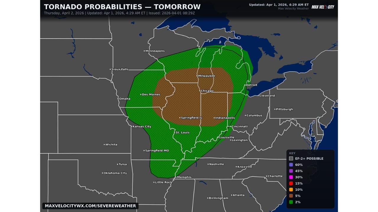
This tornado probability outlook was updated April 1, 2026 at 4:29 AM ET.
The Critical Variable — Morning Convection
Thursday’s tornado threat is not a simple go or no-go scenario. It hinges on one specific atmospheric question that will not be fully answered until Thursday morning itself — whether the overnight and early morning convection clears out of the risk zone fast enough.
When thunderstorms move through a region overnight and into the morning hours, they leave behind a series of atmospheric consequences that directly affect afternoon severe weather potential. Outflow boundaries from dying storms can stabilize the atmosphere at the surface, create cloud cover that limits daytime heating, and disrupt the wind shear profiles that are critical for tornado-producing supercell organization.
If Thursday morning’s convection lingers, stalls, or leaves behind a significant stabilizing layer across Iowa, Illinois, and Wisconsin — the afternoon tornado threat decreases substantially. Storms would struggle to organize into discrete supercells, and the environment for sustained tornado-producing rotation would be compromised.
But if the morning convection clears out efficiently — allowing the sun to heat the surface, rebuild instability, and restore the wind shear profiles — the afternoon atmosphere across this corridor becomes genuinely dangerous. The Gulf moisture already in place, combined with the intense low-level wind shear forecast for Thursday afternoon and the upper-level dynamics pushing through from the west, creates an environment where well-organized supercells can develop and maintain tornadoes across a heavily populated stretch of the Midwest.
This is why forecasters are watching Thursday’s morning trends so closely — and why residents across the risk zone should do the same.
Tornado Probability by Zone — Thursday April 2
The tornado probability map for Thursday identifies two distinct risk zones across the Midwest and Ohio Valley.
5% Tornado Probability With EF2+ Hatching — The Core Zone
The highest tornado probability Thursday is concentrated in a 5% zone with EF2+ significant tornado hatching — centered over a corridor running from Des Moines and Iowa southeastward through Illinois, Wisconsin, and Indiana to St. Louis and Indianapolis.
The specific cities sitting inside or near this core zone include:
| City | State | Tornado Risk |
|---|---|---|
| Chicago | Illinois | 5% / EF2+ possible |
| Milwaukee | Wisconsin | 5% / EF2+ possible |
| Des Moines | Iowa | 5% / EF2+ possible |
| Springfield, IL | Illinois | 5% / EF2+ possible |
| Indianapolis | Indiana | 5% / EF2+ possible |
| St. Louis | Missouri | 5% / EF2+ possible |
| Madison | Wisconsin | 5% / EF2+ possible |
| Rockford | Illinois | 5% / EF2+ possible |
The EF2+ hatching over this zone is a critical designation. It means forecasters believe that if tornadoes develop in this environment, at least some of them have the potential to reach EF2 intensity or stronger — producing winds of 111 mph or greater capable of causing significant structural damage to well-built homes, destroying mobile homes entirely, and turning vehicles and debris into dangerous projectiles.
2% Tornado Probability — The Broader Surrounding Zone
A larger surrounding zone carries a 2% tornado probability — extending from Omaha and Sioux Falls in the northwest through Kansas City, Detroit, Cleveland, Columbus, Cincinnati, Louisville, Lexington, Nashville, and Memphis in the south and east.
| City | State | Tornado Risk |
|---|---|---|
| Omaha | Nebraska | 2% |
| Sioux Falls | South Dakota | 2% |
| Kansas City | Missouri | 2% |
| Detroit | Michigan | 2% |
| Cleveland | Ohio | 2% |
| Columbus | Ohio | 2% |
| Cincinnati | Ohio | 2% |
| Louisville | Kentucky | 2% |
| Lexington | Kentucky | 2% |
| Nashville | Tennessee | 2% |
| Memphis | Tennessee | 2% |
| Little Rock | Arkansas | 2% |
Why the EF2+ Hatching Makes This Setup Serious
A 5% tornado probability sounds like a modest number to many residents — but combined with the EF2+ significant tornado hatching, it tells a very different story.
The hatching designation is added to a tornado probability zone only when forecasters believe the tornadoes that develop in that environment are likely to be stronger than the typical brief, weak tornado. It reflects the intensity of the low-level wind shear profiles forecast for Thursday afternoon — shear values that create the deep, sustained rotation needed for tornadoes to stay on the ground longer and reach higher intensities.
When low-level shear is intense enough to support EF2+ tornadoes, it means the atmosphere is capable of producing storms where the rotating column of air extends through a deep layer from near the surface to well into the mid-levels of the storm. These are the kind of tornadoes that can be long-track — staying on the ground for many miles — and that can cause catastrophic damage to any structure in their direct path.
For Chicago, Milwaukee, Indianapolis, and St. Louis — major metropolitan areas sitting inside the 5% EF2+ zone — the implications are significant. A strong tornado tracking through an urban or suburban area produces damage on a completely different scale than the same tornado moving through rural land. Population density, the concentration of vehicles on roads, and the sheer number of structures in the path all amplify the potential consequences.
The Uptrend Signal — Watch Thursday Morning Forecasts
Forecasters are explicitly watching for an uptrend in Thursday’s risk — meaning the possibility that the SPC upgrades the tornado threat level as Thursday morning develops and the critical morning convection question is answered.
If the morning storms clear efficiently and the afternoon atmosphere recovers as hoped, an upgrade from the current Slight Risk to an Enhanced Risk — Level 3 becomes increasingly likely. Enhanced Risk days are serious severe weather days — they are issued when numerous severe storms are expected, including a few significant tornadoes, and they signal a higher level of forecaster confidence in an organized outbreak.
Residents across the 5% EF2+ zone should check the SPC outlook and local NWS forecasts first thing Thursday morning — an upgrade would be a signal to immediately finalize shelter preparations and treat Thursday afternoon as a genuine severe weather emergency.
Forecast Confidence Level
High confidence on elevated tornado threat Thursday across Iowa, Illinois, Wisconsin, and Indiana — the atmospheric ingredients are in place and the probability map reflects genuine and significant tornado potential.
High confidence on EF2+ tornado potential if supercells organize** — the low-level shear profiles forecast for Thursday afternoon are intense enough to support significant tornado development in any storm that becomes well-organized.
Medium confidence on whether the full tornado potential is realized** — the morning convection clearing question remains the primary uncertainty. If it clears — high threat. If it does not — reduced but not eliminated threat.
High confidence on the Chicago, Milwaukee, Des Moines, Indianapolis, and St. Louis corridor as the highest-risk zone** — the 5% EF2+ core is well-defined and consistent across forecast data.
What Must Happen Before Thursday Afternoon
Check the SPC outlook and your local NWS forecast first thing Thursday morning. The morning convection clearing question will be partially answered by 8 to 10 AM Thursday. If the risk is trending upward and an Enhanced Risk upgrade is issued, treat it as a signal to act immediately.
Have your shelter plan finalized before noon Thursday. Do not wait until the afternoon storms are approaching to figure out where you are going. Know your shelter location at home, at work, and at school. An interior room on the lowest floor away from all windows is the minimum safe option. A basement is the best.
Chicago and Milwaukee residents — you are in one of the largest urban areas inside the 5% EF2+ zone. Urban tornado preparedness requires knowing your building’s safest interior space in advance. High-rise residents should move to lower floors and interior stairwells during tornado warnings — upper floors of tall buildings are not safe during a tornado.
Des Moines and Iowa residents — the core of the 5% zone sits directly over your region Thursday afternoon. This is not a peripheral threat for Iowa — it is the bullseye. Treat Thursday as a serious severe weather day from the moment you wake up.
Indianapolis and St. Louis residents — both cities are inside the 5% EF2+ zone. The afternoon hours carry the highest risk — have plans in place to shelter immediately if a tornado warning is issued for your county Thursday afternoon or evening.
Do not be caught driving when Thursday afternoon storms arrive. Vehicles offer virtually no protection from EF2+ tornadoes. If you must travel Thursday, complete your travel before noon and plan to be in a sturdy building through the afternoon and early evening hours.
The Bottom Line
An elevated tornado threat with EF2 or stronger tornado potential is in place for Iowa, Illinois, Wisconsin, Indiana, and Missouri on Thursday, April 2. The 5% tornado probability zone with EF2+ hatching covers a corridor including Chicago, Milwaukee, Des Moines, Indianapolis, and St. Louis — with a broader 2% zone extending from Omaha and Sioux Falls through Cleveland, Columbus, Louisville, Nashville, and Memphis. The critical factor is whether morning convection clears fast enough to allow supercells to organize during the afternoon and evening — if it does, the tornado threat increases significantly and a risk upgrade becomes possible. Monitor Thursday morning forecasts closely, finalize your shelter plan before noon, and treat Thursday afternoon as a serious severe weather emergency across the entire risk zone.
Stay ahead of dangerous weather before it reaches your door. Visit cabarrusweekly.com for daily tornado outlooks, severe weather coverage, and storm alerts from across the United bunited States — because knowing early is the difference that matters.