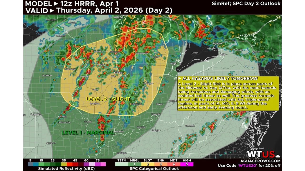
Iowa, Missouri, Illinois, and Wisconsin Face Multiple Rounds of Severe Storms Thursday April 2 With Strong Tornadoes, 60 to 70 MPH Winds, and Possible SPC Upgrade to Enhanced Risk Across Chicago, Milwaukee, Madison, Rockford, and Davenport
UNITED STATES — The severe weather pattern that has been battering the central United States all week is not finished. Thursday, April 2, 2026 brings another significant and potentially escalating severe weather day across the Midwest — with multiple rounds of storms expected from morning through early evening across Iowa, Missouri, Illinois, and Wisconsin. The afternoon round carries the greatest concern, with forecasters warning that some tornadoes may be strong given intense low-level wind shear profiles, and that any storms clustering or growing upscale will be capable of producing 60 to 70 mph wind gusts across a heavily populated corridor. Most significantly — forecasters are explicitly flagging the possibility that the Storm Prediction Center could upgrade Thursday’s risk to a Level 3 Enhanced Risk if forecast uncertainties are resolved favorably.
This forecast is based on the HRRR model initialized April 1, 2026 at 12z, valid Thursday, April 2, 2026.
Why Thursday Is a Particularly Dangerous Setup
Thursday’s severe weather threat carries a specific atmospheric configuration that forecasters are treating with heightened concern — a triple-point regime.
A triple point is the location where three distinct air masses and their associated boundaries converge simultaneously — typically where a cold front, a warm front, and a dry line or stationary boundary all meet at a single geographic focal point. Triple points are meteorologically significant because they concentrate atmospheric energy, moisture, and wind shear into a confined area — creating an environment that is exceptionally favorable for the development of organized, rotating thunderstorms capable of producing strong tornadoes.
The triple-point regime on Thursday is forecast to set up across Iowa, Missouri, Illinois, and Wisconsin — placing the greatest tornado threat directly over one of the most densely populated corridors in the Midwest. Cities including Chicago, Milwaukee, Madison, Rockford, Davenport, Cedar Rapids, and Des Moines all sit within or near this enhanced threat zone.
Multiple Rounds — Morning Through Early Evening
Unlike many severe weather events that peak during a single afternoon window, Thursday’s setup features multiple distinct rounds of storm activity spanning the entire daylight period.
Morning Round — The first round of storms arrives during the morning hours across portions of the risk zone. This initial round carries some severe weather potential but represents a lower threat level than what follows. However, the timing of this first round matters significantly — if it produces substantial rainfall and outflow boundaries across the region, it could either enhance or suppress the afternoon setup depending on exactly how the storms evolve.
Afternoon Round — Peak Threat Window — The most significant and most dangerous round of storms is expected during the afternoon hours — when daytime heating maximizes instability and the cold front pushes into the warm, moist air mass already in place across the Midwest. Storms firing along and just ahead of the cold front during this window will have access to intense low-level wind shear profiles — the atmospheric ingredient most directly responsible for tornado-producing rotation in thunderstorms.
This is the window where strong tornadoes become a realistic concern. The combination of rich Gulf moisture, intense low-level shear, and the triple-point convergence zone creates an environment where well-organized supercell thunderstorms can produce tornadoes that stay on the ground for extended periods and reach significant intensity.
Early Evening — The threat continues into the early evening as storms cluster and grow upscale into larger convective systems. As this upscale growth occurs, the primary threat transitions from discrete tornado-producing supercells toward organized storm clusters and bow echoes capable of producing widespread 60 to 70 mph straight-line wind gusts across the risk zone.
The Possible Enhanced Risk Upgrade — What It Would Mean
One of the most significant elements of Thursday’s forecast is the explicit mention that the SPC could upgrade Thursday’s risk from Level 2 Slight to Level 3 Enhanced Risk if the current forecast uncertainties are resolved.
An Enhanced Risk designation — Level 3 of 5 — is issued when numerous severe storms are expected, including the possibility of a few significant tornadoes, widespread damaging winds, or very large hail. It represents a meaningfully higher threat level than the current Slight Risk and would signal that forecasters have higher confidence in an organized and significant severe weather outbreak across the risk zone.
The uncertainty holding back the Enhanced Risk upgrade right now centers on the timing of the morning round of storms. If the first round fires too aggressively and leaves behind outflow boundaries and stable air, it could suppress the afternoon setup and reduce the threat level. If the morning round is limited or stays further west, the afternoon environment remains pristine and the Enhanced Risk upgrade becomes more likely.
Residents across the Midwest should monitor SPC outlook updates through Thursday morning — an upgrade would be a significant signal to take immediate shelter preparations.
Cities in the Thursday Severe Weather Risk Zone
| City | State | Risk Level |
|---|---|---|
| Chicago / Joliet | Illinois | Slight Risk — possible Enhanced |
| Milwaukee | Wisconsin | Slight Risk — possible Enhanced |
| Madison | Wisconsin | Slight Risk — possible Enhanced |
| Rockford | Illinois | Slight Risk — possible Enhanced |
| Davenport | Iowa | Slight Risk — possible Enhanced |
| Cedar Rapids | Iowa | Slight Risk — possible Enhanced |
| Des Moines | Iowa | Slight Risk — possible Enhanced |
| Fort Wayne | Indiana | Slight Risk |
| Indianapolis | Indiana | Slight Risk |
| Grand Rapids | Michigan | Marginal Risk |
| Detroit | Michigan | Marginal Risk |
| St. Louis | Missouri | Marginal Risk |
| Kansas City | Missouri | Marginal Risk |
| Columbus | Ohio | Marginal Risk |
Primary Threats Thursday April 2
Strong tornadoes — The intense low-level shear profiles forecast for Thursday afternoon across the triple-point regime create an environment where tornadoes that develop are not just possible but could be strong. Low-level shear is the atmospheric ingredient most directly responsible for the violent rotation that produces long-track, intense tornadoes. When low-level shear values reach the levels forecast for Thursday across Iowa, Illinois, and Wisconsin, any supercell that manages to get organized has the potential to produce a significant tornado.
Damaging winds of 60 to 70 mph — As storms cluster and grow upscale through the afternoon and into the early evening, bow echoes and squall line segments will produce widespread straight-line wind gusts across the risk zone. These winds are capable of causing major tree damage, widespread power outages, and structural damage across a large area — independent of any tornado threat.
Isolated hail — While not the headline threat Thursday, isolated hail is possible with the stronger supercell segments — particularly during the afternoon round before storms merge into larger systems.
Forecast Confidence Level
High confidence on severe storm development Thursday across Iowa, Missouri, Illinois, and Wisconsin — the atmospheric setup is well-established and consistent across multiple model runs.
High confidence on the afternoon round being the most significant threat window** — the triple-point environment and low-level shear profiles are locked in for the afternoon hours.
Medium confidence on strong tornado potential** — the environment is favorable, but whether discrete supercells can maintain their organization long enough to produce strong tornadoes depends on storm mode evolution that will become clearer by Thursday morning.
Medium confidence on the Enhanced Risk upgrade** — the possibility is real and explicitly flagged by forecasters, but the morning round timing uncertainty must be resolved before confidence increases enough to warrant the upgrade.
What Midwest Residents Must Do Before Thursday Afternoon
Monitor the SPC outlook first thing Thursday morning. If the Enhanced Risk upgrade is issued, treat it as a signal to immediately finalize all shelter preparations and avoid unnecessary travel through the afternoon and evening hours. An upgrade would mean forecasters have higher confidence in a significant severe weather outbreak — not a marginal one.
Know the difference between the morning and afternoon threat windows. Thursday’s first round of storms in the morning is not the most dangerous period — but it could make roads wet, visibility poor, and conditions generally unsettled. Do not let the morning storms lower your guard for the more dangerous afternoon window.
Have a shelter plan for every location you occupy Thursday. Given the multi-round nature of Thursday’s threat, you may be in different locations during the morning, afternoon, and evening windows. Know your shelter options at home, at work, at school, and at any other location where you might be when the afternoon storms arrive.
Chicago, Milwaukee, and Madison residents — major metropolitan areas within the Slight Risk zone face real severe weather potential Thursday afternoon. Urban infrastructure is not immune to 60 to 70 mph wind gusts or tornadoes. High-rise residents should move to lower floors and interior rooms during tornado warnings — the upper floors of tall buildings are not safe shelter during a tornado.
Iowa residents across Des Moines, Cedar Rapids, and Davenport face the highest tornado potential of the day given the triple-point regime setup. These communities sit in the zone where the most favorable tornado environment is forecast — treat Thursday afternoon as a serious weather emergency day regardless of how the morning appears.
The Bottom Line
Iowa, Missouri, Illinois, and Wisconsin face a multi-round severe weather threat Thursday, April 2 — with the most dangerous window arriving during the afternoon hours when a triple-point regime and intense low-level wind shear create conditions favorable for strong tornadoes. The Storm Prediction Center currently has a Slight Risk in place but has explicitly flagged the possibility of an upgrade to Enhanced Risk if morning storm timing uncertainties are resolved. 60 to 70 mph wind gusts are expected as storms cluster and grow upscale through the evening. Cities including Chicago, Milwaukee, Madison, Rockford, Davenport, Cedar Rapids, and Des Moines all sit within the highest-risk corridor. Monitor Thursday morning SPC updates closely — and treat this as a serious severe weather day regardless of risk level designation.
Stay ahead of dangerous weather before it reaches your door. Visit cabarrusweekly.com for daily severe weather coverage, tornado outlooks, and storm alerts from across the United States — because knowing early is the difference that matters.