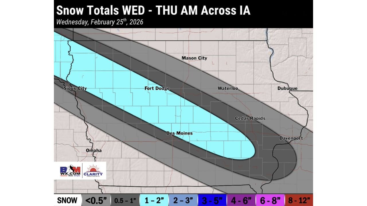
Iowa Winter System Sets Up Narrow 1–2 Inch Snow Band From Sioux City to Davenport Overnight Into Thursday Morning
IOWA — A compact winter system is moving across the state this afternoon and will continue through the overnight hours into Thursday morning, setting up a narrow corridor of accumulating snow across central Iowa.
Narrow Snow Band Targets Central Iowa
Forecast guidance shows a focused band of 1 to 2 inches of snowfall developing from northwest to southeast across the heart of the state. The corridor stretches from Sioux City through Fort Dodge and Des Moines, extending toward Cedar Rapids and into the Quad Cities near Davenport.
This setup suggests the most organized snowfall will be confined to a relatively tight zone rather than widespread heavy totals. Areas just north and south of this axis are likely to see lighter accumulations, generally under an inch in many spots.
Warm Air Limits Heavier Totals
Forecasters note that warmer air aloft is expected to limit higher snowfall amounts, preventing more significant totals from developing. While snow will fall steadily at times within the band, thermal profiles are not supportive of 3–5 inch or higher totals across most of Iowa.
The highest confidence zone remains centered on central Iowa, where mesoscale banding may briefly enhance snowfall rates before the system shifts east by Thursday morning.
Key Cities in the 1–2 Inch Zone
The projected 1–2 inch swath includes several major population centers:
Sioux City in western Iowa sits near the northwestern edge of the band.
Fort Dodge lies near the center of the expected accumulation zone.
Des Moines is positioned within the core of the narrow snow corridor.
Cedar Rapids and Davenport in eastern Iowa are also forecast to receive similar totals as the system exits.
Communities such as Mason City, Waterloo, and Dubuque appear north of the primary band and may see lighter totals depending on subtle shifts in track.
Timing: Wednesday Afternoon Through Early Thursday
Snow develops across western Iowa during the afternoon hours and gradually pushes southeast through the evening. The most consistent accumulation window appears to be late Wednesday evening through the pre-dawn hours Thursday.
By Thursday morning, snowfall should taper off from west to east as the system exits toward Illinois.
Motorists traveling overnight or during the early Thursday commute in central Iowa should anticipate slushy to snow-covered roads, particularly where snowfall briefly intensifies within the narrow band.
Impacts Expected to Remain Moderate
With totals generally capped near 1–2 inches, widespread major disruptions are not anticipated. However, untreated roads could become slick, especially where snowfall rates briefly increase.
The narrow nature of the band means small track shifts could slightly adjust the highest totals north or south, but confidence remains strongest across central Iowa.
Residents across Sioux City, Fort Dodge, Des Moines, Cedar Rapids, and Davenport should monitor local conditions as the system passes through tonight.
If you’re in Iowa, let us know what conditions look like in your area. Share your snowfall totals and road reports with us at CabarrusWeekly.com to help others stay informed.