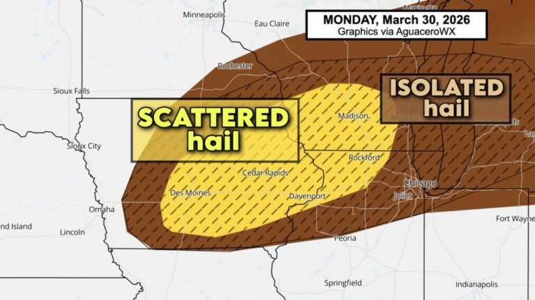
Iowa, Wisconsin, Illinois Face Large Hail Threat Monday as Elevated Supercells Develop, West Texas Also Sees Strong Storm Risk
IOWA — A focused severe weather setup is unfolding Monday across parts of the Midwest, where elevated supercells are expected to produce large to very large hail, while a separate storm risk develops across West Texas.
Elevated Supercells Target Iowa First
Storm development is expected to begin by late afternoon into early evening across Iowa, where atmospheric conditions favor elevated thunderstorm formation.
These storms are not expected to be surface-based, meaning they will form above a cooler layer near the ground. As a result, the tornado threat remains extremely low, but other hazards increase significantly.
The primary concern with these elevated supercells is hail, which could become large and potentially damaging in a short period of time.
Slight Risk Extends Into Illinois and Wisconsin
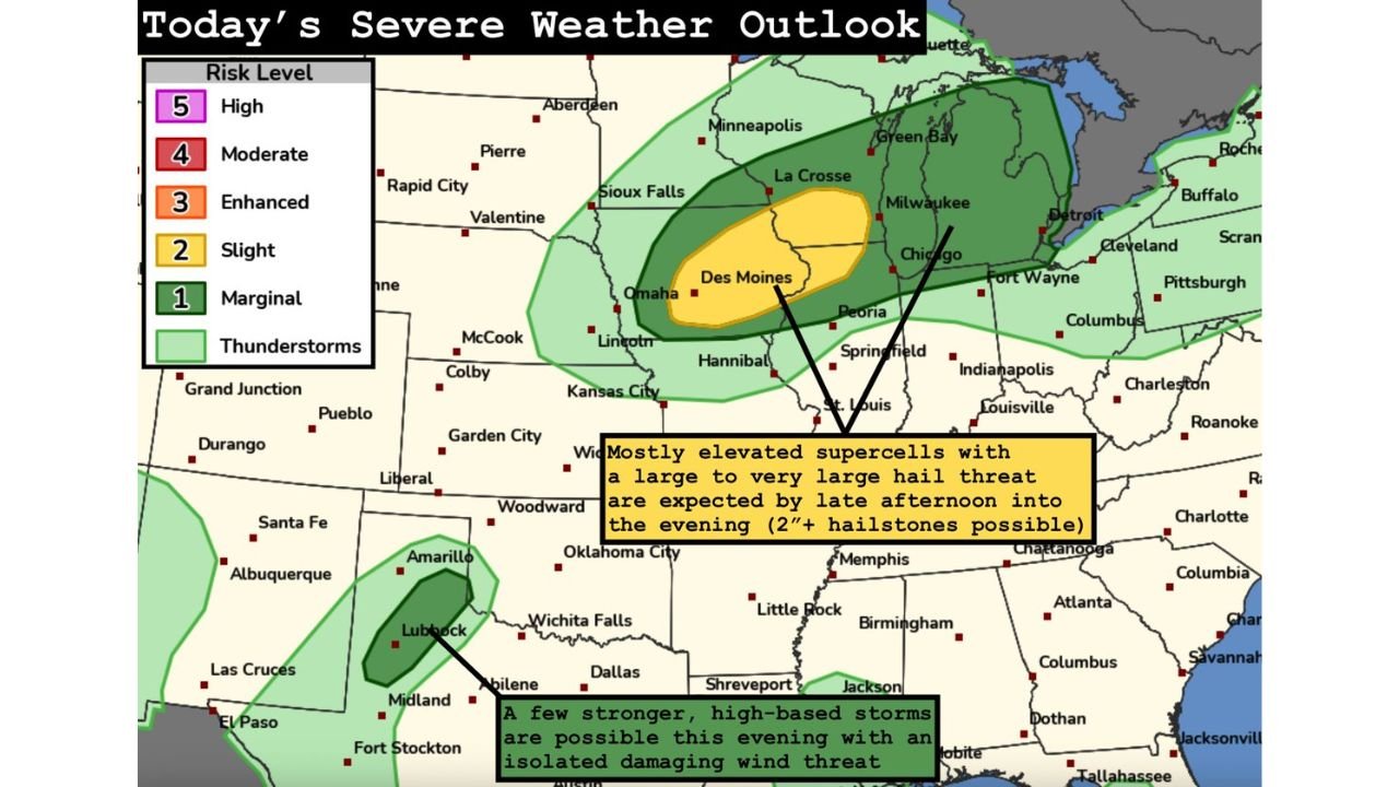
The Storm Prediction Center has outlined a Slight Risk (Level 2 of 5) covering much of Iowa, northern Illinois, and southern Wisconsin.
As storms move east and northeast, they are expected to spread into cities such as Des Moines, Chicago, and Milwaukee, though they may remain elevated during this phase.
This means the severe threat will be more focused on hail production rather than tornado development, especially during the evening hours.
Large to Very Large Hail Main Hazard
Forecast guidance highlights a strong potential for large to very large hail, with some storms capable of producing hailstones approaching or exceeding 2 inches in diameter.
This type of hail can cause damage to vehicles, roofs, and outdoor property, particularly if storms intensify quickly.
Even though the storms may not bring widespread wind damage, the hail threat alone makes this a notable severe weather day across the region.
West Texas Sees Separate Strong Storm Setup
In addition to the Midwest system, a secondary area of concern is developing across West Texas, where a few strong storms may form later in the day.
These storms are expected to be more isolated but could still produce gusty winds and localized impacts, especially in areas near Lubbock and Midland.
Unlike the Midwest setup, the Texas storms are less organized, but still capable of brief strong conditions.
Evening Timing Brings Expanding Storm Coverage
As the evening progresses, storms across the Midwest are expected to expand east and northeast, gradually weakening but still capable of producing hail.
The elevated nature of the storms may allow them to persist after sunset, extending the risk window into the nighttime hours.
Residents in the Slight Risk area should remain alert through the evening, especially as storms move into more populated corridors.
Stay with CabarrusWeekly.com for continued updates, and share what conditions you are seeing in your area as these storms develop across the Midwest and parts of Texas.